Machine Generated Data
Tags
Color Analysis
Face analysis
Amazon
AWS Rekognition
| Age | 26-44 |
| Gender | Female, 59.6% |
| Angry | 15.2% |
| Happy | 27.1% |
| Calm | 15.8% |
| Surprised | 14.8% |
| Confused | 12.4% |
| Disgusted | 6.8% |
| Sad | 7.9% |
Feature analysis
Amazon
Clarifai
AWS Rekognition
| Poster | 51.3% | |

Categories
Imagga
created on 2018-03-23
| paintings art | 92.2% | |
| text visuals | 5.9% | |
| streetview architecture | 1.8% | |
| nature landscape | 0.1% | |
Captions
Microsoft
created by unknown on 2018-03-23
| a close up of a book | 47.2% | |
| close up of a book | 42% | |
| a close up of a book cover | 41.9% | |
Salesforce
Created by general-english-image-caption-blip-2 on 2025-06-27
a map of the battlefield of the battle of the chesapeake
Created by general-english-image-caption-blip on 2025-05-11
a photograph of a map of a map of a map of a map of a map of a
OpenAI GPT
Created by gpt-4 on 2024-12-16
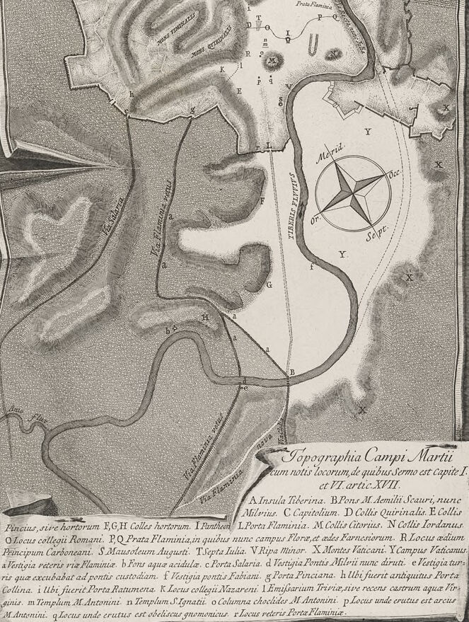
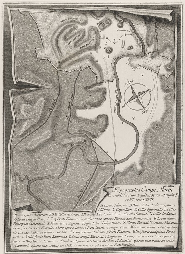
This image is an old, detailed map or plan. It appears to be an etching or an engraving, given the fine lines and shading that provide texture and depth. The map depicts a large open area surrounded by various structures and natural forms, such as hills or mounds. Central to the map is an enclosed, roughly circular space labeled "Martis", which suggests it may be related to Mars, the Roman god of war, and could possibly be an area dedicated to him, like the Campus Martius in Rome.
The map is annotated with Latin text and labels, indicating different locations with letters that correspond to the legend below. There's a compass rose near the center right, showing cardinal directions. The bottom section contains a descriptive text in Latin, giving context to the locations on the map. The overall style and content suggest that this image is a historic document, likely from a period when Latin was used for scholarly or official purposes.
The title “Topographia Campi Martii” translates to "Topography of the Field of Mars," which reinforces the idea that this map might be illustrating part of ancient Rome. The legends and annotations indicate various topographical and architectural features, such as gates, hills, roads, and possibly the locations of significant buildings or statues.
Created by gpt-4o-2024-05-13 on 2024-12-16
This image is an old, detailed map titled "Topographia Campi Martii" which translates to "Topography of the Field of Mars" in English. The map is predominantly black-and-white with various landforms, structures, and features meticulously illustrated. It depicts part of ancient Rome, showcasing geographical features such as hills (like Mons Jo. Euangelistae, Mons Tremelius, etc.), valleys, roads, and what appears to be a river snaking through the landscape.
A notable feature on the map is a large compass rose indicating the cardinal directions ("Merid." for south, "Or." for west, "Sept." for north, and "Or." for east). Several pathways, probably roads of significant importance, are marked and labeled, such as "Via Flaminia."
At the bottom right, there is an extensive legend (in Latin) that describes various locations and points of interest mapped out with corresponding small case letters (a, b, c, etc.). Each of these likely refers to historical landmarks, gates, and regions within the area.
The map appears to be a historical piece intended to document the geography and notable locations in and around the Field of Mars, which was a notable and symbolic area in ancient Rome used for military and public functions.
Anthropic Claude
Created by us.anthropic.claude-3-5-sonnet-20241022-v2:0 on 2025-06-25
This is a historical topographical map titled "Topographia Campi Martii" showing the Campus Martius area of ancient Rome. It appears to be an 18th-century engraving that details various landmarks and geographical features of this important Roman district. The map shows the curve of the Tiber River (labeled "Tiberis") and includes a compass rose in the eastern portion. Various locations are marked with letters and referenced in a detailed legend at the bottom of the map. The terrain is depicted through shading and contour lines showing elevation changes. The map includes notable Roman structures, roads, and architectural features of the time. The style is typical of 18th-century cartography, with ornate lettering and detailed architectural representations. The legend appears to be in Latin and lists various significant locations including temples, monuments, and other Roman landmarks.
Created by claude-3-haiku-20240307 on 2024-12-16
This image appears to be an old map or diagram depicting the layout of an area, possibly a military or historical site. The map contains various labels and markings, including geographical features like hills and rivers, as well as structures such as temples and buildings. There is also a compass rose indicating the cardinal directions. The overall visual style suggests this is an antique or historical document rather than a modern map.
Created by claude-3-5-sonnet-20241022 on 2024-12-16
This is a historical topographical map titled "Topographia Campi Martii" which appears to be from the 18th century (dated XLVII). It shows a detailed layout of part of ancient Rome, specifically the Campus Martius area. The map is rendered in a black and white engraving style and includes various notable features:
- A prominent compass rose in the eastern portion
- The curve of the Tiber River (Tevere)
- Various labeled locations and landmarks in Latin
- Topographical details showing elevation changes through shading
- A detailed legend/key at the bottom of the map listing various points of interest
The map has a decorative cartouche at the bottom containing the title and explanatory text. The overall style is typical of 18th-century cartography, with careful attention to detail and artistic shading to represent terrain. The map appears to be documenting both ancient Roman sites and contemporary (to the time of the map's creation) landmarks, making it an important historical document for understanding the urban development of Rome.
Meta Llama
Created by us.meta.llama3-2-11b-instruct-v1:0 on 2024-12-16
The image is a map of the Campi Martii, an area in ancient Rome. The map is drawn in black ink on white paper and features a compass rose in the center, with the title "Topographia Campi Martii" written in Latin at the bottom.
- Title and Legend
- The title "Topographia Campi Martii" is written in Latin at the bottom of the map.
- The legend is written in Latin and appears to be a list of place names and their corresponding locations on the map.
- Compass Rose
- The compass rose is located in the center of the map and features a stylized representation of the four cardinal directions (north, south, east, and west).
- The compass rose is surrounded by a circle with a diameter of approximately 1 inch.
- Map Features
- The map features several prominent landmarks, including the Tiber River, which runs along the left side of the map.
- The map also shows several roads and paths, including the Via Appia, which runs from the top-left corner of the map to the bottom-right corner.
- The map includes several place names, including the names of hills, valleys, and other geographical features.
- Style and Technique
- The map is drawn in a detailed and realistic style, with intricate lines and shading used to create a sense of depth and texture.
- The map appears to be hand-drawn, with visible brushstrokes and imperfections that give it a unique and human touch.
Overall, the image is a detailed and informative map of the Campi Martii, an area in ancient Rome. The map features a compass rose, place names, and several prominent landmarks, and is drawn in a realistic and detailed style.
Created by us.meta.llama3-2-90b-instruct-v1:0 on 2024-12-16
The image is a map of the area around Rome, Italy. The map appears to be an old illustration, possibly from the 18th or 19th century.
Key Features:
- Map Area: The map depicts the region surrounding Rome, including the Tiber River and various landmarks such as hills, roads, and buildings.
- Illustrations: The map features detailed illustrations of the terrain, including hills, valleys, and waterways. It also includes symbols and markings that likely represent different types of land use, such as agriculture, urban areas, and natural features.
- Labels and Text: The map includes labels and text in Latin, which provide information about the locations and features depicted on the map. Some of the labels appear to be names of places, while others may be descriptive terms or notes about the area.
- Border and Frame: The map has a decorative border and frame, which adds to its aesthetic appeal and suggests that it may have been intended for display or publication.
Overall Impression:
The image presents a detailed and informative map of the Rome area, showcasing the region's geography and features. The use of Latin labels and text adds an air of historical significance and cultural context to the map, making it a valuable resource for researchers and enthusiasts of Roman history and geography.
Amazon Nova
Created by amazon.nova-pro-v1:0 on 2025-02-27
The image is a detailed black-and-white topographical map of a military camp, labeled "Topographia Campi Martii" at the bottom. The map appears to be a historical representation, possibly from the 17th or 18th century, given the style and the Latin text.
The map is oriented with a compass rose in the center-right, indicating cardinal directions. The compass rose features a star with eight points, each labeled with the direction it represents. Surrounding the compass rose are various structures and features, including tents, fortifications, and pathways.
The camp is divided into several sections, each marked with letters and numbers. For example, the upper left section is labeled "A," and the upper right section is labeled "B." The sections are further divided into smaller subsections, indicated by numbers within each lettered section.
The map includes a variety of annotations and labels. Some of these labels identify specific features within the camp, such as "Via Flaminia" (Flaminian Way) and "Via Salaria" (Salarian Way), which are ancient Roman roads. Other labels indicate the locations of specific buildings or areas within the camp, such as "Porta Pinciana" (Pinciana Gate) and "Porta Salaria" (Salarian Gate).
The map also includes a legend at the bottom, which provides additional information about the symbols and labels used on the map. The legend is written in Latin and includes descriptions of various features, such as "Locus ad portam" (place at the gate) and "Via publica" (public road).
Overall, the map provides a detailed and comprehensive representation of the military camp, highlighting its layout, key features, and important locations. The use of Latin and the historical style suggest that the map is a valuable historical document, offering insights into the organization and structure of military camps during the period in which it was created.
Created by amazon.nova-lite-v1:0 on 2025-02-27
The image is a historical map of ancient Rome, specifically focusing on the Campus Martius area. The map is titled "Topographia Campi Martii" and is labeled with various landmarks and structures from ancient Rome. The map is divided into sections with labels such as "A," "B," "C," and "D," each pointing to different locations within the city. The map includes a compass rose in the center, indicating the cardinal directions. The text on the map is in Latin, providing historical and geographical information about the area. The map also includes a detailed illustration of the Tiber Island, which is located in the middle of the Tiber River.
Google Gemini
Created by gemini-2.0-flash-lite on 2025-05-26
Here's a description of the image:
Overall Impression:
The image is a detailed, vintage-style map of an area. It's likely a historical or topographical representation, given its style and the presence of Latin text. The map seems to depict a city or region, with features like rivers, roads, hills, and marked points of interest.
Specific Features:
- The Layout: The map is oriented with north at the top and features a river running diagonally. The area appears to be quite hilly with significant areas marked.
- Key Elements:
- A prominent river dominates the scene, meandering its way through the depicted landscape.
- There is a compass rose in the bottom right corner, helping with orientation.
- Roads are depicted as fine lines, with the notable "Via Flaminia" mentioned.
- The "Tiberis Fluvivs" is marked as the main river of the area.
- Text and Markings:
- The image is richly annotated with Latin, clearly labeling various places, structures, and topographical features.
- Letters and symbols (A, B, C, etc.) correspond to a legend at the bottom, allowing for the identification of landmarks.
- The title "Topographia Campi Martii" and additional text provides context to the map.
Style & Context:
- Age and Technique: The image is reminiscent of a copperplate engraving or similar printmaking technique, indicated by the delicate lines and detail.
- Historical Significance: The style and subject matter suggest that the map originates from a period where cartography was a craft. It is likely illustrating an area in the ancient world, and provides insights into the city planning and landscape of the time.
- Detail: The map shows a considerable degree of detail, indicating that it was created with care and likely for a specific purpose, such as scholarly research or reference.
In summary, this is a well-executed historical map that offers a glimpse into the geographical and topographical aspects of a historical region with a lot of information to be determined.
Created by gemini-2.0-flash on 2025-05-26
Here's a description of the image:
The image is an old-fashioned, detailed map titled "Topographia Campi Martii." The map is rendered in a black and white, engraved style, giving it an antique look.
The map depicts an area with topographical features such as hills and mountains labeled as "MONS ESOVILENV," "MONS PALATINVS," and "MONS VIMINALIS." There are also roads, including "Via Flaminia vetus" and "Via Salaria."
A river, "TIBERIS FLUVIVS," meanders through the landscape. A compass rose with labeled directions ("Merid", "Occ", "Sept", "Or") is positioned near the river.
Various landmarks and points of interest are marked with letters. At the bottom of the image, a key provides descriptions for each of these lettered locations. These locations include "Insula Tiberina", "Pons M. Aemilii Scauri", "Capitolium", and "Porta Flaminia." The key also includes descriptions for smaller landmarks like "Vestigia veteris via Flaminiae" and specific temples and locations.
The style and content suggest the map is historical, likely dating from the era of detailed cartography.
Mistral Pixtral
Created by us.mistral.pixtral-large-2502-v1:0 on 2025-05-31
The image is a historical map titled "Topographia Campi Martii," which translates to "Topography of the Field of Mars." It depicts the layout of the Campus Martius, an area in ancient Rome, based on information from various historical sources, including the works of public records and the writings of authors from the first and sixth centuries.
The map includes several key landmarks and features, each labeled with letters and corresponding descriptions provided in the legend at the bottom. Here is a summary of the labeled points and their descriptions:
- A: Insula Liberina
- B: Pons M. Aemilii Scauri, nunc Milvius
- C: Capitolium
- D: Collis Quirinalis
- E: Collis Vaticanus
- F: Porta Flaminia
- G: Collis Ianiculensis
- H: Collis Esquilinus
- I: Pantheon
- K: Locus collegii Nazareni
- L: Porta Salaria
- M: Mons Pincius
- N: Campus Vaticanus
- O: Locus collegii Romani
- P: Prata Flaminia in quibus nunc campus Florae et ades Rinuccinorum
- Q: Locus adium Principum Carbonariani
- R: Mausoleum Augusti
- S: Mons Vaticanus
- T: Via Lata
- V: Porta Pinciana
- X: Locus et cruces est arcus M. Antonini
- Y: Locus et cruces est obeliscus gnomonicus
- Z: Locus et cruces est arcus M. Antonini
Additional features include:
- Fincus: A strip of land
- Via Flaminia: A road
- Via Lata: A broad road
- Porta Ratumena: A gate
The map is oriented with a compass rose indicating the cardinal directions (North, East, South, West) at the top right. The layout shows the Tiber River (Tiberis) flowing through the area, with various hills, gates, roads, and significant buildings marked. The map provides a detailed representation of the topography and significant locations within the Campus Martius during ancient Roman times.
Qwen
Text analysis
Amazon