
Machine Generated Data
Tags
Color Analysis
Feature analysis
Amazon
Clarifai
AWS Rekognition
| Airplane | 82.6% | |
Categories
Imagga
created on 2019-05-31
| paintings art | 100% | |
Captions
Microsoft
created by unknown on 2019-05-31
| a close up of text on a white background | 53.7% | |
| a close up of text on a white surface | 53.3% | |
| a close up of text on a black background | 47.1% | |
Clarifai
Created by general-english-image-caption-clip on 2025-07-11
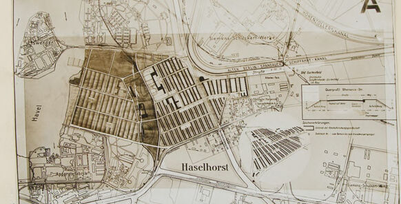
plan of the extension to the house.
Salesforce
Created by general-english-image-caption-blip on 2025-05-04
a photograph of a map of a city with a map of a city
OpenAI GPT
Created by gpt-4o-2024-11-20 on 2025-06-09
This image appears to depict a historical map or technical drawing of an area labeled "Haselhorst," presumably a region along the Havel River. The map includes detailed layouts of streets, industrial zones, waterways, and other urban features. It is presented on a large, plain canvas or background, with the map itself centralized and smaller in scale relative to the surrounding blank space. In the upper right corner, the letter "A" is printed prominently. The map also includes annotations, labels, and possibly a legend to indicate specific features or data. Its style suggests an architectural or urban planning document, possibly related to infrastructure or development within Haselhorst.
Created by gpt-4o-2024-08-06 on 2025-06-09
The image depicts a historical map. Centrally placed within a larger, plain background, the map is somewhat small and appears to be fastened or pasted onto the larger canvas. It shows an area labeled "Haselhorst," suggesting a location within Germany. The map includes intricate details, such as layouts of roads, canals, and possibly plots of land or buildings. The nearby river is marked as "Havel." The style indicates an architectural or urban planning map with annotations and drawings to convey specific aspects or measurements. In the upper-right corner of the map, there is a large letter "A," possibly indicating a section or specific plan associated with the map.
Anthropic Claude
Created by anthropic.claude-3-haiku-20240307-v1:0 on 2025-06-14
The image appears to be a detailed map or plan of a town or city. It shows the layout of various neighborhoods, streets, and buildings, with labels indicating the names of certain areas, such as "Haselhorst". The map includes a grid system and appears to be oriented with north at the top. Overall, the image provides a comprehensive visual representation of the urban landscape depicted.
Created by us.anthropic.claude-3-5-sonnet-20241022-v2:0 on 2025-06-14
This image appears to be a historical map or city plan of Haselhorst, which is labeled in the center of the image. It's a sepia-toned or brownish map showing the layout of streets, buildings, and various districts or zones. The map includes what appears to be industrial or residential areas with regular grid patterns in some sections, while other areas show more irregular development. There's a river or water body visible on one side of the map. The map has a letter 'A' marked in the top right corner, suggesting it might be part of a larger series of maps. The level of detail suggests this was likely used for urban planning or administrative purposes. The style and appearance indicate it's probably from the early to mid-20th century.
Meta Llama
Created by us.meta.llama3-2-11b-instruct-v1:0 on 2025-05-29
The image is a map of an area, likely a city or town, with various buildings and roads labeled. The map appears to be hand-drawn and features a sepia tone color scheme.
- Map Overview
- The map is rectangular in shape and has a light brown background.
- It is divided into several sections, each representing a different area or district within the city.
- The map includes various symbols and markings, such as lines, dots, and letters, which likely represent different features or landmarks.
- Buildings and Roads
- Several buildings are depicted on the map, including what appears to be a large church or cathedral in the center of the image.
- There are also several roads and streets shown, including a main road that runs through the center of the map.
- Some of the buildings and roads are labeled with names or numbers, while others are not.
- Labels and Text
- The map includes several labels and pieces of text, including the name of the city or town ("Haselhorsl") and the names of some of the buildings and roads.
- Some of the text is written in a foreign language, possibly German or Dutch.
- Overall Impression
- The map appears to be a detailed and accurate representation of the city or town, with many features and landmarks included.
- The use of a sepia tone color scheme gives the map a vintage or historical feel, suggesting that it may be an older map or a reproduction of an older map.
In summary, the image is a map of a city or town, likely created in the past, which shows various buildings and roads, as well as labels and text. The map appears to be detailed and accurate, with many features and landmarks included.
Created by us.meta.llama3-2-90b-instruct-v1:0 on 2025-05-29
The image depicts a map of an area, likely a city or town, with various features and labels. The map is presented in a sepia tone, giving it an aged appearance.
Key Features:
- Map Content: The map appears to be a historical or vintage representation of the area, showcasing streets, buildings, and other geographical features.
- Labels and Annotations: Several labels and annotations are visible on the map, including place names, street names, and possibly other relevant information.
- Sepia Tone: The sepia tone of the map suggests that it may be an older document or a reproduction of a historical map.
- Background: The background of the image is a plain beige color, which helps to focus attention on the map itself.
Overall Impression:
The image presents a detailed and informative map of an area, likely created for historical or educational purposes. The use of a sepia tone adds a sense of nostalgia and authenticity to the image, making it visually appealing and engaging.
Amazon Nova
Created by amazon.nova-lite-v1:0 on 2025-06-04
The image is a map of an area with a white background and a border around it. The map has a brown color and shows the area with buildings, roads, and waterways. The map has a label "Haselhorst" in the center, and the map is divided into two sections, with the upper section having a label "A" on the right side. The map also has a label "Havel" on the left side.
Created by amazon.nova-pro-v1:0 on 2025-06-04
The image is a map of an area called Haselhorst, which is a neighborhood in Berlin, Germany. The map is a vintage black and white image, possibly from an old book or document. The map shows the layout of the streets, buildings, and other landmarks in the area. The map is surrounded by a white border, which gives it a vintage look. The map is labeled with the letter "A" in the top right corner.
Google Gemini
Created by gemini-2.0-flash-lite on 2025-05-01
Here's a description of the image:
The image is a top-down view of a detailed map, likely a blueprint or architectural plan. The map is centered on the word "Haselhorst" and features a canal, rivers, and a variety of buildings. The map has a light sepia tone, and is set against a light cream background.
Created by gemini-2.0-flash on 2025-05-01
The image shows a vintage map of an area called Haselhorst. The map is in shades of brown and black, and it appears to be overlaid on a larger sheet of cream-colored paper, as though it's a document that has been pasted or attached to a backing. The map details the layout of streets, buildings, and waterways, including a river labeled "Havel." There are areas with dense, grid-like patterns, suggesting urban development or industrial complexes. Text and annotations are visible throughout the map, providing labels and potentially additional information about the area. The overall effect is one of historical documentation or urban planning.
Mistral Pixtral
Created by us.mistral.pixtral-large-2502-v1:0 on 2025-05-30
The image is a detailed historical map, likely from the early to mid-20th century, showing a section of a city or town. The map is labeled with the letter "A" in the top right corner. It features various buildings, streets, and landmarks, meticulously drawn with intricate details.
Key features of the map include:
Buildings and Structures: The map shows numerous buildings, including residential and possibly commercial structures. The buildings are depicted with different shading and patterns, indicating various types of constructions and materials.
Streets and Paths: The streets are clearly marked, showing the layout of the area. Some streets are labeled with names, such as "Haselhorst."
Railway Lines: There are railway tracks depicted, indicating the presence of a railway system in the area. This suggests that the area might have been a transportation hub or had significant railway activity.
Water Bodies: There are areas marked with a different shading, likely representing water bodies such as rivers or canals.
Labels and Annotations: The map includes various labels and annotations, providing additional information about specific locations and features within the area.
Scale and Orientation: The map includes a scale and orientation indicator, helping viewers understand the relative sizes and directions of the features depicted.
Overall, the map provides a comprehensive view of the urban layout, including infrastructure, transportation, and possibly industrial or residential zones. It is a valuable historical document for understanding the development and organization of the area during that time period.
Qwen
Created by Qwen/Qwen2.5-VL-7B-Instruct on 2025-07-03
The image is a historical map showcasing the area of Haselhorst, which is located in the Havel region. The map appears to be a detailed schematic, likely used for urban planning or historical documentation. It includes labeled streets and geographical features such as a canal and the Havel River. The map is monochromatic, with a sepia or brown tone, and the labels and annotations are in black. The map includes smaller inset sections that might provide additional details or measurements. The design suggests it is a professional map, possibly from the early 20th century.
Created by Qwen/Qwen2.5-VL-72B-Instruct on 2025-07-03
This image shows a detailed architectural or urban planning map of an area labeled "Haselhorst." The map appears to be a drawing or blueprint, possibly from the mid-20th century, given the style and the presence of the Havel river, which is a waterway in Germany.
The map includes various elements such as:
- Buildings and structures, including what seems to be a large industrial or residential area with rows of uniform buildings.
- Roads and pathways connecting different parts of the area.
- A river labeled "Havel," which is a significant waterway in Germany.
- A legend or key in the bottom right corner, which likely explains the symbols and codes used in the map.
- The letter "A" in the top right corner, possibly indicating a section or area within a larger map.
The map is set against a light beige background, and the drawing is done in a monochromatic style, using shades of brown and black. The overall layout suggests a planned urban or industrial area, with a focus on organization and infrastructure.
Text analysis
Amazon


