Machine Generated Data
Tags
Color Analysis
Categories
Imagga
| text visuals | 48.3% | |
| streetview architecture | 44.5% | |
| paintings art | 7% | |
Captions
Microsoft
created by unknown on 2019-05-31
| a close up of a map | 64.5% | |
| close up of a map | 60% | |
| a map with text | 45.1% | |
Clarifai
created by general-english-image-caption-blip on 2025-05-22
| a photograph of a map of a map of a city | -100% | |
Google Gemini
Created by gemini-2.0-flash-lite on 2025-05-15
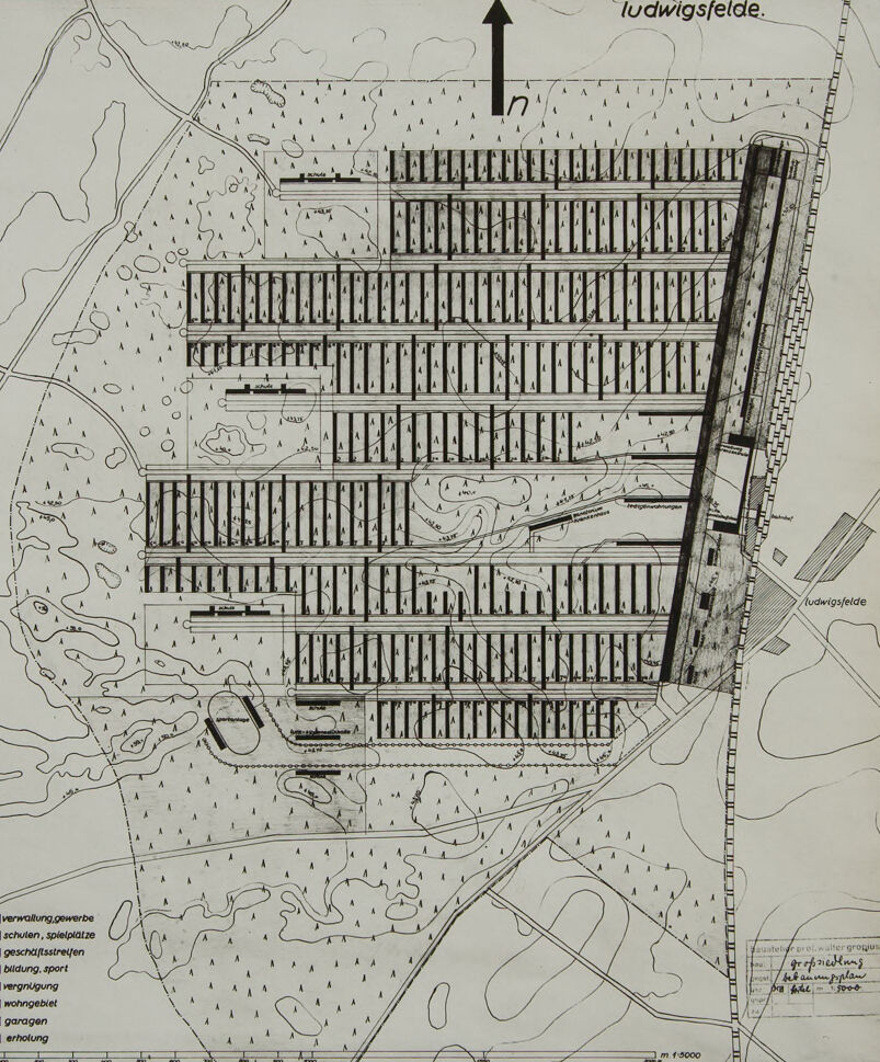
The image is a black and white architectural plan, likely a site plan or master plan, of a residential area or development. Here's a breakdown of what's visible:
Layout & Features:
- Grid-like Structure: The main focus of the plan is a series of parallel rows of rectangular structures. These likely represent residential blocks or housing units.
- Roadways & Access: The rectangular blocks are organized along what appear to be planned roadways, with spaces between them. A major road seems to run along the right edge.
- Land Contours: The plan includes contour lines, indicating the elevation and topography of the land. This suggests the plan considers the natural features of the site.
- Green Areas & Open Spaces: In the surrounding areas are patches marked, probably representing areas for leisure, parks, or undeveloped terrain.
- Additional Structures: Besides the housing blocks, there are smaller, differently-shaped structures that might represent public buildings, commercial areas, or schools.
- Legend: A legend is visible at the bottom left, showing the meaning of different shading styles for the elements of the design, as well as, scales.
Orientation & Direction:
- North Arrow: There is a large black arrow at the top, marking the north direction.
- Labels: Labels, such as "Ludwigsfelde" are on the top and right sides, likely identifying the area or a nearby town.
Additional details:
- Scale: The plan is drawn at a scale of 1:5000
- Author: It also includes the signature of Walter Gropius, possibly indicating that he was involved in the creation of the plan.
- Purpose: The presence of an architectural plan, including a master plan or site plan, indicates that it may be for a residential area or planned residential development.
Created by gemini-2.0-flash on 2025-05-15
Here's a description of the image:
The image is a black and white architectural plan or map, likely of a planned residential area. The word "ludwigsfelde" appears at the top right and bottom right of the image, suggesting the location. A large arrow pointing upwards indicates north.
The plan details a grid-like layout of numerous rectangular blocks, densely packed together. These blocks likely represent residential buildings. A wide, dark stripe runs diagonally through the right side of the planned area, potentially representing a major road or transportation corridor.
The surrounding areas are marked with symbols representing vegetation, possibly trees, and contour lines indicating changes in elevation. A key at the bottom left identifies different area types such as administration/commercial, schools/playgrounds, commercial strips, educational facilities/sports, recreation, residential, garages, and relaxation areas.
The scale of the plan is noted as "m 1:5000" (1 meter on the plan represents 5000 meters in reality). Some handwritten text appears on the bottom right with the name "gropius" and the term "bebauungsplan" (development plan).
Text analysis
Amazon