Machine Generated Data
Tags
Color Analysis
Feature analysis
Amazon
Clarifai

AWS Rekognition
| White Board | 60.9% | |

Categories
Imagga
created on 2023-01-30
| paintings art | 99.5% | |
Captions
Microsoft
created by unknown on 2023-01-30
| map | 100% | |
Clarifai
No captions written
Salesforce
Created by general-english-image-caption-blip on 2025-04-29
a photograph of a map of a map of a map of a map of a map of a
Created by general-english-image-caption-blip-2 on 2025-06-27
a map of the city of korea
OpenAI GPT
Created by gpt-4 on 2024-12-03
This image is a map displaying various geographic features with great artistic detail. It appears to be a historical map, drawn in a style that suggests it could be from a medieval manuscript or a depiction of an earlier period, considering its hand-drawn and colored appearance.
The map is oriented with East (E) at the top, rather than the traditional North, as indicated by the compass rose on the left side denoting North (N), East (E), South (S), and West (W). The landscape is portrayed in a schematic manner, with stylized depictions of mountains, rivers, fortifications, towns, and other settlements. The bodies of water (rivers and lakes) are colored in blue, while the raised areas that could represent hills or mountains have a greenish hue. There are numerous place names and possibly other annotations inscribed throughout the map, most likely in an East Asian language, suggesting the map could be of a location in that region.
Also notable are the ships illustrated near the bottom of the map (indicating the southern direction), suggesting that some body of water is present at this edge of the map. It's worth mentioning that the exact historical and geographical context of the map is not clear from the image alone without further information on its origins and the text it contains.
Created by gpt-4o-2024-05-13 on 2025-01-02
This image represents a historical or hand-drawn map featuring a landscape with various geographical elements. Key features of the map include rivers, mountains, and multiple settlements or towns indicated by clusters of small illustrations of houses or buildings, many of which are labeled with text.
- The map is oriented with North at the left and East at the top.
- Water bodies, including rivers and possibly lakes, are prominently illustrated and meander through the terrain.
- The landscape features rolling hills or mountains, and areas of vegetation are indicated by shades of green.
- Various buildings and settlements are distributed throughout the map, each marked with specific names or identifiers written in a script.
- There are illustrations of boats on the water bodies, suggesting regions of navigation or travel.
- Sections of the map contain detailed imagery, such as clustered buildings within walled areas or fortifications, hinting at towns or cities.
- The coastal regions show boats or ships offshore, indicating maritime activities.
- The map includes artistic and decorative elements typical of older, hand-drawn maps, with a focus on geographical and topographical representation mixed with illustrative details.
The map is depicted across two pages, with a visible crease in the center where the pages meet. It is both an informational and a decorative representation of the landscape it details.
Anthropic Claude
Created by claude-3-5-sonnet-20241022 on 2024-12-28
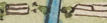
This is a historical Japanese map or geographical illustration, likely from the Edo period. It shows a coastal region with various settlements, fortifications, and geographical features. The map is drawn in a traditional East Asian style using watercolors, with green indicating land areas and blue showing rivers and waterways.
The map features numerous small buildings or structures represented by simple rectangular shapes scattered across the landscape. There are also several circular or oval formations that appear to be fortified settlements or castles. Mountains are depicted using a simple, stylized technique with brown shading.
Along the coastline, there are several small boats or ships drawn in a minimalist style. The map includes Japanese text labels and cardinal direction markers, with 'N' and 'W' visible on the edges. The waterways appear to form a complex delta or river system that extends inland from the coast.
The overall color palette is muted, with soft greens, blues, and browns, typical of historical Japanese cartography. The paper shows some aging and discoloration, suggesting this is a historical document.
Created by claude-3-haiku-20240307 on 2024-11-27
This appears to be a hand-drawn map of a geographical region. The map depicts various landforms, rivers, towns, and other landmarks. The map is oriented with north at the top, and includes annotations and details in what seems to be an Asian script. The overall style and content suggest this is an early or historical map, likely of a region in East Asia.
Created by us.anthropic.claude-3-5-sonnet-20241022-v2:0 on 2025-06-26
This appears to be a historical Japanese or East Asian map, painted in a traditional style with watercolors. The map shows a coastal region with various settlements, rivers, and topographical features. The landscape is depicted in soft greens and browns, with blue waterways winding through the terrain. Several fortified settlements or towns are shown as circular or rectangular enclosures scattered across the landscape. Small buildings or structures are represented by simple rectangular shapes throughout the map.
The coastline is clearly marked along the bottom of the map, with what appear to be small boats or ships drawn in the water. Mountains or hills are illustrated using simple brush strokes in brown tones. The map includes some Japanese characters and text annotations. Cardinal directions are marked, with 'N' visible on the left side and 'W' at the bottom.
This appears to be a strategic or administrative map, possibly from the Edo period, showing the relationship between various settlements, waterways, and defensive positions in this particular region.
Meta Llama
Created by us.meta.llama3-2-90b-instruct-v1:0 on 2024-12-25
The image depicts an open, aged book featuring a hand-drawn map of a region with a river running through it. The map is rendered in muted colors, with green representing land and blue indicating waterways. The river originates from the top-left corner and flows downwards, dividing into two branches that eventually merge again at the bottom center of the page.
The map includes various symbols and markings, such as small buildings, trees, and what appears to be a wall or barrier along the bottom edge. The presence of these features suggests that the map may be depicting a specific location or region, possibly with historical or cultural significance.
The overall appearance of the map, including its age and the style of the drawings, implies that it may be a reproduction or a scan of an original document from an earlier time period.
Created by us.meta.llama3-2-11b-instruct-v1:0 on 2024-11-23
The image presents a hand-drawn map of an area, likely a region or city, with various features and landmarks depicted. The map is rendered in a mix of blue, brown, and green hues, with black text and symbols.
Key Features:
- Geographical Features:
- Rivers: The map features several rivers, including a prominent one that runs through the center of the area.
- Mountains: Hills and mountains are scattered throughout the region.
- Coastline: The area appears to have a coastline, with a body of water visible along the bottom edge of the map.
- Buildings and Structures:
- Houses: Many small houses are scattered throughout the region, often clustered together in groups.
- Fortifications: Some areas feature fortifications, such as walls or towers, which may indicate the presence of a city or town.
- Other Structures: Other structures, such as bridges, roads, and buildings, are also depicted on the map.
- Text and Symbols:
- Place Names: The map includes place names, written in a foreign language, which may indicate the location of specific towns or landmarks.
- Symbols: Various symbols, such as arrows, circles, and lines, are used to represent different features or concepts on the map.
- Color Scheme:
- Blue: The rivers and bodies of water are depicted in blue.
- Brown: The hills and mountains are shown in brown.
- Green: The grassy areas and vegetation are represented in green.
- Black: The text and symbols are written in black ink.
Overall:
The map appears to be a detailed and informative representation of a specific region or city, with a focus on geographical features, buildings, and infrastructure. The use of color and symbols adds depth and clarity to the map, making it easier to navigate and understand.
Amazon Nova
Created by amazon.nova-pro-v1:0 on 2025-01-04
The image shows an old map of a region, possibly of a country. The map is drawn on a piece of paper, and it is folded into two parts. The map shows the geographical features of the region, including mountains, rivers, and cities. The map also includes some text, possibly indicating the names of the cities and other features. The map is drawn in a style that is typical of old maps, with a focus on accuracy and detail.
Created by amazon.nova-lite-v1:0 on 2025-01-04
The image shows an antique map with a green background and various illustrations and text. The map is divided into sections with different colored borders, and it appears to be an old map of a region, possibly a country or a specific area. The map has a compass rose in the upper right corner, indicating the directions North, East, South, and West. The text on the map is in a foreign language, and there are illustrations of buildings, mountains, and other landmarks.
Google Gemini
Created by gemini-2.0-flash on 2025-04-26
Here's a description of the image:
The image is a scanned two-page spread of what appears to be a hand-drawn map. The map has a light green and pale blue color palette. It seems to depict a geographical area with rivers, landmasses, and settlements.
Key features of the map include:
- Rivers: Winding blue rivers flow across the landscape, connecting different areas.
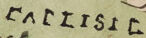
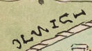
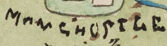
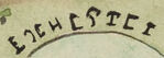
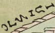
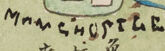
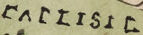
- Settlements: Various structures, possibly representing towns or villages, are scattered throughout the map. They are labeled with names like "LONDON," "CARLISLE," "NEWCASTLE," "HULL," "LEICESTER," "CAMBRIDGE," and others. Some names appear in both English and a script that might be Asian (possibly Chinese or Japanese).
- Compass Rose: North (N), East (E), South (S), and West (W) are indicated at the appropriate edges of the map.
- Topography: There are indications of hills or mountains in some areas, represented by green, rounded shapes.
- Symbols: Small symbols are used to represent various elements, such as trees, boats, and buildings.
- Coastal Features: The map includes coastlines with what look like docks or piers jutting into the water. There are also ships.
- Text: The text is integrated into the map, labeling places and possibly providing other information.
The overall style suggests that the map is historical, possibly from the early modern period, given its aesthetic and the way the information is presented.
Created by gemini-2.0-flash-lite on 2025-04-26
Here's a description of the image:
This is an illustration of a map. It appears to be a hand-drawn map, likely from a historical context. The style of the map is illustrative and somewhat naive, with a focus on the representation of places and features rather than precise cartographic accuracy.
Key features:
- Stylized Representation: The map employs a decorative style, with buildings and features represented in a simplified manner.
- Coloring: The map is colored.
- Landscape: The map seems to represent a landscape with rivers, bodies of water, and hills or islands.
- Text: There is text on the map. The script appears to be non-Latin, possibly East Asian.
Overall, the image presents as an interesting historical artifact, likely a map from an older time period and in a unique style.
Mistral Pixtral
Created by us.mistral.pixtral-large-2502-v1:0 on 2025-04-25
The image depicts an old, hand-drawn map, likely of historical or geographical significance. Here are the key details:
Orientation: The map is oriented with north at the top, as indicated by the letter "N" on the left side.
Geographical Features:
- Rivers: Several rivers are depicted in blue, winding through the landscape.
- Mountains and Hills: There are various elevated areas shown in brown and green, indicating hills and mountains.
- Forests and Vegetation: Green areas likely represent forests or vegetated regions.
Settlements and Structures:
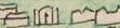
- Numerous small buildings and structures are scattered across the map, indicating settlements or towns.
- Larger, more detailed structures are present, possibly representing significant buildings or landmarks.
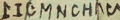
- There are labels and names written in a script that appears to be non-Latin, possibly indicating place names or notable locations.
Annotations and Symbols:
- The map includes various annotations and symbols, which might represent different types of landmarks, resources, or points of interest.
- There are small illustrations of ships near the bottom, suggesting the presence of water bodies or maritime activity.
Color and Style:
- The map uses a variety of colors, including green, blue, brown, and orange, to differentiate between different types of terrain and features.
- The style is reminiscent of traditional cartography, with a focus on detail and illustration.
Overall, the map appears to be a detailed and intricate representation of a specific region, likely created for navigational, administrative, or historical purposes.
Qwen
Created by Qwen/Qwen2.5-VL-72B-Instruct on 2025-06-26
This image is a hand-drawn map, likely of a fictional or stylized representation of a region. The map is oriented with the cardinal directions noted in the corners: North (N), East (E), South (S), and West (W). The map features several distinct elements:
Geographical Features:
- There are various landmasses, islands, and bodies of water. The water bodies are depicted in blue, with some areas showing waves or ripples.
- Hills and mountains are represented with simple brown and green shading.
Settlements and Structures:
- Numerous small buildings or houses are scattered across the landmasses, suggesting settlements.
- Some larger structures, possibly towns or cities, are labeled with names. For example, "LONDON" is prominently labeled in the center.
- There are also some circular structures that could represent forts or other significant buildings.
Labels and Text:
- Various labels in different languages or scripts are present. Some labels are in what appears to be Latin script, while others are in a non-Latin script, possibly Chinese or another East Asian script.
- The labels seem to name different places or features on the map.
Other Elements:
- There are some symbols or illustrations, such as animals or other objects, which might be part of the map's legend or decorative elements.
- The map has a somewhat whimsical or fantasy-like style, with a mix of realistic and imaginative elements.
Overall, the map appears to be a creative and detailed depiction of a region, possibly from a fictional world or a stylized representation of a real place. The combination of different scripts and the whimsical style suggest it could be from a book, game, or other creative work.
Created by Qwen/Qwen2.5-VL-7B-Instruct on 2025-06-26
The image depicts a hand-drawn map featuring a stylized representation of an island, divided into sections with various labeled areas. The map includes green and brown landmasses, with blue areas indicating water bodies. There are several labeled places and rivers on the map, with some of the labels written in a combination of English and what appears to be Chinese characters. The map includes directional indicators (N, S, E, W) at the corners. The artistic style suggests it might be an old map, possibly from the 18th or 19th century, given the coloration and the method of labeling. The details on the map, such as the rivers and the labeled areas, suggest it might be depicting a specific region or area with some level of importance.
Text analysis
Amazon