Machine Generated Data
Tags
Color Analysis
Feature analysis
Amazon
| White Board | 86.9% | |
Categories
Imagga
| paintings art | 100% | |
Captions
Microsoft
created on 2023-01-31
| map | 99.8% | |
OpenAI GPT
Created by gpt-4 on 2024-12-03
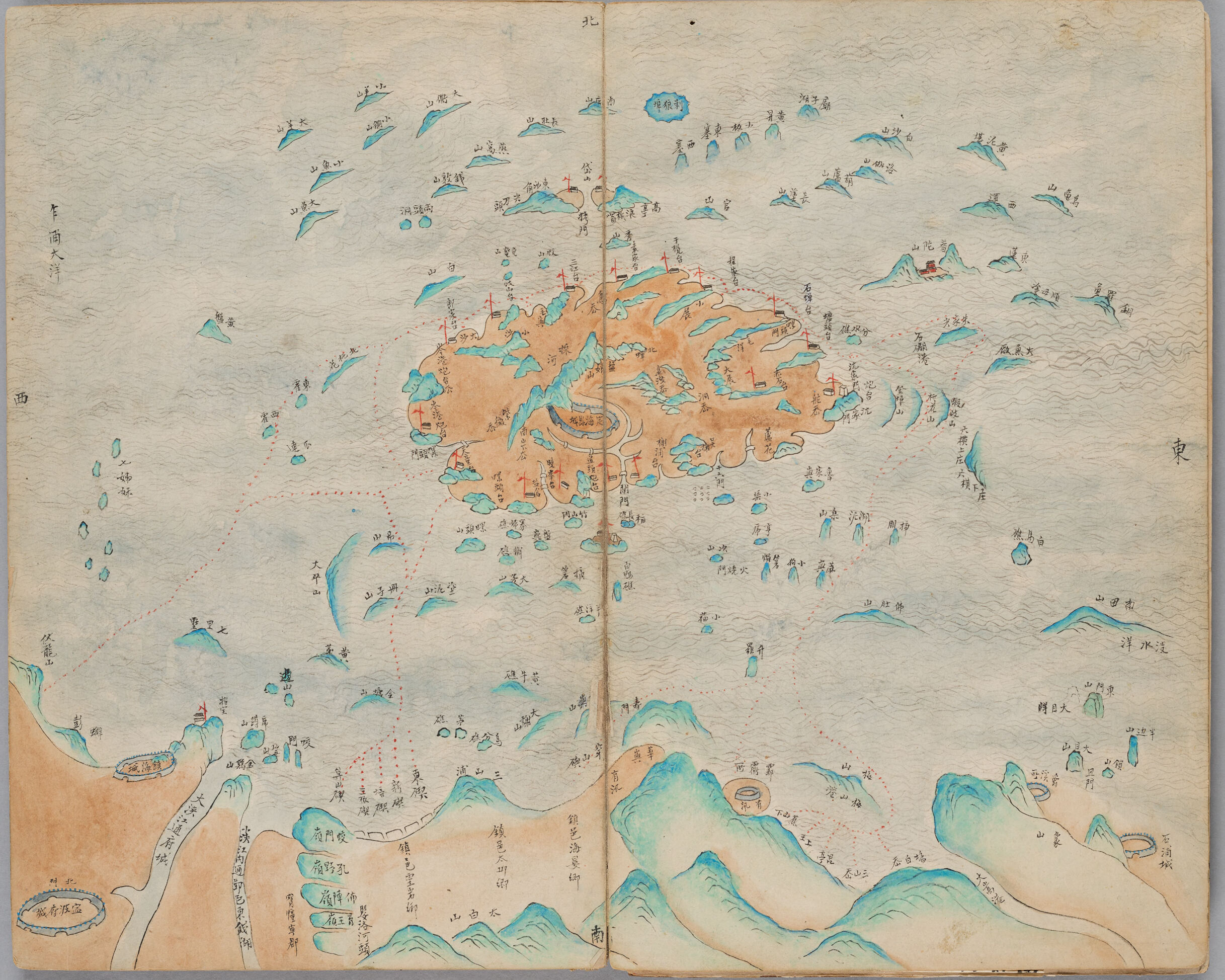
This image features a two-page spread of a traditional East Asian-style map, likely to be of Japanese origin given the style and script which appears to be kanji characters. The map is hand-drawn and colored, depicting what seems to be an archipelago with a larger landmass in the center, surrounded by numerous smaller islands. The sea is represented with stylized wavy lines, and the land features are rendered in shades of brown and green, with mountain ranges and peaks prominent on the larger islands. There are red dotted lines that might suggest routes or important pathways, possibly maritime routes. Each island and significant feature has labels written in the aforementioned script. The colors are somewhat faded, indicating the map's age, but it's still in relatively good condition. The overall style is reminiscent of historical East Asian cartography, which often took a more artistic approach to mapping, as opposed to the strictly geometric style of Western cartography from the same eras.
Created by gpt-4o-2024-05-13 on 2025-01-02
This image depicts a historical, hand-drawn map featuring an archipelago with numerous islands surrounded by an expansive sea. The largest island or land mass is centrally located and is colored in a reddish-brown hue, possibly to indicate elevation or significance. Smaller islands, mainly in blue and green tones, are dispersed throughout the surrounding waters. The map includes several annotations and inscriptions in what appears to be East Asian calligraphy, likely detailing names of islands, geographical features, and possibly routes or points of interest. Red dotted lines can be seen connecting different parts of the map, potentially indicating sailing routes or boundaries. In the bottom portion, there are prominent features like circular structures, which might represent forts or significant buildings, surrounded by mountainous terrain depicted in shades of green and blue. The placement of the map's orientation markers suggests the depicted area spans various directions, with key locations mapped out meticulously. Overall, the image conveys a detailed and artistic representation of a specific geographic region, created with a combination of cartographic precision and aesthetic embellishment.
Anthropic Claude
Created by claude-3-5-sonnet-20241022 on 2024-12-28
This is a historical Japanese map, likely from the Edo period, drawn in a traditional style with soft colors of blue and peach/orange. The map appears to show an archipelago or island cluster with various smaller islands scattered around a larger central landmass. The illustration uses traditional Japanese cartographic techniques, with mountains and coastlines depicted in a stylized manner using blue-green tints for the water and topographical features. There are numerous Japanese characters (kanji and kana) annotating different locations throughout the map. The map has a delicate, hand-painted quality with watercolor-like washes, and dotted lines appear to indicate navigation routes or administrative boundaries. The paper has a aged, cream-colored appearance typical of historical documents from this period. The map spans across two pages of what appears to be a bound book or manuscript.
Created by claude-3-haiku-20240307 on 2024-11-27
The image appears to be an old illustrated map or diagram depicting a fantastical landscape. The artwork features numerous small illustrations and detailed annotations, suggesting it may be a cartographic or geographic representation of an imaginary or mythical world. The central focus of the map appears to be a large circular structure or central hub, surrounded by an array of mountains, bodies of water, and various other geographic elements. The illustrations include depictions of what seem to be boats, buildings, and other small figures or symbols distributed throughout the landscape. The overall style and content of the image suggest it may be an ancient or historical document, possibly originating from an East Asian cultural tradition given the calligraphic text and artistic elements visible. However, without being able to identify any specific individuals or place names, I can only describe the general visual characteristics and composition of the illustration itself.
Meta Llama
Created by us.meta.llama3-2-90b-instruct-v1:0 on 2024-12-25
The image depicts an open book with a map of islands and mountains, featuring Japanese characters. The map is drawn in a style reminiscent of traditional Japanese art, with a focus on simplicity and elegance. **Key Features:** * **Map:** The map appears to be hand-drawn and features various islands and mountains, each labeled with Japanese characters. * **Color Scheme:** The map uses a muted color palette, with shades of blue, green, and brown dominating the design. * **Japanese Characters:** The map includes numerous Japanese characters, which are likely used to identify specific locations or provide additional information about the area. * **Book:** The map is presented in an open book format, suggesting that it may be part of a larger collection or atlas. **Overall Impression:** The image presents a beautiful and intricate map that showcases the artistic style of traditional Japanese cartography. The use of Japanese characters adds an element of cultural significance, making the map a valuable resource for those interested in Japanese history and geography.
Created by us.meta.llama3-2-11b-instruct-v1:0 on 2024-11-23
The image presents a map of an island, likely from the 17th or 18th century, showcasing a unique blend of traditional Chinese and Japanese artistic styles. The map is rendered on two pages of a book, with the left page featuring a larger section of the island and the right page displaying a smaller portion. **Key Features:** * **Map Design:** The map is drawn in a style reminiscent of traditional Chinese and Japanese art, characterized by bold lines, vibrant colors, and intricate details. * **Island Layout:** The island is depicted as a large, irregularly shaped landmass with numerous smaller islands and islets surrounding it. The main island is divided into several distinct regions, each with its own unique features and markings. * **Water Features:** The map includes various water features, such as rivers, lakes, and bays, which are depicted in shades of blue and green. These features are likely intended to represent the island's geography and topography. * **Landmarks:** Several landmarks are marked on the map, including mountains, forests, and settlements. These landmarks are represented by symbols and abbreviations, which may be difficult to decipher without further context. * **Writing:** The map includes various forms of writing, including Chinese characters and Japanese kanji. These inscriptions provide additional information about the island and its features, but their meaning may be lost to time. * **Color Scheme:** The map features a muted color palette, with shades of brown, beige, and gray dominating the design. The use of these colors creates a sense of age and wear, suggesting that the map has been handled and studied extensively over the years. * **Condition:** The map appears to be in good condition, with some signs of aging and wear. The pages are yellowed and creased, and there are small tears and holes throughout. Despite these imperfections, the map remains a valuable and fascinating artifact. **Conclusion:** This map provides a unique glimpse into the geography and culture of an island from the 17th or 18th century. Its intricate design and colorful illustrations make it a beautiful and informative piece of art. While the meaning of some of the inscriptions and symbols may be lost to time, the map remains a valuable resource for historians and scholars interested in the history of cartography and cultural exchange.
Amazon Nova
Created by amazon.nova-lite-v1:0 on 2025-01-04
The image shows a detailed hand-drawn map with a predominantly blue and brown color palette. The map appears to be a historical document, likely from the Edo period in Japan, as indicated by the traditional Japanese writing. The map features various islands, each marked with names in Japanese characters. The central island is larger and more detailed, possibly indicating its significance. The map also includes a compass rose in the upper right corner, and there are several notes and annotations in Japanese, suggesting the map was used for navigation or geographical study.
Created by amazon.nova-pro-v1:0 on 2025-01-04
The image depicts a vintage map that appears to be a part of an old book. The map is divided into two sections by a vertical line, with the left side featuring a larger landmass and the right side showcasing a smaller one. The landmasses are depicted in a light brown color, while the water bodies are represented in blue. The map includes various geographical features, such as mountains, rivers, and islands, all labeled in a foreign language.
Text analysis
Amazon