Machine Generated Data
Tags
Color Analysis
Categories
Imagga
| text visuals | 99.5% | |
Captions
Microsoft
created on 2019-06-05
| a close up of a map | 61.4% | |
| close up of a map | 57% | |
| a close up of text on a map | 47.9% | |
Clarifai
created by general-english-image-caption-blip on 2025-05-04
| a photograph of a plan of a plan of a plan of a plan of a plan of a | -100% | |
Google Gemini
Created by gemini-2.0-flash-lite on 2025-05-03
Here is a description of the image:
Overall:
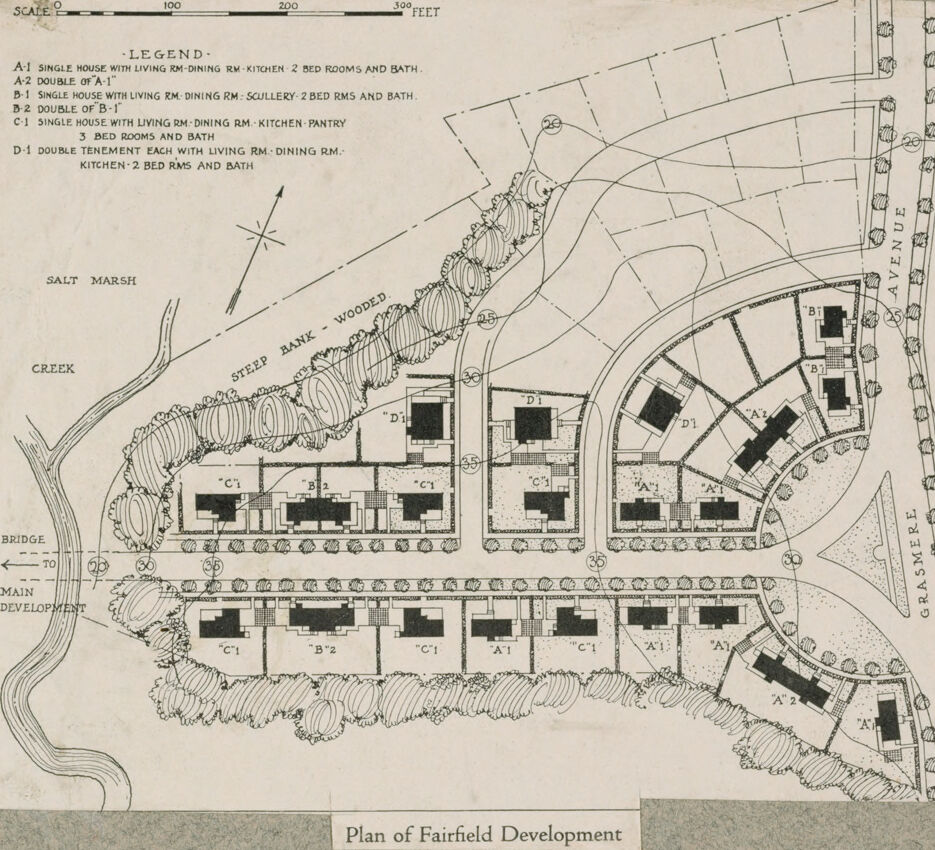
The image is an architectural plan of a housing development called "Fairfield Development." It is a black and white drawing with labeled buildings, roads, and natural features.
Key Features:
- Layout: The development features a semi-circular street layout, with buildings arranged along curved roads. There's a main road that leads into the development, a bridge to a "main development" and an avenue named "Grasmere" on the right.
- Buildings: The plan shows different types of houses, each labeled with a letter and number code (e.g., "A-1", "B-2", "C-1"). There are single houses (A-1, B-1, C-1) and doubles (A-2, B-2, D-1). Each building type corresponds to the legend that specifies the rooms and features.
- Natural Features: The plan includes a "Salt Marsh," "Creek," and "Steep Bank - Wooded" area, indicating the integration of natural landscape into the development.
- Legend: A legend at the top left explains the building types (A-1, A-2, B-1, B-2, C-1, and D-1), including the number of bedrooms, kitchens, living/dining rooms, etc.
- Scale: A scale bar is provided at the top, allowing for size estimation.
- Roads and Paths: The plan includes roads and possibly walkways, and lines suggesting the contour of the land.
- Text and Labels: The plan has various labels such as "Bridge," "Main Development," and street names like "Grasmere Avenue."
Style and Context:
The drawing style appears to be from an earlier era. It is a professional architectural or planning plan intended to provide visual representation and guidance for the development.
Created by gemini-2.0-flash on 2025-05-03
Here's a description of the image:
The image is a plan or blueprint of a housing development labeled "Plan of Fairfield Development". It's a black and white drawing, likely from an older document. The scale is indicated at the top, ranging from 0 to 300 feet. A legend is provided, detailing the different types of houses in the development, labeled as A-1, A-2, B-1, B-2, C-1, and D-1. Each type is described with its layout of rooms and number of bedrooms and baths.
The drawing shows the arrangement of houses along streets. Several streets have numbers labeled along them. Along the right side is a road labeled Grasmer Avenue. The housing development borders on one side by Salt Marsh Creek. The drawing also indicates a steep wooded bank and a bridge leading to the main development.
Text analysis
Amazon