Machine Generated Data
Tags
Color Analysis
Categories
Imagga
| text visuals | 99.6% | |
Captions
Microsoft
created by unknown on 2019-06-05
| a close up of a map | 80.5% | |
| close up of a map | 77.5% | |
| a map with text | 68.5% | |
Clarifai
created by general-english-image-caption-blip on 2025-05-29
| a photograph of a map of a map of a city | -100% | |
Meta Llama
Created by us.meta.llama3-2-11b-instruct-v1:0 on 2025-05-26
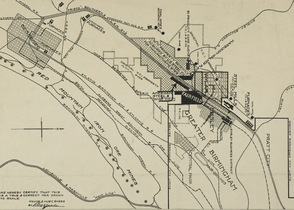
The image presents a detailed map of the Fairfield, Alabama area, showcasing various industrial and residential areas. The map is rendered in black ink on a beige background, with a compass rose in the bottom-left corner indicating the orientation of the map.
Key Features:
- Industrial Areas:
- Coal Mines
- Steel Mills
- Furnaces
- Iron Ore Mines
- Mines
- Residential Areas:
- Fairfield
- Greater Fairfield
- Birmingham
- Pratt City
- Transportation:
- Railroad tracks
- Roads
- Other Features:
- Parks
- Rivers
Visual Representation:
The map provides a comprehensive overview of the Fairfield area, highlighting the industrial and residential sectors, as well as the transportation infrastructure. The use of black ink on a beige background creates a clear and legible visual representation of the area.
Conclusion:
The map of Fairfield, Alabama, provides a detailed and informative visual representation of the area's industrial and residential sectors, as well as its transportation infrastructure. The map is a valuable resource for anyone looking to understand the layout and features of the area.
Created by us.meta.llama3-2-90b-instruct-v1:0 on 2025-05-26
This image depicts a map of Birmingham, Alabama, with a focus on the Fairfield area. The map is rendered in black and white, featuring a beige background with black lines and text. It appears to be a vintage map, likely created in the early 20th century.
The map showcases various landmarks, including roads, railroads, mines, furnaces, and other industrial facilities. Notable features include the American Steel & Wire Co., the Birmingham Ore Mines, and the Red Mountain. The map also highlights the location of the Greater Birmingham Fair Grounds and the Ensley Business District.
In the bottom-left corner, a certification statement reads, "We hereby certify that this is a true & correct map drawn to scale." This suggests that the map was intended for official or professional use, possibly for urban planning or development purposes.
Overall, this map provides a fascinating glimpse into the industrial and economic landscape of Birmingham during its early years as a major steel-producing city.
Amazon Nova
Created by amazon.nova-pro-v1:0 on 2025-05-25
The image is a map of the area around Fairfield, Alabama, as it was in 1916. The map is drawn to scale and is certified as accurate by Meade and Huey, engineers. It shows the layout of the town, including streets, buildings, and other features. The map is divided into two sections, with the upper section showing the area around Fairfield and the lower section showing the surrounding area. The map includes labels for various streets, buildings, and other features, as well as a compass rose indicating the direction of north. The map also includes a legend explaining the symbols used on the map. Overall, the map provides a detailed view of the layout of Fairfield and the surrounding area in 1916.
Created by amazon.nova-lite-v1:0 on 2025-05-25
This image is a vintage map of the Birmingham District, featuring a detailed layout of the area's industrial and transportation infrastructure. The map includes various labeled landmarks, such as "Fairfield," "Central Park," "Birmingham," and "Pratt City." It also shows the location of different factories, furnaces, and mines, with some of them marked with symbols. The map is accompanied by a certification statement, indicating that it is a true and correct map drawn to scale. The overall design of the map is reminiscent of historical maps, with a sepia-toned background and intricate line work.
Google Gemini
Created by gemini-2.0-flash-lite on 2025-05-22
This is a detailed map of an industrial region, likely dating from the early 20th century, based on the map's style and the businesses and infrastructure it depicts. Here's a breakdown:
Key Features & Industries:
- Location: The map depicts a region centered around Birmingham, Alabama, with surrounding areas like Bessemer, Fairfield, and Pratt City.
- Iron and Steel Production: The primary industry highlighted is iron and steel production. This is evident from:
- The numerous furnaces shown, crucial for smelting iron ore.
- Steel Mills that process the iron.
- Coal Mines and Coke Ovens, indicating the presence of coal mining (necessary for the iron and steel process).
- The label "Iron Ore Mines" and the "Red Mountain".
- "American Steel & Wire Co"
- Railroads: A network of railroads is prominently featured, including:
- "Southern"
- "Frisco"
- "Louisville & Nashville"
- "Atlanta Birmingham and Great Southern Railroad"
- "Birmingham Mineral Railroad".
Geographic Features:
- Red Mountain: A defining topographical element where iron ore was mined.
- City Limits: Outlines the boundaries of the incorporated areas like Birmingham, Pratt City, etc.
- Central Park: The presence of a park suggests the area has some urban amenities.
- Fair Grounds
Businesses and Companies:
- US Steel Co is mentioned which indicates the major player in the iron and steel sector at the time.
- Harbison Walker Plan, which may have been a brick production facility.
- American Steel & Wire Co.
Map Details:
- Scale: The map indicates it is "drawn to scale," suggesting accuracy in the relative sizes and distances between features.
- Author and Certification: The map was created by "Meade & Huey, Engrs." and includes a certification of accuracy, reinforcing its value as a historical document.
- Style: The map's style is characteristic of early 20th-century cartography with the use of symbols, hand lettering, and distinct lines to represent the various features.
In summary, this map is a valuable historical snapshot of a highly industrialized area, specifically focused on iron and steel manufacturing and the associated infrastructure (mines, railroads, etc.). It shows the spatial relationships between businesses, industrial sites, and the urban landscape of Birmingham and its surrounding areas during a period of significant industrial growth.
Created by gemini-2.0-flash on 2025-05-22
Here's a description of the image based on the information provided:
Overall:
The image appears to be a map or diagram depicting industrial infrastructure and geographical features of an area. It's likely a historical or technical map due to its style and content. The map uses a combination of lines, text labels, and shaded or textured areas to represent different features.
Key Features:
- Industrial Facilities: The map prominently features various industrial facilities, especially furnaces and steel mills.
- Transportation: Railroad lines and their names are a dominant aspect, connecting the different industrial sites and possibly indicating transportation routes for materials.
- Geographic Features: A "Red Mountain" and references to ore mines suggests a landscape rich in mineral resources.
- Cities and Towns: The map labels "Bessemer," "Fairfield," "Birmingham" and "Pratt City" with their approximate locations.
- Labels: Many labels on the map denote companies, railway lines, and specific areas like "Central Park", etc.
- Property: The map shows a property recently acquired by U.S. Steel Co. for manufacturing sites.
Signature
- The map certifies that it is a true and correct map drawn to scale by Meade & Huey, Engrs.
BY.
Overall Impression:
The map is a snapshot of an industrial landscape, likely from a time when iron ore mining and steel production were major industries in the region. It highlights the infrastructure and resources that supported these industries.
Mistral Pixtral
Created by us.mistral.pixtral-large-2502-v1:0 on 2025-05-27
The image is a detailed black-and-white map of the Greater Birmingham area, specifically focusing on Fairfield and its surrounding regions. The map includes various industrial sites, railroads, and geographical features. Here are some key elements:
Industrial Sites:
- The map highlights several furnaces, steel mills, and ore mines, indicating a significant industrial presence.
- Notable locations include Woodward Iron Co., Sloss-Sheffield Steel & Iron Co., Tennessee Coal, Iron & Railroad Co. (T.C.I.), and Republic Steel Corp.
Railroads:
- The map shows multiple railroad lines crisscrossing the area, connecting different industrial sites.
- The Southern Railway and the Louisville & Nashville Railroad are prominently featured.
Geographical Features:
- Red Mountain is a significant landmark, running diagonally across the map.
- The map also indicates the locations of ore mines along Red Mountain.
Cities and Towns:
- The map includes the cities of Birmingham, Fairfield, and other smaller towns and communities.
- Specific areas like Ensley, Pratt City, and Edgewater are also marked.
Other Features:
- The map includes labels for various properties, such as the Birmingham Baseball Park and the Fairgrounds.
- There are also indications of residential areas and other landmarks.
Scale and Orientation:
- The map includes a scale and a compass rose for orientation, indicating that north is towards the top of the map.
Certification:
- There is a note at the bottom left certifying that the map is true and correct, signed by Mead & Huey Engineers and dated October 1926.
This map provides a comprehensive overview of the industrial and geographical layout of the Greater Birmingham area during the mid-1920s.
Text analysis
Amazon