Machine Generated Data
Tags
Clarifai
created on 2019-06-05
| illustration | 97 | |
|
| ||
| desktop | 95.7 | |
|
| ||
| vector | 94.8 | |
|
| ||
| symbol | 91.5 | |
|
| ||
| design | 91.3 | |
|
| ||
| decoration | 89.4 | |
|
| ||
| vintage | 89.2 | |
|
| ||
| graphic | 89.1 | |
|
| ||
| retro | 88.5 | |
|
| ||
| margin | 88 | |
|
| ||
| art | 87.9 | |
|
| ||
| paper | 87.9 | |
|
| ||
| abstract | 85.5 | |
|
| ||
| pattern | 84.6 | |
|
| ||
| card | 84.4 | |
|
| ||
| picture frame | 84.2 | |
|
| ||
| old | 83.7 | |
|
| ||
| image | 82.2 | |
|
| ||
| invitation | 80.7 | |
|
| ||
| chalk out | 79.8 | |
|
| ||
Imagga
created on 2019-06-05
Microsoft
created on 2019-06-05
| handwriting | 98 | |
|
| ||
| text | 74.8 | |
|
| ||
| rectangle | 53.5 | |
|
| ||
| plaque | 21.4 | |
|
| ||
Color Analysis
Categories
Imagga
| paintings art | 99.5% | |
|
| ||
Captions
Microsoft
created on 2019-06-05
| a close up of a piece of paper | 60% | |
|
| ||
| a piece of paper | 59.9% | |
|
| ||
| a close up of a logo | 59.8% | |
|
| ||
Clarifai
created by general-english-image-caption-blip on 2025-05-03
| a photograph of a map of a map of a map of a city | -100% | |
|
| ||
Google Gemini
Created by gemini-2.0-flash-lite on 2025-05-04
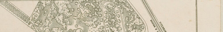
This is a detailed black and white map of the McLean Hospital Grounds. The map uses various artistic techniques to depict the landscape and buildings, including the use of hatching and stippling to represent trees, bushes, and the varying topography.
Here's a breakdown:
- Central Focus: The main part of the map showcases the hospital buildings. They are depicted in a solid black, with each structure labeled with a letter from an index below. The buildings are clustered together and interconnected by winding roads.
- Landscape: The surrounding terrain is detailed, including undulating hills, patches of trees, and other elements of the landscape. The trees and bushes are rendered with hatching or stippling, and the hills are defined with contour lines.
- Surrounding Areas: The map shows the surrounding areas, including streets and the Boston & Maine Railroad tracks.
- Key & Index: Below the map, there's an index labeling each letter with the name of the buildings or areas within the grounds. Also, there is a scale of feet, which helps to understand the relative distances on the map.
- Title: The title "Mc. LEAN HOSPITAL GROUNDS" is printed in a bold font at the top of the map, indicating its purpose.
The map appears to be a historical representation, likely created to illustrate the layout and key features of the hospital campus during its development or operation. The style suggests it may have been an engineering or architectural drawing.
Created by gemini-2.0-flash on 2025-05-04
Here's a description of the image you provided:
The image is a vintage map or plan of the McLean Hospital grounds. It's drawn in a detailed, illustrative style. Key elements include:
- Grounds Layout: The central area of the map features the buildings of McLean Hospital. The buildings are labeled with letters that correspond to an index at the bottom of the image. The grounds around the buildings are landscaped with trees, roads, and pathways.
- Surrounding Area: Around the hospital grounds, the map shows the surrounding infrastructure, including the "Concord Turnpike" to the northwest and the "Boston & Maine Fitchburg R.R." (railroad) to the northeast. There are also labeled streets and the "Waverley Station."
- Index: An index at the bottom lists what each letter on the map represents, for example, "A, Administration House", "B, Upham", and so on.
- Scale: There is a scale indicating the number of feet.
- Title: The title "Mc. LEAN HOSPITAL GROUNDS" is prominently displayed.
In general, the map seems to be created for informational or planning purposes.
Text analysis