Machine Generated Data
Tags
Color Analysis
Feature analysis
Amazon
| Airplane | 70.8% | |
Categories
Imagga
| paintings art | 51.1% | |
| text visuals | 39% | |
| interior objects | 7.2% | |
| food drinks | 2% | |
Captions
Microsoft
created on 2018-12-21
| an old photo of a computer | 49% | |
| a close up of text on a white surface | 48.9% | |
| a black and white photo of a computer | 40.4% | |
OpenAI GPT
Created by gpt-4 on 2025-03-06
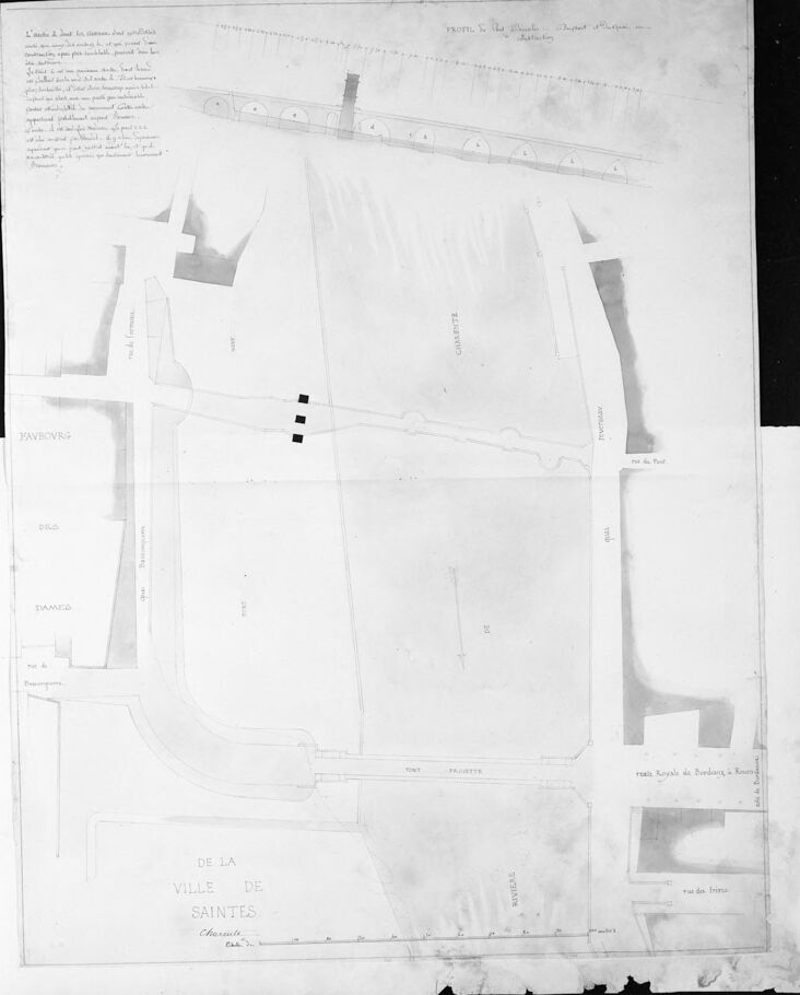
The image appears to be a photograph of an old architectural plan or map. It is presented in black and white or grayscale, which may be due to its age or the method of photography. The map displays a layout of streets and blocks, with certain areas and streets labeled, although the text is not entirely legible in this view. On the map, some buildings and their shapes can be inferred, and different sections of the map have various annotations and markings.
At the bottom of the image, there is a clear title "DE LA VILLE DE SAINTES" followed by text that is less clear, which might indicate the name of the architect, the year of the map, or other identifying details pertaining to the origins of this document. The paper is damaged at the edges, particularly along the bottom where it appears torn, suggesting that the document is fragile and has undergone wear over time.
The image also contains horizontal and vertical creases, indicating the map has been folded at some point. The overall condition of the paper, the style of the handwriting, and the nature of the drawing give the impression that it is quite old and may be of historical significance.
Created by gpt-4o-2024-05-13 on 2025-03-06
The image appears to be an old architectural or urban planning map, probably hand-drawn, featuring a detailed layout of an area or section of a town. In the upper part of the map, there are detailed sections showing what looks like a series of structures, possibly arches or vaulted constructions.
On the left side of the map, various street names such as "Rue d'Artois" and "Rue d'Orléans" are indicated. At the bottom, it reads "De la Ville de Saintes," which indicates that this might be a map of a part of the town of Saintes. There are several annotations and handwritten notes in French around the perimeter of the map.
The central area of the map includes detailed streets and plot layouts but some sections appear faded or washed out, possibly due to age. The overall orientation includes a compass direction marking "N" pointing towards the top right corner, indicating the north. The map overall seems to be a historical document detailing the urban layout of a part of Saintes.
Anthropic Claude
Created by claude-3-haiku-20240307 on 2025-03-04
The image appears to be an architectural or engineering diagram or blueprint. It shows various geometric shapes, lines, and labels that seem to represent different structural elements or parts of a building or construction project. The diagram is titled "De la ville de saintes", indicating it is related to the town of Saintes, but I do not see any human figures or faces in the image.
Created by claude-3-opus-20240229 on 2025-03-04
The image shows an old, handwritten architectural plan or map of what appears to be a church or religious building called "De La Ville De Sainte". The plan outlines the layout and dimensions of the structure, including notations for walls, openings, and architectural elements. At the top, there is additional handwritten text providing more details or notes about the building, though it is difficult to read clearly in this image resolution. The overall style of the drawing and handwriting suggests this is a historical document, likely from the 18th or 19th century.
Created by claude-3-5-sonnet-20241022 on 2025-03-04
This appears to be an architectural or city planning map titled "DE LA VILLE DE SAINTES" (Of the City of Saintes), which appears to be referencing Saintes, a city in France. The image is a black and white drawing or plan showing various streets, blocks, and buildings in what seems to be a section of the city. At the top of the image, there appears to be some handwritten notes or annotations, and there's a diagram showing what might be a cross-section or elevation view with several circular elements arranged in a line. The map itself shows various geometric shapes representing different structures or parcels of land, with clear delineation of streets and pathways. The document appears to be somewhat aged or historical in nature, given its style and presentation.
Meta Llama
Created by us.meta.llama3-2-11b-instruct-v1:0 on 2025-03-13
The image depicts a black-and-white map of a city, with the title "De La Ville de Saintes" at the bottom. The map is divided into sections, each labeled with a different name, such as "Paveurs," "Eglise," and "Rue de Bourgogne." There are also several symbols and markings on the map, including what appears to be a church or other building, as well as various lines and shapes that may represent streets, buildings, or other features.
The map appears to be hand-drawn, with some areas filled in with shading or hatching to indicate different types of terrain or features. The overall effect is one of a detailed and informative map that provides a clear picture of the city's layout and geography.
The map is likely a historical document, given its age and the fact that it is written in French. It may have been created for use by city planners, architects, or other officials who needed to understand the layout of the city and its various features. Alternatively, it could be a personal map created by someone who lived in or visited the city and wanted to record its layout for their own reference.
Overall, the map provides a fascinating glimpse into the history and geography of the city of Saintes, and its detailed depiction of the city's layout and features makes it a valuable resource for anyone interested in the subject.
Created by us.meta.llama3-2-90b-instruct-v1:0 on 2025-03-13
The image depicts a black-and-white map of a city or town, with the title "DE LA VILLE DE SAINTES" written in the bottom-left corner. The map appears to be hand-drawn and features various buildings, roads, and other structures.
In the top-left corner, there is a section of text that is too small to read, but it may provide additional information about the map or its context. The map itself is divided into different sections, each with its own unique features and labels.
Overall, the image suggests that this is an old map of the city of Saintes, possibly from the 18th or 19th century. It provides a glimpse into the layout and architecture of the city during that time period.
Amazon Nova
Created by amazon.nova-pro-v1:0 on 2025-01-13
The image is a black-and-white architectural plan or map of an area, possibly a city or town. The document is titled "VILLE DE SAINTES," suggesting it is a plan for the city of Saintes. The plan is divided into sections with various labels and measurements, indicating different parts of the city or specific structures. The layout includes streets, buildings, and other urban elements, with some areas highlighted or marked for emphasis. The document appears to be an official or technical drawing, likely used for urban planning or architectural purposes.
Created by amazon.nova-lite-v1:0 on 2025-01-13
This image is a map of the town of Saintes, France, drawn in 1775 by P.M. de la Ville de Saintes. The map is in black and white and features a detailed layout of the town's streets, buildings, and other landmarks. The map includes a key or legend in the bottom left corner, which provides information about the various symbols and markings used on the map. The map also includes a scale in the bottom right corner, which indicates the distance between different points on the map. The map is a valuable historical document that provides insight into the layout and development of the town of Saintes during the 18th century.
Text analysis
Amazon