Machine Generated Data
Tags
Color Analysis
Feature analysis
Amazon
| Rug | 84.7% | |
Categories
Imagga
| paintings art | 85.4% | |
| streetview architecture | 14.1% | |
Captions
Microsoft
created on 2020-05-02
| a close up of a screen | 46% | |
| a screen shot of a computer | 35.4% | |
| a screen shot of a window | 34.7% | |
OpenAI GPT
Created by gpt-4 on 2025-03-06
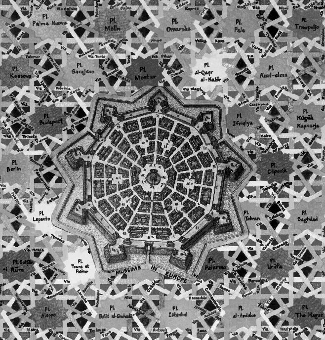
The image depicts a framed black-and-white illustration or map, representing a fortified city with a central star-shaped structure. Around this central structure are numerous geometric shapes and patterns that seem to resemble a patchwork of fields or urban blocks. Interspersed throughout the patterned area are labels with names that appear to be places, perhaps streets or notable locations, with names like "Sarajevo," "Berlin," "Palermo," and "Tehran," suggesting a mix of European and Middle Eastern cities.
The center of the illustration features a polygonal (most likely hexagonal) fortification with radial streets creating a strong geometric pattern, typical of planned Renaissance cities or star forts designed for defensive purposes. These fortresses were common in Europe from the 15th to 18th centuries, constructed with angular bastions to better deflect cannon fire and provide overlapping fields of fire for defenders.
The inset at the bottom of the image reads "MUSLIMS IN EUROPE," which seems to indicate a thematic focus for the illustration, possibly exploring the historical presence and influence of Muslim culture and peoples in European cities. The artwork has a very structured layout giving an almost abstract representation of urban planning or historical cartography.
Created by gpt-4o-2024-05-13 on 2025-03-06
The image depicts a detailed, stylized map or plan of an intricate, star-shaped fortress or city layout prominently positioned in the center. The central structure is enclosed by intricately laid out pathways and sections that resemble bastions or fortifications typical of historical military architecture. The map is further divided into multiple labeled sections or sectors. Surrounding this central star-shaped structure are various names and terms (e.g., P.I. Berlin, P.I. Baghdad, P.I. Palma Nova) indicating place names, which are distributed in a pattern reminiscent of an urban grid or network.
The design appears almost labyrinthine, with dense clusters of names and places creating a complex mosaic around the central fortress layout. The names could possibly refer to historical or geographical locations, and the entire image may represent a metaphoric or conceptual map rather than an actual geographic location. The text "MUSEUMS IN EUROPE" appears at the bottom center, suggesting the map might be related to museum exhibits or collections in Europe, perhaps illustrating their distribution or interconnectedness.
Anthropic Claude
Created by claude-3-haiku-20240307 on 2025-03-04
The image appears to be a detailed architectural map or plan of a fortified city or settlement. The central part of the image depicts a radial, star-shaped layout with what seems to be a central structure or landmark. Surrounding this central design are numerous smaller geographic labels, likely indicating the names of various neighborhoods, districts, or other locations within the larger settlement. The overall aesthetic has a geometric, almost abstract quality, with a strong emphasis on the intricate web of streets and pathways connecting the different areas.
Created by claude-3-opus-20240229 on 2025-03-04
The image shows an aerial view map of a star-shaped fortification or citadel surrounded by walls with bastions at the points. The map labels various parts of the fortification, such as the Palma house, Mella, Omarska, Pele, Trojanije, Sarkon, and others. The fortress appears to have a central core with radiating walls forming the star shape, and numerous smaller structures within the walls. The map has an intricate geometric pattern created by the overlapping angular walls and bastions. It provides a detailed layout of this historical defensive structure.
Created by claude-3-5-sonnet-20241022 on 2025-03-04
This image appears to be a historical map or architectural plan showing a star-shaped fortified city design, typical of Renaissance military architecture. The central part of the design shows an octagonal or circular city layout with radiating streets emerging from a central point, surrounded by defensive walls and bastions in a star pattern. Around this central fortress, there's a pattern of street layouts with various place names written in, including references to locations like Baghdad, Istanbul, Budapest, and other cities. The overall design combines geometric precision in the center with a more organic-looking network of pathways and places in the surrounding areas. The map is in black and white and appears to be a historical document or artistic representation of an ideal city plan.
Meta Llama
Created by us.meta.llama3-2-11b-instruct-v1:0 on 2025-03-12
The image presents a black-and-white map of a city, showcasing its layout and various landmarks. The map is surrounded by a white border, which adds a touch of elegance to the overall design.
Here are the key features of the map:
- Map Design:
- The map is presented in a square format, with a clear and concise layout.
- The city's streets and buildings are depicted in a detailed manner, with clear labels and markings.
- City Layout:
- The city appears to be a walled city, with a central square or plaza surrounded by buildings and streets.
- The streets are arranged in a grid-like pattern, with some streets branching off in different directions.
- Landmarks:
- Several landmarks are visible on the map, including churches, mosques, and other important buildings.
- Some of these landmarks are labeled with their names, while others are not.
- Surrounding Area:
- The surrounding area of the city is depicted in a lighter shade of gray, indicating that it is not as densely populated as the city center.
- There are no notable landmarks or features visible in the surrounding area.
In summary, the image presents a detailed map of a city, showcasing its layout and various landmarks. The map is well-designed and easy to read, making it a useful tool for navigation or planning.
Created by us.meta.llama3-2-90b-instruct-v1:0 on 2025-03-12
The image is a black and white map of a city, with a central star-shaped structure surrounded by a grid of streets and buildings. The map appears to be hand-drawn or illustrated, with intricate details and labels in various languages.
Key Features:
- Central Star-Shaped Structure: The central feature of the map is a star-shaped structure with eight points, resembling a compass rose. It is labeled "EUROPE" at the bottom and "IN MUSLIMS" at the top.
- Grid of Streets and Buildings: Surrounding the central structure is a grid of streets and buildings, with each block labeled with a name or number. The streets are depicted as straight lines, while the buildings are represented by small rectangles or squares.
- Labels and Inscriptions: Throughout the map, there are numerous labels and inscriptions in various languages, including Arabic, Turkish, and possibly other languages. These labels appear to identify specific locations, landmarks, or features within the city.
- Border and Frame: The map is surrounded by a white border, which is framed by a thin black line. The border is slightly thicker at the top and bottom than at the sides.
Overall Impression:
The image presents a detailed and intricate map of a city, with a unique central structure and a complex network of streets and buildings. The use of multiple languages and labels suggests that the map may be intended for an international audience or for educational purposes. The overall design and layout of the map are visually appealing and suggest a high level of craftsmanship or artistry.
Amazon Nova
Created by amazon.nova-lite-v1:0 on 2025-01-12
The image is a map of the city of Fez, Morocco, created by the artist and architect Hassan Fathy. The map is divided into several sections, each representing a different part of the city. The central section of the map shows the city's medina, or old town, with its narrow winding streets and intricate patterns of buildings. The surrounding sections of the map show the city's suburbs and other areas, with different patterns and layouts.
The map is drawn in black and white, with the buildings and streets represented by simple geometric shapes. The map is framed in a white border, and the text is written in Arabic. The map is a detailed and intricate representation of the city of Fez, showing the complex layout of its streets and buildings.
The image is a black and white photograph of the map, which is displayed on a white background. The photograph is taken from a low angle, giving the viewer a sense of the map's scale and detail. The photograph is a reproduction of the original map, which was created by Hassan Fathy in the 1950s.
Created by amazon.nova-pro-v1:0 on 2025-01-12
The image shows a black-and-white illustration of a star-shaped map with the names of cities and countries. The star-shaped map has a total of 16 points. The names of the cities and countries are written in the center of each point of the star. The names of the cities and countries are written in different languages. The names of the cities and countries are written in a cursive font.
Text analysis
Amazon