Machine Generated Data
Tags
Color Analysis
Feature analysis
Amazon

| Person | 66.2% | |


Categories
Imagga
| paintings art | 62% | |
| beaches seaside | 22% | |
| streetview architecture | 15.4% | |
Captions
Microsoft
created on 2019-08-08
| a vintage photo of a person | 77.4% | |
| a vintage photo of some text | 77.3% | |
| an old photo of a person | 77% | |
OpenAI GPT
Created by gpt-4o-2024-05-13 on 2025-02-09
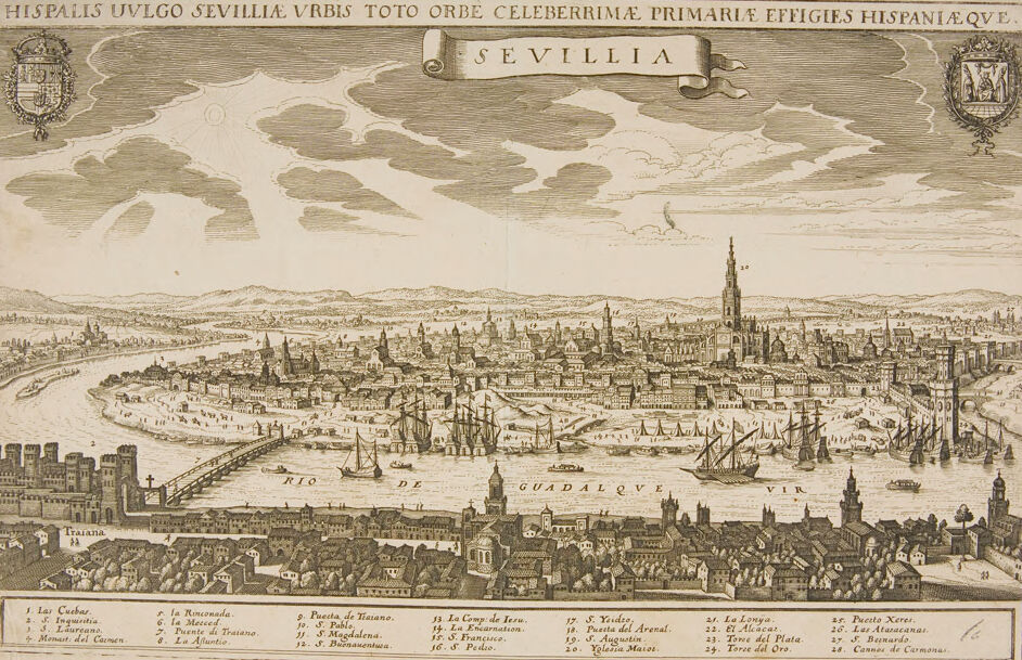
The image is a detailed historical engraving of the city of Seville, Spain, as seen from an elevated perspective. The engraving is titled "SEVILLIA" and includes a Latin phrase at the top: "HISPALIS VULGO SEVILLIAE URBIS TOTO ORB CELEBERRIMAE PRIMARIAE EFFIGIES HISPANIAEQVE," which translates to "Hispalis commonly known as Seville, the most renowned city in the world, the primary emblem of Spain." The engraving showcases a panoramic view of Seville, emphasizing its intricate cityscape, including various buildings, towers, and the winding path of the Guadalquivir River that flows through the city. Numerous ships are depicted sailing on the river, which indicates the city's importance as a trading and port city. Notable structures are labeled with numbers, and there is a corresponding legend at the bottom of the image providing the names of these points of interest. Some identified structures include: 1. Las Cuebas 2. Ingenio 3. Lonja 4. Monual Del Carmen 5. Intauriana 6. La Ronconada 7. La Moneda 8. Puento de Traiana 9. Puerta de Traiana 10. El Arsenal 11. La Atarazano 12. La Magdelena 13. S. Francisco 14. S. Buenaventura 15. El Anunciata 16. La Compa de Jesus 17. S. Ysider 18. S. Augustin 19. Valpar Maria 20. Puenta del Arenal 21. La Lonja 22. El Alcazar 23. Taye del Plata 24. Torre del Oro 25. Pucto Xerez 26. Lana Atarazona 27. El Pucion 28. Campos de Carmona Two coats of arms are featured at the top corners of the engraving, one on the left and one on the right. The overall style and detail suggest that this is a historical document from the early modern period, providing a visual depiction of Seville's grandeur and architectural significance during that era.
Created by gpt-4 on 2025-02-09
This image is an old, detailed engraving of the city of Seville (Sevilla in Spanish) in Spain. At the top of the image, there are two coat of arms flanking the title "SEVILLIA", with one containing an inscription "HISPALIS VULGO SEVILLIA VRBIS TOTO ORBE CELEBERRIMAE PRIMARIE EFFIGIES HISPANIAEQUE". It suggests that the image is depicting one of the most celebrated cities in the world, particularly in Spain. The view is a panoramic birds-eye perspective, showing the layout of the city with numerous buildings, churches, and other structures meticulously illustrated. The Guadalquivir River winds through the city, and there are several ships and boats on the river, highlighting its importance as a waterway. Below the main image, there is a numbered index identifying important landmarks within the city, although the text is not completely legible in this view. It indicates that the viewer can use the key to identify specific buildings and areas within the panorama. The engraving style and the dress of the few visible figures suggest that this image is several centuries old, and was likely created for historical or cartographic purposes.
Anthropic Claude
Created by claude-3-5-sonnet-20241022 on 2025-02-09
This is a historical cityscape engraving of Seville (Sevilla), Spain, likely from the 16th or 17th century. The title at the top reads "HISPALIS VULGO SEVILLIA" in Latin, referring to the city's ancient Roman name Hispalis and its modern name Sevilla. The image shows a panoramic view of the city along the Guadalquivir River. The famous Giralda tower (the cathedral's bell tower) dominates the skyline. The city is depicted with detailed architecture including numerous churches, buildings, and city walls. In the river, several sailing ships are anchored, indicating Seville's importance as a major port city during this period. The foreground shows the Triana neighborhood across the river, connected to the main city by a bridge. The image includes a numbered key at the bottom identifying various important landmarks and buildings. The drawing style is typical of medieval and early modern European city views, with a slightly elevated perspective to show the urban layout and architecture. The sky is rendered with dramatic clouds, and the surrounding countryside can be seen in the distance. This type of detailed city view was common in atlases and geographical works of the period, serving both as documentation and celebration of major European cities.
Created by claude-3-opus-20240229 on 2025-02-09
The image depicts a detailed, bird's-eye view illustration of the city of Seville, Spain in the past, likely from the 16th or 17th century based on the antique style. The intricate cityscape shows many buildings, churches, towers, walls, bridges, ships in the harbor, and surrounding countryside. A numbered key at the bottom identifies various landmarks and points of interest throughout the city. The entire illustration is presented in a vintage, engraved style with cross-hatched shading to give depth and detail. The title at the top indicates this depiction of Seville was created to celebrate its status as a primary city of the Spanish empire at that time.
Created by claude-3-haiku-20240307 on 2025-02-09
This image appears to be an engraved panoramic view of the city of Seville, Spain from the 17th century. The image is highly detailed, depicting the cityscape with numerous buildings, churches, and other landmarks along the Guadalquivir River. Ships can be seen sailing in the river, adding to the bustling and lively scene. The image is labeled "Hispalis Vulgo Sevilla Vrbs Toto Orbe Celeberrima" which means "Seville, the Renowned City Throughout All the World" in Latin. The labels on the bottom identify various parts of the city, including La Giralda, the Cathedral, and the royal alcázar palace.
Meta Llama
Created by us.meta.llama3-2-11b-instruct-v1:0 on 2025-03-15
The image is a vintage illustration of the city of Seville, Spain, titled "HISPALIS UVLGO SEVILLIA VRBIS TOTO ORBE CELEBERRIMAE PRIMARIE EFFIGIES HISPANIAE.QVE." The title is written in Latin at the top of the image. * The illustration depicts the city of Seville as it appeared in the past, with many buildings and landmarks visible. * The city is situated on the banks of the Guadalquivir River, which runs through the center of the image. * The river is lined with boats and ships, and there are several bridges crossing it. * In the background, there are hills and mountains visible, adding depth to the illustration. * The illustration also includes several symbols and emblems, such as coats of arms and banners, which are likely representative of the city's history and culture. * These symbols add to the overall sense of grandeur and importance that pervades the image. * The illustration is rendered in a detailed and intricate style, with many fine lines and textures visible. * This level of detail suggests that the illustration was created with great care and attention to accuracy. * Overall, the image provides a fascinating glimpse into the past of Seville, showcasing its rich history and cultural heritage. * It is a valuable resource for anyone interested in learning more about this beautiful city and its many attractions.
Created by us.meta.llama3-2-90b-instruct-v1:0 on 2025-03-15
This image is a vintage map of Seville, Spain, featuring a sepia-toned illustration of the city's skyline and waterfront. The map is written in Latin and Spanish, with the title "SEVILLIA" prominently displayed at the top. **Key Features:** * A large body of water dominates the center of the map, with several boats and ships visible. * The city's skyline is depicted in detail, with numerous buildings, towers, and spires visible. * A banner at the top of the map reads "HISPALIS UVLGO SEVILLIA VRBIS TOTO ORBE CELEBERRIMAE PRIMARIA EFFIGIES HISPANIAE QVE," which translates to "Seville, the most famous city in the world, the first image of Spain." * A coat of arms is located in the upper-right corner of the map, while another is situated in the upper-left corner. * A list of numbers and corresponding names is provided along the bottom edge of the map, likely indicating important landmarks or locations within the city. **Overall Impression:** This vintage map of Seville provides a unique glimpse into the city's history and architecture. The level of detail and craftsmanship that went into creating this map is impressive, making it a valuable resource for historians, researchers, and anyone interested in learning more about this beautiful city.
Amazon Nova
Created by amazon.nova-pro-v1:0 on 2025-02-09
The image depicts a city, which is Seville, Spain, with a river running through it. The river is the Guadalquivir, and it is surrounded by many buildings and structures. The city is filled with boats, and the sky is cloudy. There are also many trees and plants in the area. The image is in black and white, and it has a vintage look. The image also has a watermark in the upper left corner.
Created by amazon.nova-lite-v1:0 on 2025-02-09
The image is an antique map of Seville, Spain, drawn in 1621. The map is in black and white and shows the city of Seville with its surrounding areas, including the Guadalquivir River, which flows through the city. The map includes a list of the city's notable landmarks, such as the Giralda Tower, the Seville Cathedral, and the Alcázar Palace. The map also includes a list of the city's gates, such as the Puerta de Jerez and the Puerta de Triana. The map is framed in a decorative border with a Latin inscription that translates to "Seville, the most famous city of the whole world, the first and most noble of Spain."
Text analysis
Amazon