Machine Generated Data
Tags
Color Analysis
Feature analysis
Amazon

| Rug | 90.5% | |
Categories
Imagga
| paintings art | 100% | |
Captions
Microsoft
created on 2019-08-09
| an old photo of a clock | 27% | |
| a large clock mounted to the side | 26.9% | |
| a close up of a clock | 26.8% | |
OpenAI GPT
Created by gpt-4o-2024-05-13 on 2025-02-08
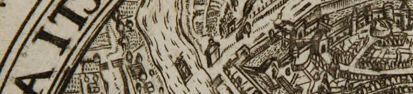
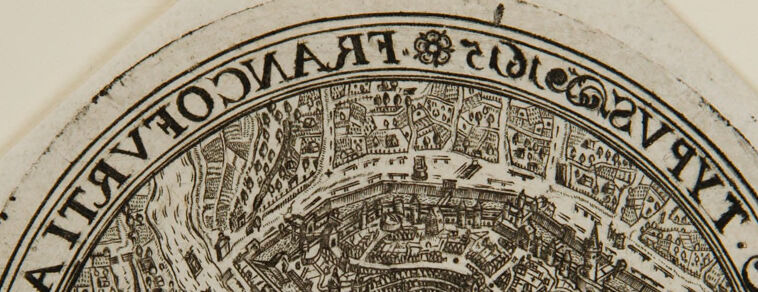
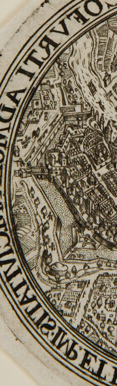
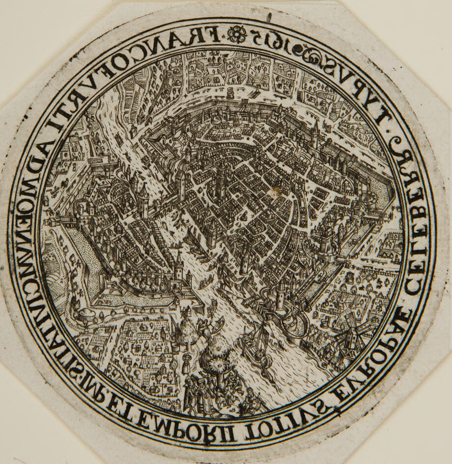
This image is an intricately detailed, circular map or illustration of a historic city, specifically Frankfurt am Main in Germany. The map appears to be an old woodcut or engraving, showcasing an aerial or bird's-eye view of the city, complete with detailed representations of buildings, streets, and landmarks. The river Main flows through the city, with bridges and possibly ships or boats depicted on it. Surrounding the inner detailed portion of the map is a border with some text written in Latin or an old European script, which includes the name of the city, "FRANCOFORT." The text around the image provides additional context, likely identifying key parts of the city or offering a descriptive narrative. Given the level of detail and style, this piece appears to be from a historical period, reflecting how cities were mapped and artistically represented in the past.
Created by gpt-4 on 2025-02-08
This image depicts an old circular map, rich in detail and displayed in a style characteristic of historical cartography. The map is printed in black ink on a light background, and it showcases an aerial view of a densely built city with numerous buildings, streets, and possibly fortifications or city walls evident within its layout. Each structure is drawn in detail, suggesting the map's intention to accurately represent the city's features. The design is compact and ornate, with shading and hatch marks indicating the three-dimensional nature of the buildings and topography. Around the rim of the circle, there's decorated text, likely the name of the city and possibly a dedication or title, but it is difficult to read without rotation, as the text follows the contour of the map's circular border and is thus oriented in different directions. The language of the text is not immediately identifiable from this perspective. The outer edges of the map appear to have some wear or discoloration, indicating it might be a historical artefact.
Anthropic Claude
Created by claude-3-5-sonnet-20241022 on 2025-02-08
This is a historical circular map or bird's eye view of what appears to be a medieval European city. The image is rendered in a detailed black and white engraving style, showing buildings, streets, and fortifications from above. A river or waterway cuts through the center of the city, and the urban layout follows a somewhat circular pattern with dense buildings and narrow streets characteristic of medieval urban planning. The map is surrounded by text in Latin script running along the circular border. The level of detail is quite impressive, showing individual buildings, towers, and city walls. This type of map, known as a plan view or bird's eye perspective, was common in the medieval and Renaissance periods to represent cities and their important landmarks. The style and execution suggest this is likely from the 16th or 17th century.
Created by claude-3-opus-20240229 on 2025-02-08
The image depicts an ornate circular map or illustration, seemingly of a historical city. The highly detailed black lines form an intricate birds-eye view of a dense urban area, with winding streets, numerous buildings, and some open spaces or plazas visible. The style suggests it portrays a medieval or early modern European city. Around the periphery of the circular illustration is text, though the resolution makes it a bit hard to read clearly. The text at the top looks like it may say "In around the tranquil city" or something similar, while the text at the bottom mentions the name of the city, though I cannot make it out with certainty from this image alone. The illustration is presented on what looks like an aged, textured paper or parchment background, giving it an antique character fitting the historical nature of the city depiction. Overall, it is a fascinating example of detailed urban cartography or panoramic illustration from an earlier era.
Created by claude-3-haiku-20240307 on 2025-02-08
The image appears to be an engraved map or plan of a city. The map features a detailed and intricate illustration of a complex urban landscape, with a central circular shape surrounded by smaller buildings, streets, and structures. The text around the edges of the image appears to be in Latin, suggesting this may be an older historical map or architectural design. The level of detail and artistry in the engraving is quite impressive, providing a detailed view of the cityscape.
Meta Llama
Created by us.meta.llama3-2-11b-instruct-v1:0 on 2025-03-13
The image presents a detailed, circular illustration of a cityscape, likely from the 16th or 17th century. The city is depicted in a bird's-eye view, showcasing its layout and various buildings. * **Circular Illustration:** * The illustration is circular in shape. * It features a detailed drawing of a city. * The city is shown in a bird's-eye view. * **Cityscape:** * The city is densely populated with buildings. * Various types of buildings are visible, including churches, houses, and possibly fortifications. * The city appears to be surrounded by a wall or fortifications. * **Text:** * The illustration includes text along the outer edge of the circle. * The text is written in an old language, possibly Latin. * The text appears to be a title or inscription, but its exact meaning is unclear. * **Background:** * The background of the image is a light beige color. * The background is plain and does not feature any additional illustrations or designs. In summary, the image presents a detailed and intricate illustration of a cityscape from the 16th or 17th century. The city is shown in a bird's-eye view, with various buildings and fortifications visible. The illustration includes text along the outer edge of the circle, which appears to be a title or inscription. The background of the image is a light beige color, providing a clean and simple contrast to the detailed illustration.
Created by us.meta.llama3-2-90b-instruct-v1:0 on 2025-03-13
The image presents a circular, black-and-white illustration of a city map, likely from the 16th century. The map is surrounded by an octagonal border with a circular inner border, featuring text in Latin. The text is written in reverse, suggesting that it was intended to be read from the back of the map. The map itself depicts a city with various buildings, roads, and waterways. It appears to be a detailed representation of a specific city, possibly Paris or another European city from the Renaissance period. The level of detail and the style of the illustration suggest that it was created by a skilled artist or cartographer. Overall, the image provides a fascinating glimpse into the cartographic techniques and artistic styles of the past. It is a valuable resource for historians, cartographers, and anyone interested in the history of urban planning and development.
Amazon Nova
Created by amazon.nova-pro-v1:0 on 2025-02-08
The image features a circular piece of paper with a detailed drawing of a city on it. The drawing is surrounded by a decorative border with text written in a foreign language. The paper is slightly worn, with some creases and discoloration, indicating that it is old. The city depicted in the drawing has many buildings, roads, and waterways, suggesting that it is a bustling urban center. The drawing is intricate and detailed, with many small details that suggest a high level of craftsmanship.
Created by amazon.nova-lite-v1:0 on 2025-02-08
The image depicts a historical map, specifically a circular woodcut print from the 16th century. The map is centered around a city, possibly Venice, given the intricate details and the presence of waterways. The map shows a detailed layout of the city, including buildings, streets, and waterways, with a focus on the central area. The text surrounding the map is in a foreign language, likely Latin, and includes phrases such as "VENETIAE" and "CELEBERRIMAE," suggesting the map's significance and the city's renown. The map is bordered by a decorative frame, adding to its historical and artistic value. The image appears to be an old print, with some wear and discoloration, indicating its age and historical importance.
Text analysis
Amazon