
Machine Generated Data
Tags
Color Analysis
Feature analysis
Amazon
| Rug | 88.3% | |
Categories
Imagga
| text visuals | 54.2% | |
| paintings art | 45.3% | |
Captions
Microsoft
created on 2021-04-03
| map | 75.2% | |
OpenAI GPT
Created by gpt-4 on 2025-02-13
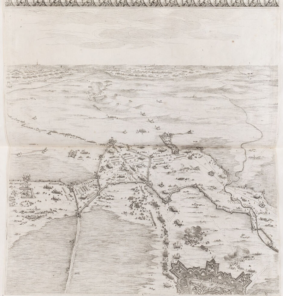
This is an old map or drawing, made in a style that suggests it's several centuries old. The drawing seems to represent a bird's-eye view of a fortified city and the surrounding area. The fortifications include walls and bastions indicating it was designed for defense. There are many labeled points of interest, likely key buildings or locations within the city, which are common in historic maps for reference purposes. The landscape outside the city includes open fields, scattered trees, and some additional buildings, which could be farms or smaller settlements. There appears to be a large body of water or a wide river to one side of the city, with ships sailing or docked, indicating the city's engagement in maritime activities. The top of the drawing contains a strip with geometric decorative patterns, typical of map borders from various historical periods. Overall, the image is rich in detail and would require further historical context to identify the specific city and time period it represents.
Created by gpt-4o-2024-05-13 on 2025-02-13
The image appears to be a historical map or illustration depicting a fortified city or town and its surrounding landscape. The drawing is highly detailed and rendered in black and white, likely created using pen and ink. Key features of the image include: 1. A fortified city with walls and ramparts prominently featured in the lower portion of the image. The fortifications have distinct, angular bastions typical of star forts. 2. There are various structures and buildings within the city walls. 3. The foreground and middle ground show the city's outlying areas with roads, rivers, and patches of woodland. 4. The landscape beyond the city extends into the background, showing fields, smaller buildings, and possibly other settlements or military encampments. 5. Various groups of people, possibly soldiers or citizens, are depicted in different locations within and outside the city. 6. Above the main image, there is a decorative border or frieze with intricate patterns. 7. The map appears to indicate strategic elements such as troop positions, perhaps reflecting a historical event like a siege or military campaign. Overall, the image is a finely detailed and illustrative representation of a historical city and its surroundings, likely intended to convey strategic or topographical information.
Anthropic Claude
Created by claude-3-haiku-20240307 on 2025-02-13
This image appears to be a detailed engraved panoramic landscape view. It depicts a hilly terrain with numerous buildings, structures, and fortifications across a wide expanse. There is a river or body of water visible in the foreground, along with ships and boats on the water. The horizon line extends far into the distance, with additional settlements and features visible. The image is rendered in a highly detailed and intricate style, with fine line work and shading to convey the landscape and architectural elements.
Created by claude-3-opus-20240229 on 2025-02-13
This image appears to be an old, hand-drawn map or illustration depicting an aerial view of a coastal area or island. The map shows various geographic features including mountains or hills, rivers or streams, and what seem to be settlements or structures represented by small drawings of buildings. The level of detail suggests this was created as a navigational aid or to document the layout and key landmarks of this particular region. There is text along the top border, possibly a title or description, but it is not clearly legible in this reproduction. The sketch-like style with shading to show topography and the aged appearance of the paper give the impression this is a historical map, likely from the 16th-18th centuries based on the artistic technique. It provides an interesting glimpse into how cartography was done in earlier eras before modern surveying and printing methods.
Created by claude-3-5-sonnet-20241022 on 2025-02-13
This is a historical bird's-eye view map or military survey drawing, appears to be from around the 16th or 17th century. It shows a detailed landscape with fortifications, roads, and settlements. The drawing is rendered in a delicate line technique, typical of period military cartography. The view depicts what appears to be a fortified city or town with defensive walls and bastions in the lower portion of the image, connected by roads to other fortified positions across the landscape. The terrain is shown with rolling hills and open fields, with various small structures and military formations dotted throughout. There's a decorative border along the top of the image with a repeating pattern. The perspective gives a strategic overview of the area, which would have been valuable for military planning and documentation. The drawing technique uses fine lines to show elevation changes and terrain features, with darker areas indicating structures and fortifications. It's a good example of early modern military cartography, combining artistic skill with practical strategic information.
Meta Llama
Created by us.meta.llama3-2-11b-instruct-v1:0 on 2025-03-15
The image presents a detailed, hand-drawn map of a landscape, likely created in the 17th century. The map is rendered in black ink on white paper and features a large, rectangular border at the top, adorned with an intricate design that includes people and ships. The map itself is divided into sections by lines and numbers, indicating the presence of roads, rivers, and other geographical features. A prominent structure, possibly a castle or fort, is depicted in the lower right corner, surrounded by smaller buildings and what appears to be a moat. The background of the map is filled with rolling hills and fields, suggesting a rural or countryside setting. The overall style of the map is reminiscent of historical maps from the 17th century, with its use of hand-drawn illustrations and detailed annotations. In summary, the image is a meticulously crafted map of a landscape, showcasing the artistic and technical skills of its creator. The level of detail and the use of symbolism suggest that the map may have been created for practical purposes, such as navigation or military planning, rather than solely for aesthetic appeal.
Created by us.meta.llama3-2-90b-instruct-v1:0 on 2025-03-15
The image depicts a detailed, hand-drawn map of a landscape with a body of water and various structures. The map is rendered in pencil on a white background, featuring a decorative border at the top. **Key Features:** * **Landscape:** The map showcases a landscape with rolling hills, fields, and a large body of water, possibly a river or lake. * **Structures:** Several structures are visible, including buildings, roads, and what appears to be a castle or fortification in the bottom-right corner. * **Decorative Border:** A decorative border adorns the top of the map, adding an artistic touch to the overall design. * **Pencil Rendering:** The map is drawn in pencil, giving it a soft, sketchy appearance. * **White Background:** The map is set against a plain white background, which helps to highlight the details of the landscape and structures. **Overall Impression:** The image presents a charming and detailed map of a landscape, showcasing the artist's skill and attention to detail. The use of pencil and the decorative border add a touch of elegance to the overall design, making it a visually appealing piece.
Amazon Nova
Created by amazon.nova-lite-v1:0 on 2025-02-13
The image is a detailed and intricate black-and-white map, likely created during the 17th century. The map is bordered by an elaborate decorative frame that adds a sense of historical charm. The map depicts a coastal area with various fortifications, buildings, and ships, suggesting it might be a map of a strategic military location or a port city. The map includes labels and annotations, possibly indicating key locations or points of interest. The overall style and detail suggest it was used for military planning or navigation.
Created by amazon.nova-pro-v1:0 on 2025-02-13
The image is a detailed map or plan, possibly of a historical or military nature. It is drawn in black and white, with various annotations and markings. The map appears to depict a coastal area with a city or town, possibly a fortress, situated on the right side of the image. The city is surrounded by a large body of water, likely the sea, and there are several smaller islands or landmasses nearby. The map includes various symbols and markings, such as numbers, letters, and arrows, which likely indicate specific locations, features, or strategic points. The overall composition suggests a detailed and precise representation of the area, possibly for military or strategic purposes.