Machine Generated Data
Tags
Color Analysis
Categories
Imagga
| paintings art | 99.9% | |
Captions
Microsoft
created on 2019-07-30
| a close up of a map | 85.9% | |
| a map with text | 80.2% | |
| a close up of text on a map | 80.1% | |
OpenAI GPT
Created by gpt-4o-2024-05-13 on 2025-02-05
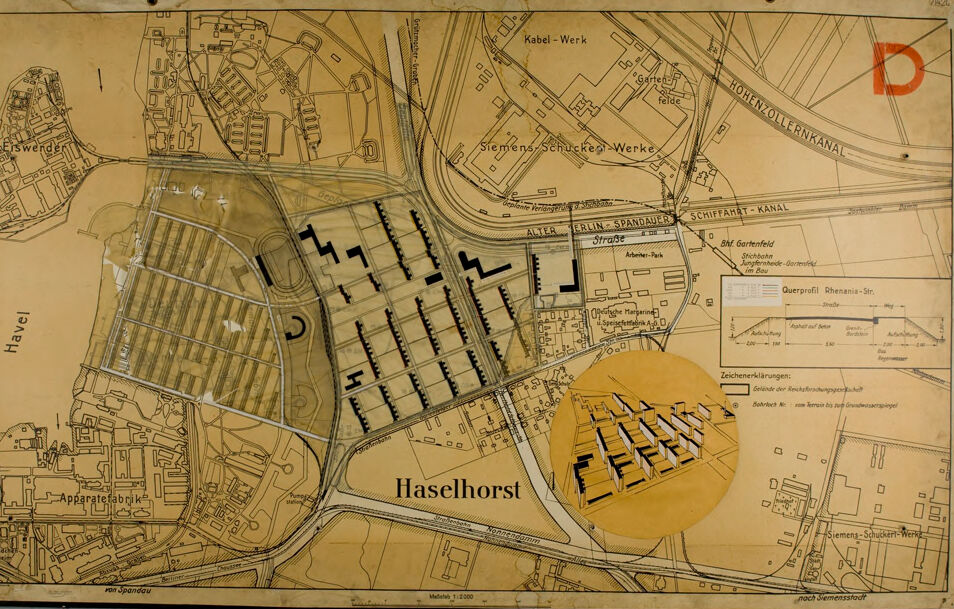
This image shows a historical urban planning map of Haselhorst, a locality in Berlin, Germany. The map is intricately detailed with street layouts, industrial zones, residential areas, and green spaces. Key points and features visible in the map: 1. **Haselhorst**: The main label of the area depicted in the center of the map. 2. **Industrial Zones**: At the top part of the map, names such as “Siemens-Schuckert-Werke” and “Kabel-Werk” denote industrial areas or factories. 3. **Water Bodies**: The map highlights various water channels like “Havel” on the left and “Hohen-Zollern-Kanal” on the right, with “Schiffahrt-Kanal” running horizontally across the map. 4. **Residential Layout**: The central part of the map shows a structured grid plan of residential buildings, illustrated with black shapes possibly representing housing blocks. 5. **Inset Image**: There is an inset illustration in the lower right corner providing a three-dimensional view of what seems to be an architectural model or planned building layout. 6. **Transportation**: Marked roads such as “Berliner-Spandauer Straße” cut across the map, indicating the primary transportation routes. Railway lines and tramways are also marked. 7. **Green Spaces**: Areas marked for parks or gardens, such as “Haselhorst-Park” and “Gartenfeld”, are indicated, showcasing urban planning that incorporates green spaces. 8. **Annotations and Keys**: There are several explanatory notes and keys that likely describe various aspects of the planning, such as building heights, zones, and usage plans. The map presents a comprehensive depiction of urban planning during the period, displaying both residential and industrial planning along with transportation and green spaces.
Created by gpt-4 on 2025-02-05
What you're seeing is a vintage industrial site plan. It depicts an aerial layout of a manufacturing, residential, or business development area. Key elements illustrated in the plan include: - Labeled streets, canals, and possibly railway tracks. - Delineated blocks and buildings, which may suggest industrial facilities or other structures, indicated with black-filled rectangles and various outlined shapes. - A river named "Havel" running through the upper-left section of the plan. - An area labeled "Haselhorst" toward the center bottom. - A zoomed-in inset showing a detail of the layout with 3D block representations to give a perspective view of the structures within that particular section. - On the right side, there's a canal labeled "HOHENZOLLERNKANAL" and another called "SCHIFFAHRT - KANAL" intersecting it. - The print features a legend or key, labeled "Zeichenerklärungen," explaining the symbols used within the map, such as "Bau-Grenzlinie" (building line) and "Schienen" (rails). - The color scheme is primarily sepia-tone, suggesting age, with the map lines and text in black for contrast. - There may be a bit of wear and tear visible on the plan, indicating physical aging of the material. - The document's aspect and styling suggest it is of European origin, possibly German due to the language used in text annotations. Given the industrial nature of the site plan, it was likely used for urban planning, administration, or to provide an overview for individuals working in or with the facilities depicted. The map's details and the organization suggest a well-planned infrastructure catering to both industrial and residential needs.
Anthropic Claude
Created by claude-3-5-sonnet-20241022 on 2025-02-05
This appears to be a historical map or site plan of an area called Haselhorst, which shows various industrial and urban developments. The map includes several notable features: 1. Industrial facilities, including what appears to be "Siemens-Schuckert-Werke" and "Kabel-Werk" (cable works) 2. A canal system, with what looks like "Berlin-Spandauer Schiffahrt-Kanal" marked 3. Various building layouts shown in black geometric shapes 4. A circular or semicircular highlighted area in yellow/orange 5. Street layouts and infrastructure 6. What appears to be an "Apparatefabrik" (apparatus factory) The map has a yellowed, aged appearance suggesting it's a historical document, possibly from the early-to-mid 20th century. The level of detail and precision in the drawing suggests this was likely an official planning or engineering document, possibly used for urban development or industrial planning purposes.
Created by claude-3-opus-20240229 on 2025-02-05
The image appears to be an old map or urban plan of a city or town called Haselhorst. The map shows various buildings, streets, waterways and other infrastructure in a hand-drawn style typical of older city plans and blueprints. The layout depicts densely packed structures, likely a mix of residential, commercial and industrial buildings. Railways or tram lines seem to cut through parts of the town. A key or legend in the bottom right provides symbols referencing different elements on the map. The overall aesthetic has a vintage feel, with aged paper and an earthy color palette of primarily browns and tans. Handwritten labels and annotations are visible, identifying specific locations and providing additional details about the mapped area and planned developments.
Created by claude-3-haiku-20240307 on 2025-02-05
This image appears to be a detailed map of the town of Haselhorst. The map shows the layout of streets, buildings, and other infrastructure within the town. It includes labels for various sites and facilities, such as "Kabel-Werk" (Cable Works), "Schiffart-Kanal" (Shipping Canal), and "Gartenfelde" (Garden Fields). The map seems to have been created for urban planning or administrative purposes, providing a comprehensive view of the geographical features and layout of Haselhorst.
Meta Llama
Created by us.meta.llama3-2-11b-instruct-v1:0 on 2025-03-16
The image is a map of the city of Haselhorst, Germany, with a focus on the industrial area. The map is drawn in black and white on a yellowed paper, with the title "Haselhorst" written in large letters at the bottom center. * **Map Features:** * The map shows the city's layout, including roads, buildings, and other features. * There are several labels and annotations throughout the map, including the names of streets, buildings, and landmarks. * The map also includes a key or legend that explains the symbols and colors used on the map. * **Industrial Area:** * The industrial area is located in the center of the map, and it appears to be a large complex of factories and warehouses. * The area is surrounded by roads and railways, and there are several buildings and structures within the complex. * The map also shows the location of several other industrial areas and facilities in the surrounding region. * **Other Features:** * The map also shows the location of several other features, including parks, schools, and churches. * There are also several labels and annotations that provide additional information about the city and its history. * The map appears to be a historical document, possibly from the early 20th century. Overall, the map provides a detailed view of the city of Haselhorst and its industrial area, as well as other features and landmarks. It is a useful resource for anyone interested in the history and geography of the region.
Created by us.meta.llama3-2-90b-instruct-v1:0 on 2025-03-16
The image depicts a map of a city or town, with various buildings and roads marked. The map is yellowed and appears to be old, with some areas faded or torn. It features a mix of black and white lines, symbols, and text, which are likely used to represent different types of infrastructure, such as roads, buildings, and utilities. In the center of the map, there is a large, circular inset that shows a detailed view of a specific area. This inset is also yellowed and features a similar mix of black and white lines and symbols. The background of the map is a light brown color, which suggests that it may have been printed on paper or another type of material. Overall, the image appears to be a historical map of a city or town, possibly from the early 20th century. It provides a detailed view of the area's infrastructure and layout, which could be useful for researchers, historians, or urban planners.
Amazon Nova
Created by amazon.nova-pro-v1:0 on 2025-02-05
The image is a map of a city, and it is printed on a piece of paper. The map is divided into four sections, and each section has a different color. The map also has a yellow circle in the middle, and it has the word "Haselhorst" written on it. There are also other words written on the map, such as "Hafel" and "Apparatefabrik." The map also has a red letter "D" on the top right corner.
Created by amazon.nova-lite-v1:0 on 2025-02-05
The image shows a map of a town with a focus on the area around the Siemens-Schuckert-Werke factory. The map is printed on a yellow background and has a circular yellow outline with a drawing of a building inside it. The map includes street names, landmarks, and a legend with symbols and explanations. The map also includes a watermark with the text "Haselhorst" in the center.
Text analysis
Amazon