Machine Generated Data
Tags
Color Analysis
Feature analysis
Amazon
Clarifai
AWS Rekognition
| Passport | 88.3% | |

Captions
Microsoft
created by unknown on 2018-04-19
| a close up of text on a white background | 83.8% | |
| a close up of text on a white surface | 82.8% | |
| a close up of text on a black background | 80% | |
Clarifai
No captions written
Salesforce
Created by general-english-image-caption-blip on 2025-05-11
a photograph of a map of a map of a map of a map of a map of a
Created by general-english-image-caption-blip-2 on 2025-06-28
a map of the japanese empire, with asian characters
OpenAI GPT
Created by gpt-4o-2024-11-20 on 2025-06-09
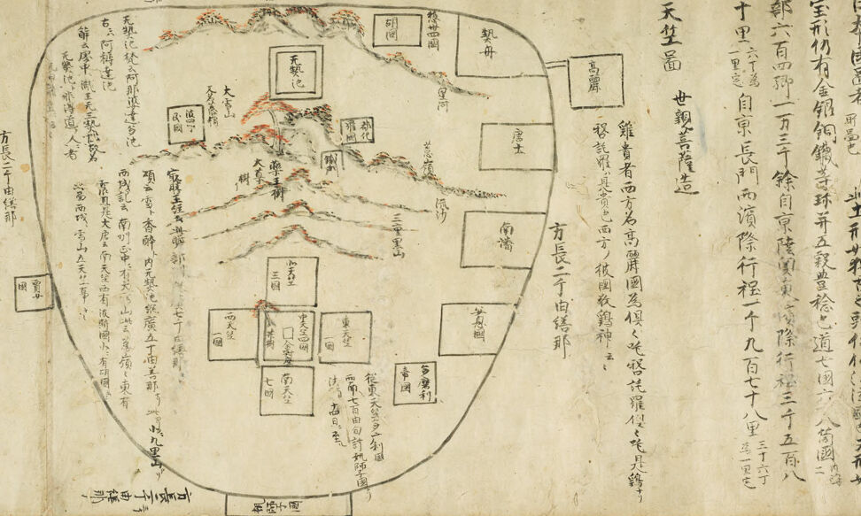
This image depicts a historical map or diagram, most likely originating from Japan. It appears hand-drawn, with text written in classical Japanese kanji and possibly katakana. The diagram includes geographical or symbolic elements, such as mountains colored with shades of red and black in the upper central region. These mountains branch outward, with annotations indicating their names or significance. Below the mountains, there are rectangular or square areas labeled with text, possibly representing settlements, landmarks, or regions.
The overall shape of the map is ovular or irregular, which might suggest either symbolic abstraction or a specific view of the area being mapped. The layout emphasizes key centers, pathways, and features, indicating that the map may serve a religious, cultural, or pilgrimage-related purpose rather than being a strictly cartographical representation.
On the right side, there is vertical text columned in a way that suggests instructions, explanations, or stories connected to the map. The text seems to describe the terrain, locations, and their significance. The style reflects traditional Japanese cartography and illustrates the intersection of artistic and functional mapping techniques in historical Japan.
Created by gpt-4o-2024-08-06 on 2025-06-09
The image depicts a historical map known as a "gyogi zu," which is a medieval Japanese map illustrating China, Korea, and Japan. The map is drawn in a simple style with schematic representations of borders and territories. The layout is roughly oval-shaped, showing stylized mountain ranges primarily colored in red and black. Various key locations and regions are labeled using kanji characters throughout the map. Informational text in vertical columns is written on the right side of the map, which provides contextual details or descriptions about the mapped territories, possibly discussing distances, relations, or cultural aspects. The overall appearance suggests a focus on relationships and understanding of geographical spaces during the medieval period in Japan rather than accurate cartographic representation by contemporary standards.
Anthropic Claude
Created by us.anthropic.claude-3-5-sonnet-20241022-v2:0 on 2025-06-25
This appears to be a historical Japanese map or diagram with a circular design. The image contains numerous Japanese characters and text boxes arranged in a circular pattern. Along the edges and within the circle are various annotations and text written in traditional Japanese script. The document appears to be quite old, with a yellowed or aged paper background. There are some reddish markings or highlights visible in certain areas, particularly along what appears to be a mountain range or geographical feature drawn within the circle. The overall layout suggests this might be some kind of administrative, geographical, or organizational chart from traditional Japan, possibly used for planning or documentation purposes.
Created by claude-3-haiku-20240307 on 2024-12-30
This image appears to be an old handwritten map or diagram with various labels and annotations in an Asian language, possibly Chinese or Japanese. The map depicts a mountainous landscape with various locations or landmarks marked. There are no human faces visible in this image.
Created by claude-3-opus-20240229 on 2024-12-30
The image appears to be an old Japanese or Chinese map or diagram drawn on aged paper or parchment. It shows a roughly circular arrangement with many rectangular sections connected by lines, along with Chinese or Japanese characters labeling each part. The layout resembles a conceptual map or a depiction of relationships between various locations, concepts or entities. The aged appearance and calligraphic text suggest this is an antique document, likely of historical and cultural significance, though without more context the exact meaning is unclear to me.
Created by claude-3-5-sonnet-20241022 on 2024-12-30
This appears to be a historical Japanese map or diagram, drawn in a circular format with various boxes containing Japanese characters arranged within the circle. The image has a weathered, aged appearance on what seems to be parchment or old paper. There are mountain-like features drawn with subtle red and black ink, and numerous text annotations both inside and outside the main circular boundary. The text is written in traditional Japanese characters (kanji), and appears to be arranged in a specific organizational or hierarchical pattern. Around the edges of the circular diagram, there are additional notes or explanations written in vertical columns, which is traditional for Japanese text. This looks like it could be an administrative, geographic, or genealogical document from Japan's historical period.
Meta Llama
Created by us.meta.llama3-2-11b-instruct-v1:0 on 2025-06-09
The image presents a detailed, hand-drawn map on aged paper, showcasing a mountainous region with several peaks and valleys. The map is rendered in black ink, with some areas highlighted in red and orange.
Key Features:
- Mountainous Region: The map depicts a mountainous area with multiple peaks and valleys, suggesting a topographical representation of a specific region.
- Hand-Drawn Illustration: The map is drawn by hand, indicating a personal or artisanal creation rather than a mass-produced product.
- Aged Paper: The paper has an aged appearance, with visible signs of wear and tear, such as yellowing, creases, and stains.
- Black Ink and Red/Orange Highlights: The map is primarily drawn in black ink, with some areas highlighted in red and orange, possibly to indicate specific features or landmarks.
- Chinese Characters: The map features Chinese characters, which may provide additional information about the region, such as place names, geographical features, or cultural significance.
- Scale and Orientation: The map does not include a scale or orientation markers, making it difficult to determine the exact location or size of the depicted region.
- Artistic Style: The map's artistic style suggests a focus on aesthetic appeal, with intricate details and decorative elements, rather than purely functional or practical considerations.
Possible Context:
- Historical Document: The map may be a historical document, created during a specific time period or for a particular purpose, such as navigation, exploration, or cultural documentation.
- Artistic Expression: The map could be an artistic expression, created to showcase the beauty and uniqueness of the depicted region, rather than for practical or functional purposes.
- Cultural Significance: The map may hold cultural significance, representing a particular region, community, or tradition, and serving as a symbol of identity or heritage.
Conclusion:
The image presents a unique and intriguing map that combines artistic expression with geographical representation. While the exact context and purpose of the map are unclear, it is evident that it holds cultural and historical significance, and its aged appearance and hand-drawn style suggest a personal or artisanal creation.
Created by us.meta.llama3-2-90b-instruct-v1:0 on 2025-06-09
The image is a map of an area, possibly a region or a city, with various symbols and markings. The map appears to be hand-drawn and is written in Chinese characters.
Key Features:
- Map Outline: The map is outlined in black ink, with a rough shape resembling a shield or a teardrop.
- Symbols and Markings: There are several symbols and markings on the map, including:
- Red and Black Lines: These lines appear to represent roads, rivers, or other geographical features.
- Squares and Rectangles: These shapes may represent buildings, landmarks, or other points of interest.
- Chinese Characters: The map is covered in Chinese characters, which likely provide information about the locations and features depicted on the map.
- Background: The background of the map is a light brown color, which may indicate that it is an old or aged document.
Overall Impression:
The image suggests that this map is an important historical document, possibly created for navigation or planning purposes. The use of Chinese characters and the style of the map suggest that it may be from the Qing dynasty or earlier.
Amazon Nova
Created by amazon.nova-lite-v1:0 on 2025-06-08
The image depicts an antique Japanese manuscript, likely from the Edo period (1603–1868). The manuscript is written in classical Japanese script, known as kanji and kana, and appears to be a detailed map or plan of a landscape. The map is divided into sections, each marked with various annotations and labels in kanji. The central part of the map shows a mountainous terrain with various features, such as peaks, valleys, and rivers, illustrated with a combination of line drawings and text.
The right side of the manuscript contains additional text, possibly descriptions or explanations of the map's features. The text is written in a vertical format, typical of traditional Japanese manuscripts. The paper is aged and shows signs of wear, including discoloration and slight tears. The map is drawn with a fine brush, and the annotations are meticulously handwritten, indicating the high level of craftsmanship and attention to detail typical of Japanese cartography during the Edo period.
Created by amazon.nova-pro-v1:0 on 2025-06-08
The image depicts a map that appears to be hand-drawn on paper. The map is enclosed within a frame that resembles a rectangle. The map is divided into several sections, each of which contains text written in a foreign language. The map also includes a few red marks and lines. The text is written in a vertical direction, and some of the text is written in a horizontal direction.
Google Gemini
Created by gemini-2.0-flash on 2025-05-15
Here's a description of the image:
The image shows an old, hand-drawn map and accompanying text on a piece of parchment-like paper. The map itself is roughly oval-shaped with illustrations of mountainous regions and rectangular markers, likely representing towns or locations, scattered within its borders. The mountains are drawn in a simple, stylized manner, with small trees depicted on their slopes. The rectangular markers are labeled with text.
The parchment is filled with vertical columns of handwritten text in what appears to be an East Asian script (likely Japanese or Chinese). The script is dense and intricate, with small, precise characters. The paper has a slightly yellowish tint, suggesting age and possible wear. The layout is typical of traditional East Asian calligraphy, with text arranged vertically and reading from right to left. The map and the text are both drawn in ink, with varying degrees of detail and density.
Created by gemini-2.0-flash-lite on 2025-05-15
Here's a description of the image:
Overall Impression:
The image appears to be a detailed, hand-drawn map, likely from a historical Japanese source. It's rendered on aged, textured paper, suggesting it is quite old. The map depicts a geographical area, with numerous annotations in what seems to be classical Chinese or Japanese characters.
Key Features:
- Cartographic Style: The map uses a stylized, pictorial representation. Mountains are depicted with stylized, jagged lines. Rectangular boxes are scattered throughout, likely representing towns, villages, or administrative divisions.
- Text and Annotations: The map is covered in text. The annotations appear to provide place names, geographical features, and likely some historical or political context.
- Shape and Outline: A roughly circular or oval outline frames the main area of the map.
- Colors: The map primarily employs black ink for the drawings and text. Some red or orange accents are used, especially for the trees and possibly to highlight certain geographical features.
Interpretation:
The map likely represents a region, possibly in Japan or a neighboring area influenced by Japanese culture. The detailed annotations suggest the map was made with great care and accuracy. Without a deeper understanding of the language, it is difficult to ascertain specific details. However, it is clearly a valuable historical document.
Mistral Pixtral
Created by us.mistral.pixtral-large-2502-v1:0 on 2025-05-30
The image depicts an old, hand-drawn map with accompanying text, likely of East Asian origin, given the use of Chinese characters. The map appears to be an early representation of a region, possibly Japan or another part of East Asia.
Key features of the map:
- Geographical Layout: The map shows various landforms, including mountains, rivers, and possibly coastal areas. The mountains are depicted with wavy lines, and rivers are shown as meandering lines.
- Place Names: Several locations are marked with rectangular boxes containing Chinese characters, indicating the names of provinces, cities, or significant landmarks.
- Directional Orientation: The map is oriented with the top likely representing north, although traditional East Asian maps sometimes oriented east at the top.
- Text Annotations: There is text written vertically on the right side of the map. This text likely provides additional information about the regions depicted, such as descriptions of the land, historical notes, or administrative details.
The overall style and content suggest that this map is a historical artifact, possibly from the pre-modern era, used for administrative, military, or scholarly purposes. The detailed annotations and precise labeling indicate a high level of cartographic skill for the time period it was created.
Qwen
Created by Qwen/Qwen2.5-VL-7B-Instruct on 2025-07-24
The image appears to be an ancient map or diagram, possibly from East Asian culture, given the style of writing and the traditional symbols. Here's a breakdown of the elements visible in the image:
Map/Chart Design: The central circular design resembles a map, possibly of a geographical or legendary region, with labeled sections and a border around it.
Geographical Features: The circular map includes various labeled sections that might represent different territories or landforms. These sections are connected with lines and include symbols and text that seem to denote specific places or regions.
Textual Content: Extensive text is present both within the circular diagram and to the right of it. The text is written in an East Asian script, likely Chinese or Japanese, and includes numerical data, possibly indicating distances or geographical features.
Decorative Elements: The map is adorned with decorative elements, such as lines and small symbols, which may represent roads, mountains, or other geographical features.
Color and Style: The map uses a limited color palette, with red and black being predominant. The style suggests it could be from a historical or religious text, possibly with purposes related to navigation, cosmology, or cultural lore.
Historical Context: The style and content might suggest this map is from a historical or cultural text, possibly related to East Asian geography, mythology, or religious texts.
Given the script and style, this document could be a historical map, a religious diagram, or a geographical chart, likely developed for purposes of navigation, religious significance, or cultural documentation.
Created by Qwen/Qwen2.5-VL-72B-Instruct on 2025-07-24
This image is an ancient map of Japan, likely from the Edo period (1603-1868). It is drawn in a traditional style and features handwritten Japanese text. The map is oval-shaped and illustrates the geography of Japan with various regions and landmarks labeled in black ink. Red lines are used to depict mountain ranges and other topographical features. The text in the margins provides additional information about the map, including historical context and geographical details. The overall style is indicative of hand-drawn maps from that era, with a focus on depicting the landmass and its features rather than precise measurements.
Text analysis
Amazon