Machine Generated Data
Tags
Color Analysis
Face analysis
Amazon

AWS Rekognition
| Age | 28-38 |
| Gender | Male, 50.8% |
| Happy | 76.2% |
| Fear | 11.5% |
| Surprised | 8.5% |
| Sad | 3.3% |
| Confused | 1.9% |
| Disgusted | 1.9% |
| Calm | 1.2% |
| Angry | 1.1% |
Feature analysis
Amazon
| Poster | 94% | |
Categories
Imagga
| streetview architecture | 99.7% | |
Captions
Microsoft
created on 2022-06-10
| engineering drawing | 78% | |
OpenAI GPT
Created by gpt-4 on 2025-02-18
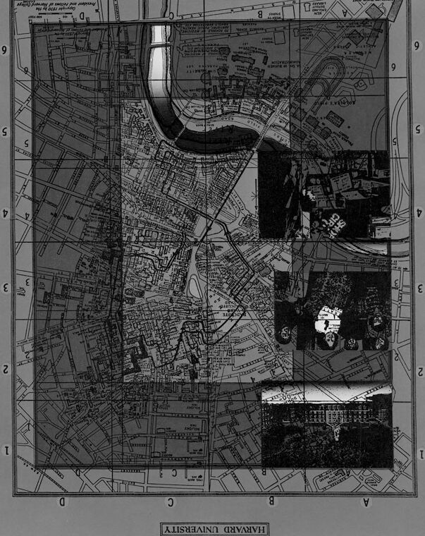
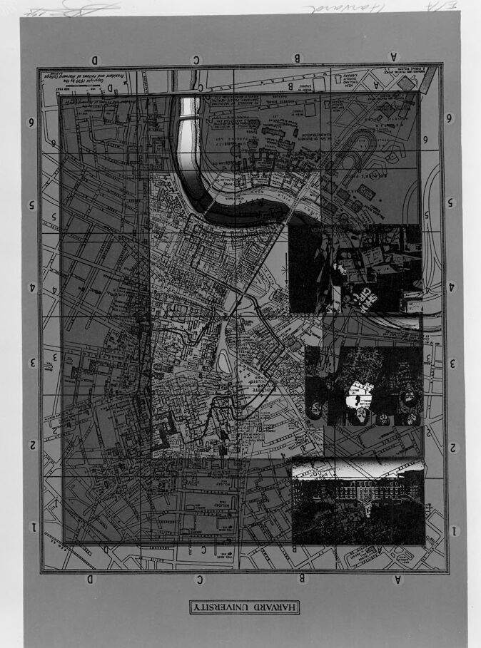
This image shows a black and white map that is oriented vertically. Given the reversed text at the bottom, reading "HARVARD UNIVERSITY," the image appears to be a map of Harvard University and its surrounding areas, albeit the entire image is mirrored. The map includes lots of details like streets, buildings, and possibly other landmarks, which are common in urban cartography. The style and level of detail suggest that this map is likely designed for practical use, such as navigating the campus and its immediate vicinity. There is a grid superimposed over the map with numbers running from 0 to 9 along the top and bottom edges and letters from A to J along the right edge, suggesting that it may be used for referencing specific sections of the map. The left side has punched holes, typically used for binding or filing the map in a larger collection. The reversed text and mirrored image indicate that the photo is either of the backside of a transparent or semi-transparent map or that the photo itself is flipped during the process of capturing or printing. The map is framed by a light background with annotations or markings around the edges, most notably in the upper right corner with a handwritten note that seems to be an inventory or reference number.
Created by gpt-4o-2024-05-13 on 2025-02-18
The image appears to be an upside-down map with elements of a collage. The map is detailed and includes various geographical and street information, likely of an urban area. Towards the edges of the map, there are grid markers with letters and numbers that serve as coordinates for locating positions within the map. Moreover, integrated within the map, there are several black and white photographic images of buildings and possibly landmarks. These images have been placed in specific locations on the map, possibly to represent the actual locations of these buildings or landmarks within the mapped area. At the bottom of the image, which is upside down, there is a label that reads "HARVARD UNIVERSITY." This indicates that the map might be related to the Harvard University campus or surrounding area. The visual presentation suggests a combination of cartographic information along with photographic documentation, offering a richer contextual understanding of the place.
Anthropic Claude
Created by claude-3-haiku-20240307 on 2025-02-18
This image appears to be a detailed map or diagram of an urban area, with grids and geographic features indicated. The map includes several inset images that seem to depict different parts of the same city or region. The overall layout and design of the map suggests this is likely an official or technical document rather than a general reference map. There are no human faces or identifiable individuals visible in the image.
Created by claude-3-opus-20240229 on 2025-02-18
The image appears to be an old black and white map or diagram of a city, possibly titled "Harvard University". The map shows a detailed grid layout of city blocks and streets. Some areas are shaded darker than others, potentially indicating buildings or structures. The map includes numbered grid lines along the edges for reference. Handwritten text at the bottom labels it as "Harvard University".
Created by claude-3-5-sonnet-20241022 on 2025-02-18
This appears to be a historical map labeled "HARVARD UNIVERSITY." It's a black and white street map showing the layout of the Harvard campus area and surrounding streets in Cambridge, Massachusetts. The map features a distinctive curve of the Charles River at the top, and shows a detailed grid of streets, buildings, and campus facilities. There are three photographic insets on the right side of the map showing what appear to be campus buildings or scenes. The map has a coordinate system around its borders marked with numbers and letters. The street layout is quite detailed, showing the complex network of roads and pathways throughout the university area. The overall presentation is in a formal cartographic style typical of institutional maps from an earlier era.
Meta Llama
Created by us.meta.llama3-2-11b-instruct-v1:0 on 2025-03-13
The image is a black and white map of Harvard University, with a large "U" shape in the center. The map is surrounded by a grid of numbers and letters, and there are several buildings and roads visible on the map. * The map is oriented with north at the top, and the "U" shape appears to be a body of water or a park. * There are several buildings and roads visible on the map, including what appears to be a large building or complex in the center of the "U" shape. * The map also includes several other features, such as trees and other vegetation, which are likely part of the university's campus. * The overall impression is that the map is a detailed and accurate representation of the Harvard University campus, with a focus on the layout of the buildings and roads. Overall, the image provides a clear and informative view of the Harvard University campus, highlighting its unique layout and features.
Created by us.meta.llama3-2-90b-instruct-v1:0 on 2025-03-13
The image depicts a map of Harvard University, with a gray background and black lines indicating the layout of the campus. The map is oriented with north at the top, and it appears to be a historical or vintage map, possibly from the early 20th century. The map shows various buildings, roads, and other features on the campus, including the Charles River, which runs along the eastern edge of the map. There are also several labels and annotations on the map, including the names of buildings, streets, and other landmarks. In the center of the map, there is a large, dark gray rectangle that appears to be a building or a group of buildings. This rectangle is surrounded by several smaller rectangles and squares, which may represent individual buildings or rooms within the larger structure. Overall, the map provides a detailed and informative view of the Harvard University campus, showing its layout and features in a clear and concise manner. It is likely that this map was used for educational or administrative purposes, such as planning and navigation.
Amazon Nova
Created by amazon.nova-lite-v1:0 on 2025-02-18
This image is a map of the city of Rome, Italy, showing the layout of the streets and buildings in the area. The map is divided into several sections, each labeled with a letter and a number, indicating the specific location within the city. The map also includes a legend in the bottom right corner, which provides information about the different symbols and colors used on the map to represent various features such as roads, buildings, and landmarks. The map appears to be a detailed and accurate representation of the city, with a high level of detail and clarity.
Created by amazon.nova-pro-v1:0 on 2025-02-18
The image shows a map of a city with a grid-like structure, divided into sections with numbers and letters. The map appears to be a detailed plan or layout of the city, possibly for urban planning or architectural purposes. The sections are labeled with numbers and letters, and there are various symbols and markings on the map, indicating different features or areas of interest. The overall appearance of the map suggests a level of organization and planning, with a clear structure and layout.
Text analysis
Amazon