
Machine Generated Data
Tags
Color Analysis
Feature analysis
Amazon
Clarifai
AWS Rekognition
| Painting | 97.7% | |


Categories
Imagga
created on 2019-11-04
| food drinks | 62.4% | |
| beaches seaside | 14.5% | |
| nature landscape | 14.1% | |
| streetview architecture | 4% | |
| paintings art | 2.6% | |
Captions
Clarifai
Created by general-english-image-caption-clip on 2025-07-14
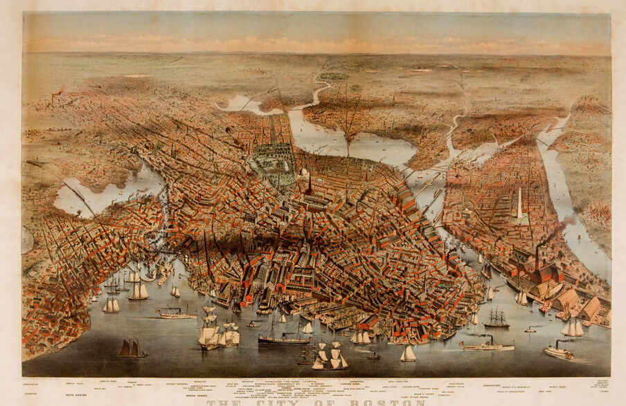
a map of the city.
Salesforce
Created by general-english-image-caption-blip on 2025-05-15
a photograph of a map of the city of boston, usa
OpenAI GPT
Created by gpt-4o-2024-05-13 on 2025-02-01
The image is an illustrated birds-eye view map of the City of Boston, produced around 1877. The map details the layout of the city with an emphasis on Boston's waterways, harbors, and the density of its buildings. Key features include a depiction of numerous sailing ships and boats positioned in the harbor area, illustrating Boston's active maritime activity during the time. Surrounding water bodies, residential structures, and other infrastructures are also visible. The typography beneath the image identifies the map as "The City of Boston" along with a list of certain notable landmarks or areas labeled for reference. The color palette of the illustration is muted with shades of brown, red, and blue, giving it a vintage aesthetic typical of 19th-century maps.
Created by gpt-4 on 2025-02-01
This image is a vintage map or bird's-eye view illustration of the city of Boston. The perspective is from above, giving a detailed, panoramic view of the city and its architecture, with an emphasis on individual buildings and the street layout. The waterfront is bustling with what looks like maritime activity, including several ships and boats in the harbor area. The map is colored, presumably by hand, with hues that differentiate buildings, land, and water. The title "THE CITY OF BOSTON." is prominently displayed on the lower portion of the image, centered between various pieces of text that likely provide additional context and details about the map. The edges of the paper appear to be slightly worn or aged, implying that it is an antique or a reproduction of an original vintage map.
Anthropic Claude
Created by us.anthropic.claude-3-5-sonnet-20241022-v2:0 on 2025-06-29
This is a historical bird's-eye view map of Boston from what appears to be the mid-to-late 19th century. The map shows the city from an elevated perspective, with incredible detail of the urban landscape, including the distinctive peninsula shape of Boston proper surrounded by water. The buildings are rendered in a reddish-brown color, and you can see the dense street grid of the city center.
The harbor is prominently featured with numerous sailing vessels and steam ships dotting the water, illustrating Boston's importance as a major seaport during this period. The map shows various inlets and waterways, including what would be the Charles River and Boston Harbor.
The level of detail is remarkable, showing individual buildings, church spires, and the city's irregular street pattern that followed the original colonial-era layout rather than a strict grid system. The image has a warm, sepia-toned quality typical of period lithographs, with a pale blue sky at the horizon.
At the bottom of the image is the title "THE CITY OF BOSTON" along with what appears to be a key or legend listing various locations in the city. This type of bird's-eye view map was popular in the 19th century and would have been used both for practical purposes and as a decorative piece showing civic pride in the growing metropolis.
Created by claude-3-5-sonnet-20241022 on 2025-02-01
This is a historic bird's-eye view map of Boston, Massachusetts, likely from the late 19th century. The image shows an aerial perspective of the city, with its distinctive peninsula shape surrounded by water. The map is rendered in warm, sepia-like tones with reddish-brown buildings and detailed street patterns. The harbor is prominently featured, showing numerous sailing vessels and ships of various sizes dotting the water. The city's dense urban layout is clearly visible, with its characteristic irregular street pattern reflecting Boston's organic growth from its colonial origins. Notable features include the winding coastline, various wharves extending into the harbor, and what appears to be the Charles River wrapping around portions of the city. The level of detail is remarkable, showing individual buildings, church spires, and other architectural features of the period. The title "THE CITY OF BOSTON" appears at the bottom of the image.
Created by claude-3-opus-20240229 on 2025-02-01
The image depicts an old, panoramic map or illustration of the city of Boston. It shows a bird's eye view of the city's layout, with densely packed buildings, streets, and waterways filled with various types of ships and boats. The buildings are rendered in great detail, showing their architectural styles and giving a sense of the city's scale and urban density in that era. The map's sepia tones and antique appearance suggest it is a historical document from the 19th century, providing a fascinating glimpse into Boston's past cityscape and port activity.
Created by claude-3-haiku-20240307 on 2025-02-01
This image appears to be a panoramic view of the city of Boston in the late 19th century. It shows a detailed illustration of the city's skyline, with numerous buildings, spires, and landmarks visible. The harbor is filled with ships and boats, indicating the importance of maritime activity to the city at the time. The overall perspective suggests an aerial or bird's-eye view of Boston, allowing the viewer to appreciate the scale and density of the urban landscape.
Meta Llama
Created by us.meta.llama3-2-11b-instruct-v1:0 on 2025-03-12
The image is a vintage map of Boston, Massachusetts, titled "THE CITY OF BOSTON" in the center at the bottom. The map is rendered in sepia tones and features a mix of hand-drawn and printed elements.
Map Features:
- The map showcases the city's layout, including streets, buildings, and waterways.
- It highlights notable landmarks such as the State House, Faneuil Hall, and the harbor.
- The map also depicts the city's early transportation infrastructure, including roads, bridges, and wharves.
Visual Elements:
- The map includes several illustrations of ships and boats in the harbor, which were likely added to enhance the visual appeal of the map.
- The title of the map, "THE CITY OF BOSTON," is prominently displayed at the bottom of the image.
- The map's border is a light brown color, which adds a touch of elegance to the overall design.
Historical Context:
- The map appears to be from the 19th century, based on the style of the illustrations and the level of detail included.
- It is likely that the map was created by a local cartographer or publisher who wanted to showcase the city's growth and development during this period.
- The map may have been used as a tool for navigation, planning, or simply as a decorative piece for homes and offices.
Overall:
- The map provides a fascinating glimpse into Boston's past, highlighting its early architecture, transportation systems, and cultural landmarks.
- It is a valuable resource for historians, researchers, and anyone interested in learning more about the city's history and development.
Created by us.meta.llama3-2-90b-instruct-v1:0 on 2025-03-12
This image depicts an old map of Boston, Massachusetts, with the title "THE CITY OF BOSTON" at the bottom. The map is presented in a sepia tone and features a prominent illustration of the city's layout, including its streets, buildings, and waterways.
The map showcases the city's harbor, with numerous ships and boats visible in the water. The surrounding landscape is also depicted, providing a comprehensive view of Boston's geography. The overall design of the map suggests that it was created during the late 19th or early 20th century, given its vintage aesthetic and style.
The map appears to be a historical document, likely used for educational or informational purposes. It provides a unique glimpse into Boston's past, offering insights into the city's development and growth over time.
Amazon Nova
Created by amazon.nova-pro-v1:0 on 2025-02-01
The image is an antique map of the city of Boston, Massachusetts, USA. The map is printed on paper and has a yellowish hue, giving it an old-fashioned look. The map shows the city's layout, including the streets, buildings, and waterways. The map also includes the names of various landmarks and neighborhoods within the city. The map is surrounded by a border that includes the words "The City of Boston" at the top.
Created by amazon.nova-lite-v1:0 on 2025-02-01
The image is a vintage map of Boston, Massachusetts. The map is detailed and shows the city's layout, including its streets, buildings, and landmarks. The map is divided into sections, with each section labeled with the name of a different area of the city. The map also includes a key that identifies the different types of buildings and landmarks depicted on the map. The map is framed in a white border, and the overall color scheme is muted and vintage-inspired.
Google Gemini
Created by gemini-2.0-flash on 2025-05-20
The image is a historical aerial view of the city of Boston. It seems to be a printed map or illustration, likely dating from the late 19th century, judging by the style and the depiction of the city.
The layout presents Boston as a dense urban environment with a well-defined grid pattern of streets and blocks of buildings. Red rooftops dominate the urban fabric, indicating the construction materials of the time. The map also includes bodies of water, such as rivers and bays, outlining the shape of the city's peninsulas and waterfronts.
The skyline features prominent landmarks, including church spires and perhaps other significant structures. In the foreground, ships and sailboats populate the water, providing a sense of maritime activity and the city's connection to the sea.
The style of the illustration is meticulous and detailed, characteristic of cartographic art from that era. A title, "The City of Boston," is prominently displayed along the bottom.
Created by gemini-2.0-flash-lite on 2025-05-20
Here is a description of the image:
This is a detailed and colorful historical map of Boston, Massachusetts, viewed from a bird's eye perspective. The city is rendered with numerous buildings, streets, and waterways in intricate detail. The map covers a significant portion of the Boston area, including the city center, harbor, and surrounding areas. The architecture is portrayed in a way that gives a sense of the three-dimensional nature of the city.
The map depicts the city with a high level of detail. The buildings are rendered in shades of red, brown, and tan, while the streets and other infrastructure are carefully mapped. The waters of the harbor and rivers are a blue-gray, and the land around the city is in a faded green and brown. The map is framed by a light-colored border and includes text identifying the title, "The City of Boston." Additional text and labels are likely present at the bottom of the map, providing further context.
The image evokes a sense of historical documentation, a snapshot of Boston at a particular time.
Mistral Pixtral
Created by us.mistral.pixtral-large-2502-v1:0 on 2025-05-26
The image is a detailed, vintage bird's-eye view map of the City of Boston, likely from the 19th century. This type of map is known for its intricate, perspective illustration that gives a three-dimensional feel to the layout of the city.
Key features of the map include:
Geographical Layout: The map shows the city's layout with various neighborhoods, streets, and landmarks. The Charles River and Boston Harbor are prominently featured, with numerous ships and boats depicted on the water.
Architectural Details: Buildings are illustrated with considerable detail, showing the density and architecture of the city during that period. Notable structures and landmarks are labeled, providing a historical snapshot of Boston's urban landscape.
Transportation and Infrastructure: The map highlights key transportation routes, including roads and railways. Bridges crossing the Charles River are also depicted, showing important connections within the city.
Surrounding Areas: The map extends beyond the immediate city center, showing surrounding towns and areas, which provides context for Boston's regional setting.
Artistic Style: The map is rendered in a style typical of 19th-century cartography, with a focus on aesthetic appeal and detailed illustration. The color palette includes earthy tones, with buildings often depicted in shades of red and brown, and water bodies in blue.
Labels and Annotations: Various parts of the city and significant locations are labeled, helping viewers identify key points of interest. The title "The City of Boston" is prominently displayed at the bottom center of the map.
Overall, this map serves as both a historical document and a piece of art, offering a comprehensive view of Boston during a specific period in history.
Qwen
No captions written
Text analysis
Amazon


