Machine Generated Data
Tags
Color Analysis
Categories
Imagga
| paintings art | 99.8% | |
Captions
Microsoft
created on 2019-02-18
| a close up of text on a white background | 74% | |
| a close up of text on a black background | 71% | |
| a close up of text on a white surface | 70.9% | |
OpenAI GPT
Created by gpt-4o-2024-05-13 on 2025-02-12
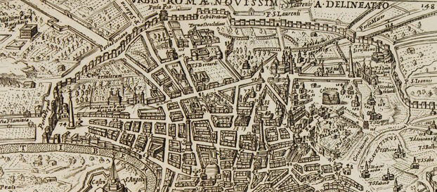
The image depicts an old map or engraving of the city of Rome, showcasing its intricate layout and detailed structures. The map appears to be a historical representation, possibly from the Renaissance or early modern period, given its artistic style and the level of detail in its fortifications, buildings, and street grid. Key features include: - Prominent religious and historical landmarks such as basilicas and large cathedrals. - The Vatican area labeled as "Mons Vaticanus". - The river Tiber snaking through the city, with bridges connecting different parts. - A detailed inclusion of fortifications, city walls, and defensive structures, indicating the strategic and protective measures of the time. - Labels and annotations in Latin, providing names of significant locations and possibly notes regarding the map's creation or points of interest. - A text block at the bottom with numbered annotations that likely correspond to specific sites on the map. The map provides a fascinating glimpse into the historical urban planning and significant structures of Rome, offering valuable insight into the city’s past.
Created by gpt-4 on 2025-02-12
This image is a photograph of an open book displaying a detailed historic map or bird's-eye view engraving of a city, which appears to be an old map of Rome, as indicated by the label "VRBIS ROMA" in the upper part of the map. The map is intricate, with hundreds of individual buildings represented and various streets and landmarks indicated. The map includes annotations and labels, presumably naming streets, buildings, and areas of the city, in a style typical of Renaissance or later maps, suggesting this could be from the 16th to 18th century—although without specific information, it is difficult to determine the exact date or cartographer. Below the map, there is a block of text in a smaller font, possibly providing further details or explanations about the map or the areas depicted. The book's pages are slightly discolored, indicating age, and the edges of the pages are worn, suggesting that the book has been handled and used over time.
Anthropic Claude
Created by claude-3-5-sonnet-20241022 on 2025-02-12
This is a historical map or bird's-eye view of Rome ("Urbis Romae Novissima Delineatio" as stated in the title), likely from the 16th or 17th century. It's an intricate engraving showing the city's layout with remarkable detail, depicting buildings, streets, and major landmarks of Rome. The map is oriented with the Tiber River clearly visible as it winds through the city. The illustration shows the dense urban fabric of Renaissance Rome, with its numerous churches, palaces, and other prominent buildings drawn in a three-dimensional perspective. The city walls are clearly depicted surrounding the urban area, and various important monuments and architectural features can be identified throughout the cityscape. The map includes text at the bottom, presumably providing a key or description of the important sites marked on the map. The overall style is characteristic of Renaissance cartography, combining artistic representation with geographical accuracy. The image appears to be photographed from what looks like an old book or atlas, as evidenced by the visible page edges and aging of the paper.
Created by claude-3-opus-20240229 on 2025-02-12
The image shows an old map or city plan from 1598. It depicts the city of Rome with its many buildings, streets and landmarks drawn in intricate detail from a bird's eye perspective. The map has text captions and a legend providing information about the city. The map is printed in black ink on aged, yellowish paper and appears to be from a very old book, with visible damage and wear around the edges of the page.
Created by claude-3-haiku-20240307 on 2025-02-12
The image appears to be an old map or illustration of a city. The map is highly detailed, showing the layout of a densely populated urban area with numerous buildings, churches, and other structures. The map is labeled "Urbis Romae Nvissima A Deliniatio", indicating it is a depiction of the city of Rome. The map includes various annotations and labeling of different landmarks and features within the city. Overall, this appears to be an intricate and historical illustration of the city of Rome.
Meta Llama
Created by us.meta.llama3-2-11b-instruct-v1:0 on 2025-03-15
The image presents a vintage map of Rome, Italy, titled "URBIS ROMAE NOVISSIMAE DESCRIPTIO A.D. ELINEATO" at the top. The map is rendered in black ink on aged paper, featuring a detailed illustration of the city's layout, including various buildings, streets, and landmarks. **Key Features:** * **Title:** "URBIS ROMAE NOVISSIMAE DESCRIPTIO A.D. ELINEATO" * **Map Illustration:** A detailed illustration of Rome's layout, including buildings, streets, and landmarks * **Paper:** Aged paper with a yellowish hue * **Ink:** Black ink used for the map illustration * **Boundaries:** The map is framed by a rectangular border, with the title at the top * **Text:** Additional text is present at the bottom of the page, although it is not legible **Overall:** The image showcases a historic map of Rome, providing a glimpse into the city's past layout and architecture. The aged paper and black ink give the map a sense of nostalgia and historical significance.
Created by us.meta.llama3-2-90b-instruct-v1:0 on 2025-03-15
The image presents a vintage map of Rome, Italy, with the title "VRBIS ROMA NOVISSIMA DELINEATIO" at the top. The map is rendered in black and white, featuring a detailed illustration of the city's layout, including buildings, streets, and landmarks. A key or legend is situated in the upper right corner, although its contents are illegible due to the image's resolution. At the bottom of the map, a section of text is visible, but it is too small to decipher. The map appears to be an antique print, likely from the 17th or 18th century, given its style and the presence of Latin text. The map is displayed on a worn, yellowed page, suggesting that it is part of an old book or atlas. Overall, the image provides a fascinating glimpse into the historical cartography of Rome, showcasing the city's evolution over time.
Amazon Nova
Created by amazon.nova-pro-v1:0 on 2025-02-12
The image depicts an old book that is open to a page with a map of a city. The map is surrounded by text written in a foreign language. The map is of the city of Rome, with the Vatican in the center. The map is divided into sections, with each section labeled with a letter and a number. The map is surrounded by a border, and the text is written in a cursive font.
Created by amazon.nova-lite-v1:0 on 2025-02-12
The image is of an old book that is open to a page with a black-and-white map. The map is titled "Verbi Romae A. Novissim" and shows the layout of a city, possibly Rome, with various buildings, streets, and landmarks marked. The map is accompanied by text in a foreign language, likely Latin, and appears to be a historical document or map from a previous century. The book's pages are yellowed with age, and the map itself is printed on a separate sheet of paper that is inserted into the book.
Text analysis
Amazon