Machine Generated Data
Tags
Color Analysis
Feature analysis
Amazon

| Building | 95.6% | |


Categories
Imagga
| paintings art | 99.4% | |
Captions
Microsoft
created on 2019-02-18
| a close up of text on a white background | 81.4% | |
| a close up of text on a black background | 77.7% | |
| a close up of text on a white surface | 77.6% | |
OpenAI GPT
Created by gpt-4o-2024-05-13 on 2025-02-12
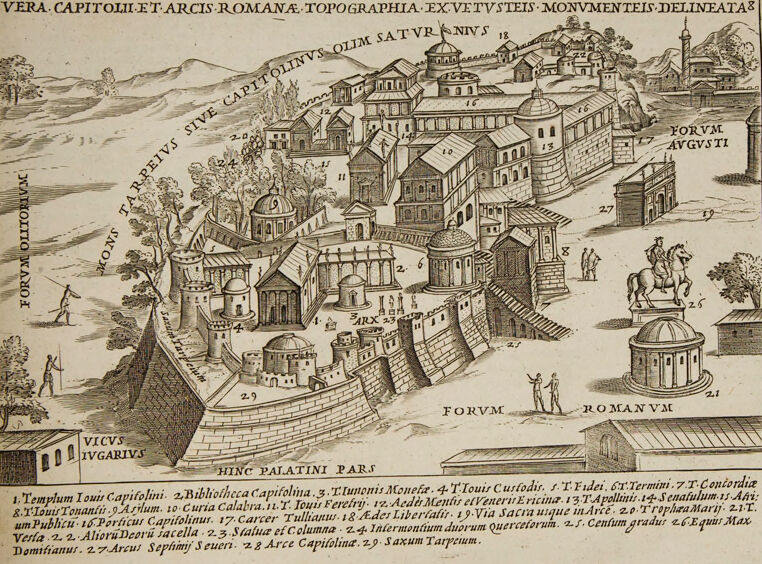
The image is an intricately detailed black and white engraving depicting a topographical map of ancient Rome, focusing on the Capitolium area. The title at the top reads "VERA CAPITOLII ET ARCIS ROMANAE TOPOGRAPHIA EX VETUSTEIS MONUMENTEIS DELINEATA," which translates to "True Topography of the Capitol and Roman Fortress, Drawn from Ancient Monuments." The illustration features various labeled buildings, monuments, and locations within the Capitolium and the surrounding areas. In the center, multiple buildings are labeled with numbers, corresponding to a key at the bottom of the image. Among the labeled structures are temples, libraries, basilicas, and monuments, providing a glimpse into the architectural layout and important landmarks of that time. The depiction includes mountainous backgrounds, streets, and smaller figures, contributing to the map's visual richness and educational value. Key landmarks and areas such as the Forum Romanum (Roman Forum) and the Forum Augusti (Forum of Augustus) are clearly marked. The illustration is detailed, with clear demarcations of walls, gates, and other significant architectural features. The presence of both human and equestrian statues adds to the historical context portrayed in the map. The overall engraving has a classic and antique appearance, indicative of historical cartographic art.
Created by gpt-4 on 2025-02-12
This image is a detailed historical engraving or illustration of a city plan, specifically showing the layout and buildings of ancient Rome's Capitoline Hill and surrounding structures. The top of the image has a title in Latin that translates to "True depiction of the Capitoline and the Roman fortress, as well as their monuments." The illustration is a detailed bird's-eye view, showcasing various Roman buildings, streets, fortifications, and open spaces. Some prominent features include a large open area labeled "FORVM ROMANVM," which is the Roman Forum, and another labeled "FORVM AVGVSTI," likely the Forum of Augustus. There are also other labeled structures such as temples, arches, and statues, which indicate significant historical and cultural landmarks. Below the illustration, there is a numbered key in Latin that corresponds to various labeled points in the drawing. The key provides the names of the monuments and sites depicted above, giving viewers an educational guide to the historical layout. This type of image is typical of old historical books or atlases, which aimed to educate readers about the geography and architecture of significant historical places. The illustration style is meticulous and detailed, suggesting it was created for scholarly or educational purposes.
Anthropic Claude
Created by claude-3-5-sonnet-20241022 on 2025-02-12
This is a historical architectural drawing or engraving showing a topographical view of ancient Rome's Capitoline Hill (Capitolium) and surrounding areas. The title at the top reads "VERA CAPITOLII ET ARCIS ROMANAE TOPOGRAPHIA EX VETVSTIS MONVMENTIS DELINEATA" which indicates this is a true topographical representation of the Roman Capitol and fortress based on ancient monuments. The drawing shows various important Roman structures in an elevated perspective view, with buildings, temples, and fortifications arranged on the hillside. Notable features include the Forum Romanum at the bottom, Forum Augusti to the right, and various temples and civic buildings on the Capitoline Hill itself. There's a detailed legend at the bottom of the image that numbers and identifies different structures. The style is typical of Renaissance or early modern architectural illustrations, with careful attention to architectural details, perspective, and layout. Small figures are included to give scale, and there are trees and landscape elements shown as well. The drawing includes a horse-mounted statue or monument in the lower right portion. The image appears to be from a historical book or academic work meant to document and study the architecture and layout of ancient Rome. It's rendered in a line drawing style with cross-hatching for shading and depth.
Created by claude-3-opus-20240229 on 2025-02-12
This image depicts an engraved illustration of the Roman Forum, or "Foro Romano" as indicated by the title at the top. It shows a detailed, birds-eye view of the Forum complex with its various temples, monuments, arches and other ancient Roman structures nestled together. Small human figures are shown throughout the scene to provide a sense of scale. The architecture is intricately rendered, showcasing the classical Roman style. Captions at the bottom provide more information about the engraving, which appears to be from the 16th or 17th century based on the Latin text and visual style. Overall, it's a fascinating historical representation of this iconic center of ancient Rome.
Created by claude-3-haiku-20240307 on 2025-02-12
The image appears to be a detailed engraved map or illustration depicting the ancient Roman city of Rome. It shows a panoramic view of the city, with various landmarks and buildings visible, such as domes, churches, and buildings labeled with Latin names. The view seems to be from an elevated perspective, allowing the viewer to see the layered, densely packed architecture of the city. There are also figures walking through the city streets and a horse-drawn carriage in the foreground. The overall style and detail of the illustration suggest it is a historical or topographical rendering of the city of Rome.
Meta Llama
Created by us.meta.llama3-2-11b-instruct-v1:0 on 2025-03-16
The image depicts a vintage map or illustration of an ancient city, likely from the Roman Empire period. The map is titled "VERA CAPITOLI ET ARCS ROMANA TOPOGRAPHIA EX VETUSTEIS MONUMENTEIS DELINEATAE" and features a detailed drawing of the city's layout, including various buildings, roads, and landmarks. * **Title** * The title is written in Latin and translates to "True Map of Roman Capitals and Arcs from Ancient Monuments." * **Map** * The map is drawn in a detailed and intricate style, with various buildings, roads, and landmarks depicted. * The buildings are shown in different styles, including temples, basilicas, and private homes. * The roads are depicted as winding and narrow, with some featuring arches or other architectural features. * Several landmarks are shown, including a large statue of a horse and rider, a triumphal arch, and a temple dedicated to Jupiter. * **Text** * The text on the map is written in Latin and provides additional information about the city and its landmarks. * The text includes the names of the buildings and landmarks, as well as descriptions of their purpose and significance. * **Background** * The background of the map is a light beige color, which provides a neutral backdrop for the detailed drawing. * The edges of the map are slightly worn and yellowed, suggesting that it is an old and well-used document. Overall, the image provides a fascinating glimpse into the layout and architecture of an ancient Roman city. The detailed drawing and accompanying text offer valuable insights into the history and culture of the time period.
Created by us.meta.llama3-2-90b-instruct-v1:0 on 2025-03-16
The image is a vintage illustration of an ancient Roman city, likely from the 16th or 17th century. The illustration is rendered in black ink on aged paper, with a yellowed tone and visible signs of wear around the edges. **Key Features:** * **Cityscape:** The illustration depicts a sprawling city with various buildings, including temples, houses, and public structures. The architecture is characteristic of ancient Rome, with domes, arches, and columns. * **Labeling:** Many of the buildings are labeled with Latin text, indicating their names or functions. Some of the labels include "Vera Capitolii et Arcis Romanae Topographia" (True Topography of the Roman Capitol and Citadel), "Forum Romanum" (Roman Forum), and "Templum Iovis Capitolini" (Temple of Jupiter on the Capitoline Hill). * **Figures:** Scattered throughout the illustration are small figures of people, some of whom appear to be engaged in various activities such as walking, talking, or working. * **Landscape:** In the background, there are rolling hills and mountains, suggesting that the city is situated in a scenic location. * **Border:** The illustration is surrounded by a thin border, which adds to its sense of antiquity and authenticity. **Overall Impression:** The illustration provides a fascinating glimpse into the architecture and daily life of ancient Rome. The level of detail and attention to historical accuracy suggest that the artist was well-versed in classical architecture and urban planning. The illustration's age and condition only add to its charm, making it a valuable artifact for historians, architects, and art enthusiasts alike.
Amazon Nova
Created by amazon.nova-pro-v1:0 on 2025-02-12
The image depicts an old map of the city of Rome, Italy. The map is printed on a page of a book. The map is drawn in black and white, and it shows the city's layout, including the roads, buildings, and landmarks. The map also includes the names of the streets and the landmarks. The map is surrounded by a border, and there is some text written in Latin at the top of the map.
Created by amazon.nova-lite-v1:0 on 2025-02-12
The image depicts a historical map of the Roman Forum, known as "Vera Capitolii et Arcis Romanae Topographia." The map is detailed and shows various landmarks and structures of the Roman Forum, including the Temple of Jupiter Capitolinus, the Temple of Saturn, and the Temple of Concordia. The map is oriented with north at the top, and it includes measurements and labels for different parts of the forum. The map is accompanied by a Latin inscription that provides additional information about the structures and their historical significance. The map is a valuable resource for understanding the layout and architecture of the Roman Forum during ancient times.
Text analysis
Amazon