Machine Generated Data
Tags
Color Analysis
Feature analysis
Amazon
Clarifai

AWS Rekognition
| Person | 95.3% | |


Categories
Imagga
created on 2019-02-18
| paintings art | 99.3% | |
Captions
Microsoft
created by unknown on 2019-02-18
| a close up of text on a white background | 72.7% | |
| a close up of text on a black background | 67.3% | |
| a close up of text on a white surface | 67.2% | |
Clarifai
Created by general-english-image-caption-clip on 2025-07-13
a map of the world.
Salesforce
Created by general-english-image-caption-blip on 2025-05-26
a photograph of a map of the world's most importants
OpenAI GPT
Created by gpt-4 on 2025-02-12
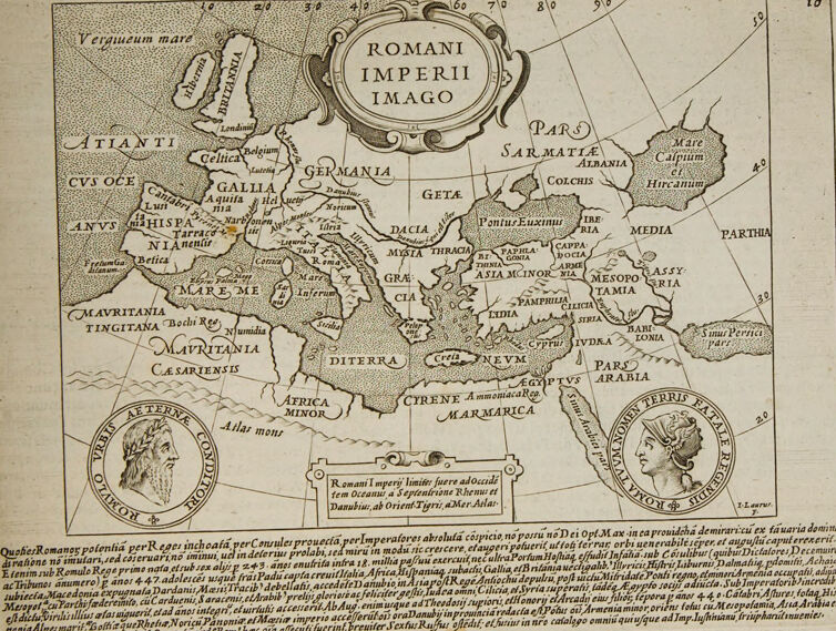
The image depicts an old map titled "ROMANI IMPERII IMAGO" which translates to "Image of the Roman Empire". The map illustrates the vast expanse of the Roman Empire at a certain period in history, showcasing various regions such as "GALLIA" (Gaul), "HISPANIA" (Spain), "GERMANIA" (Germany), "AFRICA", and parts of Asia including "ASIA MINOR" and "INDIA". Notably, there are two inset medallion portraits located towards the bottom of the map. Each medallion appears to feature a classical figure, possibly important personalities from Roman history. The map is adorned with elaborate detail and the geographical names are written in Latin. Surrounding the map, there is textual content, again in Latin, which seems to provide context or commentary on the Roman Empire. Overall, the map emanates a sense of antiquity and historical significance, typical of cartographic representations from the Renaissance period or thereabouts.
Created by gpt-4o-2024-05-13 on 2025-02-12
This image depicts an old map titled "Romani Imperii Imago," which translates to "Image of the Roman Empire." The map illustrates the expanses of the ancient Roman Empire, depicting various regions and territories under Roman control. Notable areas such as Gallia, Germania, Hispania, and Italia are clearly marked. The map also shows neighboring regions like Parthia and Sarmatia. The map is ornately decorated with a baroque cartouche presenting the title and includes two medallion-like illustrations, one with a figure in profile in the bottom left corner and another obfuscated figure toward the bottom right. Additionally, there is a detailed Latin text at the bottom of the page providing historical context about the Roman Empire.
Anthropic Claude
Created by us.anthropic.claude-3-5-sonnet-20241022-v2:0 on 2025-06-26
This is a historical map titled "Romani Imperii Imago" (Image of the Roman Empire). It's an antique map showing the extent of the Roman Empire, including regions like Germania, Britannia, Mauritania, Asia Minor, and various other territories. The map features decorative elements including two medallion portraits in the bottom corners, likely depicting Roman rulers or historical figures wearing laurel wreaths.
The map is drawn in a classical style with Latin text and place names. The Mediterranean Sea (Mare Me[diterraneum]) is prominently featured in the center, with Europe to the north, Africa to the south, and Asia to the east. There's detailed Latin text at the bottom of the map providing historical information about the empire.
The cartography is relatively simple but elegant, with stippled seas and basic geographic outlines. Various regions and provinces are clearly labeled, showing the vast extent of Roman influence from Britain to Egypt and from the Atlantic Ocean to the Middle East. The map appears to be from a historical atlas or educational text, likely dating from the 16th or 17th century based on its style and execution.
Created by claude-3-5-sonnet-20241022 on 2025-02-12
This is a historical map titled "ROMANI IMPERII IMAGO" (Image of the Roman Empire). It's an antique map showing the extent of the Roman Empire, including regions like Germania, Sarmatia, Parthia, Mauritania, and various other ancient territories. The map is drawn in a classical style with decorative elements including two medallion portraits in the bottom corners that appear to be of Roman figures wearing laurel wreaths.
The Mediterranean Sea (labeled as "MARE ME") is prominently featured in the center, with Europe to the north, Africa to the south, and Asia to the east. Various regions and provinces are labeled in Latin text. The map includes the Atlantic Ocean (labeled as "ATLANTICVS OCE") on the western edge and extends eastward to include parts of Asia.
At the bottom of the map, there is a substantial text block in Latin that likely provides historical context about the Roman Empire. The overall design is typical of Renaissance-era cartography, with ornamental cartouches and a clean, engraved style. The map appears to be in good condition despite its age, with slight yellowing of the paper visible.
Created by claude-3-opus-20240229 on 2025-02-12
This image depicts a historical map of the Roman Empire, titled "Romani Imperii Imago". The map shows the various regions and cities that made up the empire, spanning across Europe, North Africa and the Middle East. The map includes intricate details and labels for each location. In the corners of the map, there are two portrait cameos depicting a man and a woman, likely important figures from that era, though I cannot identify them specifically. Below the map is a block of text in Latin, probably providing additional context or explanation about the Roman Empire and the map itself.
Created by claude-3-haiku-20240307 on 2025-02-12
This image appears to be an antique map showing the Roman Empire during its heyday. The map is labeled "Romani Imperii Imago", which translates to "Image of the Roman Empire" in Latin. It depicts various regions, territories, and geographic features that were part of the expansive Roman Empire, including Germania, Gallia, Hispania, Africa, and others. The map contains detailed labels and annotations in Latin, as was common for cartography from that time period. It provides a comprehensive view of the Roman world as it was understood and depicted centuries ago.
Meta Llama
Created by us.meta.llama3-2-11b-instruct-v1:0 on 2025-03-13
The image is a map of the Roman Empire, titled "ROMANI IMPERII IMAGO" in the top center. The map is surrounded by a decorative border and features a key or legend at the bottom, although the text is too small to read.
Map Features:
- The map depicts the Roman Empire, including its provinces and territories.
- The empire is divided into regions, with some areas labeled with their names in Latin.
- The map also shows the location of major cities, such as Rome, Alexandria, and Carthage.
- The Mediterranean Sea is prominently featured, with several islands and coastlines visible.
Decorative Elements:
- A circular emblem with the title "ROMANI IMPERII IMAGO" is located at the top center of the map.
- Two circular portraits of Roman emperors are placed at the bottom left and right corners of the map.
- The map is surrounded by a decorative border, which adds to its aesthetic appeal.
Overall:
- The map appears to be a historical representation of the Roman Empire during its peak, showcasing its vast territories and provinces.
- The level of detail and the use of Latin labels suggest that the map was created for an audience familiar with classical history and geography.
- The decorative elements, such as the circular emblems and portraits, add a touch of elegance and sophistication to the map.
Created by us.meta.llama3-2-90b-instruct-v1:0 on 2025-03-13
The image depicts a map of the Roman Empire, titled "ROMANI IMPERII IMAGO" in Latin. The map is drawn in black ink on a beige background and features various geographical features such as mountains, rivers, and coastlines. The map also includes several place names, including cities, provinces, and regions.
In the top-left corner of the map, there is a small inset map that appears to be a zoomed-in view of a specific region. The inset map is surrounded by a decorative border and includes several place names and geographical features.
At the bottom of the map, there is a large block of text written in Latin. The text appears to be a description or explanation of the map, but it is not clear what specific information it provides.
Overall, the image suggests that the map is an historical representation of the Roman Empire, possibly created during the Renaissance period. The use of Latin and the decorative border around the inset map suggest a level of sophistication and attention to detail that was characteristic of Renaissance cartography.
Amazon Nova
Created by amazon.nova-pro-v1:0 on 2025-02-12
The image is a historical map of the Roman Empire, titled "Romani Imperii Imago," which translates to "Image of the Roman Empire." The map is presented in a sepia tone, indicating its age and historical significance. The map is framed by decorative borders and includes a title cartouche at the top center, which is adorned with classical motifs and the Latin inscription "Romani Imperii Imago."
The map itself is divided into several regions, each labeled with Latin names. Notable regions include "Germania," "Gallia," "Hispania," "Italia," "Africa," "Asia," and "Aegyptus." The Mediterranean Sea is prominently featured in the center, with the Italian Peninsula at its heart. The map also includes the British Isles, labeled as "Britannia," and the Iberian Peninsula, labeled as "Hispania."
The map includes a scale of miles at the bottom center, indicating the distances between various locations. Additionally, there are two circular vignettes on either side of the map, one featuring a bearded figure with a laurel wreath and the other depicting a woman in a headdress. These vignettes likely represent classical figures or allegorical representations of the empire.
The map is surrounded by text in Latin, which provides additional information about the regions depicted and possibly the historical context of the Roman Empire at the time the map was created. The overall design and presentation of the map suggest it was intended for educational or decorative purposes, highlighting the vast extent and influence of the Roman Empire.
Created by amazon.nova-lite-v1:0 on 2025-02-12
The image shows an antique map of the Roman Empire from the 17th century. The map depicts the vast territories of the Roman Empire at its height, covering much of Europe, North Africa, and parts of Asia. The map is framed by decorative borders and features intricate details, including the names of provinces, cities, and geographical features. The map is accompanied by a Latin inscription that provides historical context and information about the Roman Empire. The map is printed on aged paper, giving it an antique and historical appearance.
Google Gemini
Created by gemini-2.0-flash on 2025-05-23
Here is a description of the image:
The image is a scanned page from an old book, featuring a map titled "ROMANI IMPERII IMAGO" (Image of the Roman Empire). The map is centered on the Mediterranean Sea, with depictions of Europe, North Africa, and the Middle East.
Key features on the map include:
- Geographical Locations: Names such as Hibernia (Ireland), Britannia (Britain), Germania, Gallia (France), Hispania (Spain), Dacia, Asia Minor, Egyptvs (Egypt), and Arabia are marked. The map includes the seas and regions known during the Roman Empire.
- Decorative Cartouches: There is a decorative cartouche around the title of the map. Below the map, there are two medallion portraits within cartouches, one of a bearded man and the other of a woman wearing a diadem or similar headpiece.
- Text: Below the medallions, there is a block of dense, small-font text in Latin or a similar language.
The page shows signs of aging, with yellowing and slight damage at the edges. The printing style suggests it is from a historical publication.
Created by gemini-2.0-flash-lite on 2025-05-23
This is an antique map of the Roman Empire, titled "ROMANI IMPERII IMAGO" (Image of the Roman Empire). It is a historical representation of the empire's extent, showing its geographical reach across Europe, North Africa, and the Middle East. The map is in Latin, with place names written in the language of the time.
Here are some key features and observations:
- Geographical Extent: The map depicts the Roman Empire's territory, including regions like Britannia, Gallia (France), Germania, Hispania (Spain), and parts of North Africa. It also shows areas further east, such as the Eastern Mediterranean, Middle East, and Black Sea regions.
- Cartographic Style: The map has a detailed, illustrative style characteristic of historical cartography. It is likely an engraving. Features like coastlines, rivers, and major mountain ranges are represented.
- Labels and Inscriptions: The map is filled with place names, with regions and key cities labeled in Latin. The cartouche includes the title and perhaps additional information.
- Decorative Elements: There are decorative elements such as cartouches, shields, and text. It also features portraits of Roman figures.
- Text: There is accompanying text along the bottom that seems to describe the rise and expansion of the Roman Empire.
- Historical Context: This map provides a valuable glimpse into how the Roman Empire was understood and presented in the past. The date is likely from the 16th or 17th century, based on the style of the map.
The map is a significant historical artifact, offering insights into the cartographic and historical knowledge of the time, as well as the perceived scope and significance of the Roman Empire.
Mistral Pixtral
Created by us.mistral.pixtral-large-2502-v1:0 on 2025-06-08
The image is a historical map titled "Romani Imperii Imago," which translates to "Image of the Roman Empire." It appears to be a representation of the Roman Empire during its height, showcasing various regions and territories under Roman control. Here are some detailed observations:
Geographical Coverage:
- The map covers a broad area, including parts of Western Europe, Northern Africa, and the Middle East.
- Key regions labeled include Britannia (Britain), Gallia (Gaul, modern-day France), Hispania (Spain), Germania (Germany), Italia (Italy), Graecia (Greece), Asia (Asia Minor, modern-day Turkey), Syria, and Aegyptus (Egypt).
Notable Features:
- The map includes various bodies of water such as the Atlantic Ocean (labeled as "Oceanus Atlanticus"), the Mediterranean Sea (labeled as "Mare Internum"), and the Black Sea (labeled as "Pontus Euxinus").
- Major rivers like the Rhine (Rhenus) and the Danube (Danubius) are also depicted.
Cities and Provinces:
- Prominent cities and provinces are marked, including Roma (Rome), Paris (Paris), Londinium (London), and Alexandria (Alexandria).
- The map also includes less familiar regions and cities, indicating the extensive reach of the Roman Empire.
Artistic Elements:
- There are two circular portraits at the bottom of the map. One depicts a Roman figure, likely an emperor, with the inscription "Divus Augustus" (Divine Augustus). The other portrait is of a female figure, possibly representing a Roman goddess or empress.
- The map is adorned with decorative elements, such as the ornate title cartouche at the top center.
Textual Information:
- At the bottom of the map, there is a block of text in Latin, providing a description or commentary about the Roman Empire. This text likely discusses the extent of the empire, its provinces, and possibly its achievements.
Scale and Orientation:
- The map includes a scale at the top, indicating distances in Roman miles.
- The orientation is typical for historical maps, with north at the top.
This map serves as a historical artifact, illustrating the vast territorial extent of the Roman Empire and providing insights into the geopolitical landscape of that era.
Qwen
No captions written
Text analysis
Amazon