Machine Generated Data
Tags
Color Analysis
Feature analysis
Amazon
Clarifai
AWS Rekognition
| Poster | 79.1% | |


Categories
Imagga
created on 2022-01-16
| paintings art | 100% | |
Captions
Microsoft
created by unknown on 2022-01-16
| map | 100% | |
Clarifai
Created by general-english-image-caption-clip on 2025-07-14
map of the region by person.
Salesforce
Created by general-english-image-caption-blip on 2025-05-20
a photograph of a drawing of a map of germany
OpenAI GPT
Created by gpt-4o-2024-11-20 on 2025-06-10
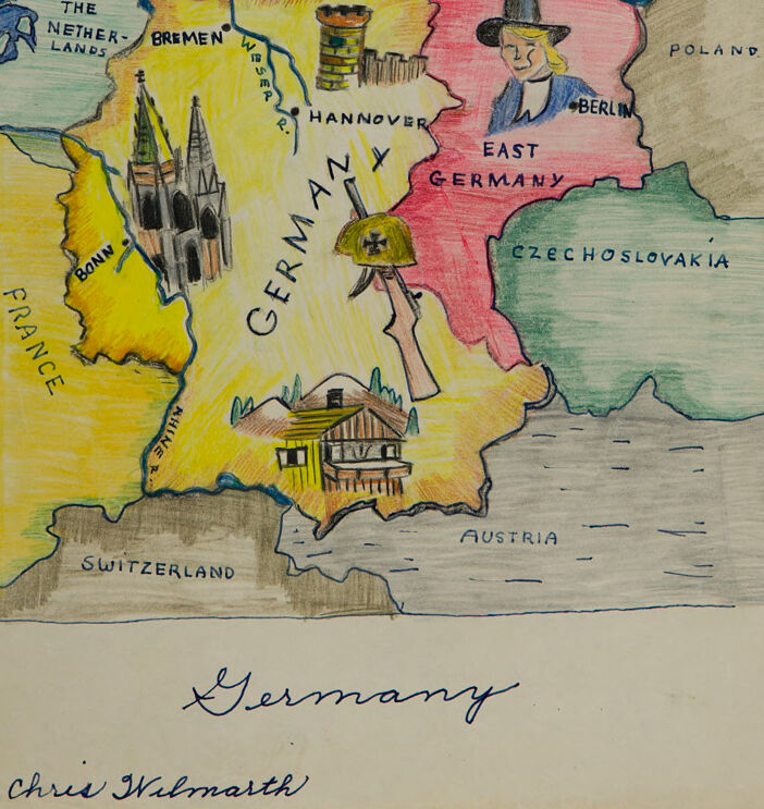
This image depicts a hand-drawn map of Germany, featuring details that seem to represent geographical and cultural markers. The country is split into two sections: West Germany (yellow) and East Germany (red/pink), reflecting the division during the Cold War era. Various landmarks and symbols are included:
West Germany:
- A cathedral in Bonn representing historic architecture.
- A timbered house near Switzerland and Austria, possibly symbolizing traditional German homes.
- A helmet with a sword marked "Germany," potentially representing military history or identity.
East Germany:
- A figure wearing a top hat near Berlin, perhaps symbolizing the capital or a cultural aspect specific to the area.
Surrounding countries are labeled (e.g., Poland, Czechoslovakia, France, and The Netherlands). The map is accented with colored pencil shading and annotations. At the bottom, the word "Germany" is written in cursive, along with the name "Chris Wilmarth," presumably the creator of the drawing.
Created by gpt-4o-2024-08-06 on 2025-06-10
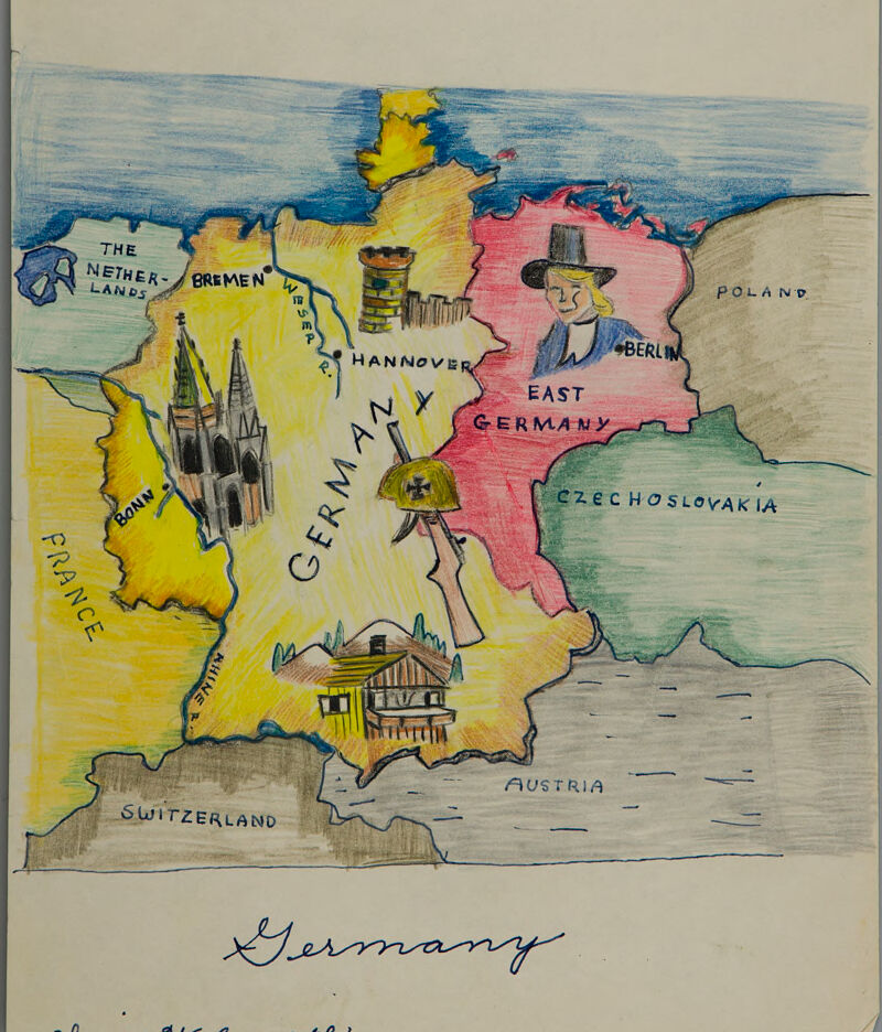
The image is a hand-drawn and colored map titled "Germany" that appears to be drawn by someone named Chris Wilmarth, as indicated by text at the bottom of the image. The map depicts Germany and some of its surrounding countries in a stylized manner. Germany is divided into two parts: "West Germany," colored in yellow, and "East Germany," colored in red.
"West Germany" includes notable cities such as Bonn, Bremen, and Hannover. Illustrations include the Cologne Cathedral near Bonn represented as tall pointed structures and a beer stein near Hannover.
"East Germany" features Berlin, illustrated by a person in traditional German attire, including a hat, in the area marked as Berlin.
The map is bordered by several countries:
- France to the southwest
- Switzerland to the south
- Austria to the southeast
- Czechoslovakia and Poland to the east
- The Netherlands to the northwest
Denmark is partially visible at the top, above Germany, separated by a water body. The map artistically represents geographical features and landmarks and uses bright colors, such as yellow for West Germany, red for East Germany, light blue for the water, and other colors for the surrounding countries.
Anthropic Claude
Created by anthropic.claude-3-haiku-20240307-v1:0 on 2025-06-15
The image appears to be a hand-drawn map of Germany and the surrounding regions. It depicts the division of Germany into East and West, with the city of Berlin highlighted. The map includes the neighboring countries of Poland, Czechoslovakia, Austria, and Switzerland, as well as the cities of Bremen, Hannover, and other locations within Germany. The map is colorfully illustrated with various landmarks and symbols, such as church steeples, mountains, and a figure wearing a hat. The overall style suggests this is a personal or educational map, rather than a professional cartographic work.
Created by us.anthropic.claude-3-5-sonnet-20241022-v2:0 on 2025-06-15
This is a hand-drawn map of divided Germany, likely from the Cold War era. The map shows West Germany colored in yellow and East Germany in pink. Various iconic symbols are illustrated across the map, including:
- The Bremen Cathedral or similar Gothic church architecture in Bremen
- A traditional Alpine-style house in southern Germany
- A military helmet with an Iron Cross symbol
- A figure wearing what appears to be a hat in the East German (Berlin) region
The map is bordered by neighboring countries including:
- The Netherlands to the northwest
- France to the west
- Switzerland and Austria to the south
- Czechoslovakia to the southeast
- Poland to the east
Cities like Bremen, Hannover, and Berlin are labeled. The artwork is done in colored pencil or similar medium, with a simple but effective style. The title "Germany" is written in cursive below the map, along with what appears to be an artist's signature "Chris Walmarth".
Meta Llama
Created by us.meta.llama3-2-11b-instruct-v1:0 on 2025-06-10
The image depicts a hand-drawn map of Germany, showcasing its geographical features and notable landmarks. The map is rendered in a colorful and detailed style, with various elements that provide insight into the country's history and culture.
- Map Features:
- The map is drawn on a beige background, with the country of Germany prominently displayed in yellow.
- The map features several notable landmarks, including:
- The Netherlands
- Bremen
- Hannover
- Bonn
- France
- Switzerland
- Austria
- Czechoslovakia
- Poland
- Berlin
- East Germany
- The map also includes illustrations of various objects, such as:
- A church
- A house
- A soldier
- A top hat
- A hammer and sickle
- Color Scheme:
- The map features a range of colors, including:
- Yellow (Germany)
- Blue (the Netherlands, France, and Poland)
- Red (East Germany)
- Green (Czechoslovakia)
- Brown (Austria)
- Gray (Switzerland)
- The map features a range of colors, including:
- Handwriting:
- The map is signed "Chris Wilmarth" in blue ink at the bottom.
- Overall Impression:
- The map appears to be a personal and creative representation of Germany, with a focus on its geographical features and cultural landmarks.
- The use of color and illustration adds a playful and engaging touch to the map, making it a unique and interesting piece of art.
Created by us.meta.llama3-2-90b-instruct-v1:0 on 2025-06-10
This image is a hand-drawn map of Germany, created by Chris Wilmarth. The map features a colorful and whimsical design, with various regions and landmarks depicted in different colors and illustrations.
Map Features:
- The map includes several notable cities, such as Berlin, Hannover, Bremen, and Munich.
- The borders of neighboring countries, including France, Switzerland, Austria, Czechoslovakia, Poland, and the Netherlands, are also shown.
- A prominent illustration of a man wearing a top hat and coat is located in the eastern part of the country.
- A church or cathedral is depicted in the southwestern region.
- A house or building is shown in the southern part of the country.
- A military helmet and rifle are illustrated in the center of the map.
Color Scheme:
- The map features a predominantly yellow background, with various regions highlighted in different colors, including red, green, blue, and brown.
- The illustrations and text are drawn in black ink, with some additional details added in color.
Overall Impression:
- The map appears to be a creative and artistic representation of Germany, rather than a strictly accurate or detailed geographical depiction.
- The use of bright colors and whimsical illustrations gives the map a playful and imaginative feel.
- The inclusion of various landmarks and symbols adds depth and interest to the map, making it a visually engaging and thought-provoking piece.
Amazon Nova
Created by amazon.nova-lite-v1:0 on 2025-06-06
The image is a hand-drawn map of Germany with various annotations and illustrations. The map is colored in different shades of yellow, pink, green, and blue. The country is labeled as "Germany" at the top, and its neighboring countries are labeled as "The Netherlands," "France," "Switzerland," "Austria," "Poland," and "Czechoslovakia." The map also includes illustrations of buildings, a soldier with a helmet, and a city skyline. The artist's name, "Chris Wilmarth," is written at the bottom of the map.
Created by amazon.nova-pro-v1:0 on 2025-06-06
The image is a hand-drawn map of Germany and its surrounding countries, including Poland, Czechoslovakia, Austria, Switzerland, France, and the Netherlands. The map is drawn with colored pencils and crayons, giving it a vintage and artistic look. The map shows the borders of Germany and its neighboring countries, along with some of the major cities and landmarks within Germany. The map also includes a drawing of a soldier wearing a helmet and holding a rifle, which may represent the military history of Germany. The map is titled "Germany" and is signed by the artist, Chris Wilmart.
Google Gemini
Created by gemini-2.0-flash on 2025-05-02
Here's a description of the image:
The image is a hand-drawn, colored map of Germany and some of its surrounding countries. It appears to be a historical map, likely from the Cold War era, as it depicts "East Germany" as a distinct area.
The map is colored with a combination of yellow, red, green, and blue. Germany itself is predominantly yellow, with "East Germany" colored in red. Surrounding countries like France, the Netherlands, Poland, Czechoslovakia, and Austria are drawn in shades of green and grey. The sea areas above Germany are colored light blue.
Several landmarks and symbols are drawn on the map. These include a cathedral near Bonn, a castle near Hannover, a traditional Alpine chalet in the southern part of Germany, and a German military helmet and weapon in the center. Additionally, there is a cartoonish representation of a person wearing a top hat within the boundaries of "East Germany," near Berlin.
Labels are handwritten in blue ink, identifying the countries and cities. At the bottom of the image, the word "Germany" is written in a stylized cursive, followed by the name "Chris Wilmarth".
Created by gemini-2.0-flash-lite on 2025-05-02
Here's a description of the image:
The image is a hand-drawn, colored pencil map of Germany and its surrounding countries, possibly from the mid-20th century. It depicts a divided Germany.
Key Features:
- Color-Coded: The map uses different colors to delineate geographical areas. Germany is primarily yellow and red. East Germany is shaded in red. Neighboring countries such as France, Switzerland, Czechoslovakia, Poland, Austria, and The Netherlands are also indicated.
- Divided Germany: The use of the red and yellow to mark the two regions of Germany likely represents the division of Germany after World War II. The city of Berlin is featured as a specific location inside the red region (East Germany).
- Illustrations: The map includes small, hand-drawn illustrations to represent some cities and iconic sites:
- A large Gothic cathedral, to show Bonn.
- A castle tower to show Hannover.
- A drawing of a house with a balcony to show the Southern of Germany.
- A soldier's helmet and rifle.
- Labels: Countries and important cities are clearly labeled with handwritten text.
- Handwritten Text: Below the map, the word "Germany" is written in script, and the name "Chris Wilmarth" appears at the bottom.
Overall Impression:
The map has a charming, somewhat naive, aesthetic. The use of colored pencils and the hand-drawn style gives it a personal and educational feel. It likely was created as a learning tool or personal project.
Mistral Pixtral
Created by us.mistral.pixtral-large-2502-v1:0 on 2025-06-03
The image is a hand-drawn, colorful map of Germany and its surrounding countries. It appears to be a whimsical and artistic representation rather than a precise geographical map. Here are the details:
Geographical Features and Countries:
- Germany is centrally located and labeled prominently. It is divided into two parts: West Germany (yellow) and East Germany (red).
- Surrounding countries are labeled:
- The Netherlands (top left)
- France (bottom left)
- Switzerland (bottom left)
- Austria (bottom right)
- Czechoslovakia (right)
- Poland (top right)
Cities and Landmarks:
- Bremen is marked in the northwestern part of Germany.
- Hannover is labeled in the northern part of West Germany.
- Berlin is depicted in East Germany with a caricature of a person wearing a top hat.
- Bonn is marked in West Germany.
- Munich (München) is shown in the southern part of West Germany.
- The map includes illustrations of iconic landmarks:
- A cathedral (likely Cologne Cathedral) near Bonn.
- A traditional Bavarian-style house near Munich.
- A barrel of beer in the northern part of Germany.
- A military helmet with a cross symbol in the central part of Germany.
Artistic Elements:
- The map uses bright colors: yellow for West Germany, red for East Germany, green for Czechoslovakia, and various shades for other countries.
- The illustrations are playful and cartoonish, adding a light-hearted touch to the map.
- The word "Germany" is written in large, bold letters across the center of the country.
Signature:
- The map is signed "Chris Wilmarth" at the bottom.
Overall, the image is a creative and colorful representation of Germany and its neighboring countries, with a focus on notable cities and landmarks.
Qwen
Created by Qwen/Qwen2.5-VL-7B-Instruct on 2025-07-11
The image is a hand-drawn map of Germany and its neighboring countries. The map is labeled "Germany" at the bottom, and the artist's name, "Chris Walmarth," is signed at the bottom left. Key features include:
- The map is colored in yellow and pink sections to distinguish West Germany (yellow) from East Germany (pink).
- Major cities and regions are labeled, such as Berlin (in East Germany), Bonn (in West Germany), Hannover, and Bremen.
- Landmarks and cultural elements are illustrated, including:
- A church in Bonn.
- A castle in Hannover.
- A character wearing a hat resembling a traditional Germanic hat in Berlin.
- A military helmet with a cross, possibly symbolizing the German military.
- A wooden hut, possibly representing rural or Alpine architecture.
- Borders with neighboring countries are labeled:
- France to the west.
- The Netherlands to the northwest.
- Poland to the northeast.
- Czechoslovakia to the east.
- Austria to the southeast.
- Switzerland to the south.
The map is in a whimsical, cartoonish style, with exaggerated and colorful representations of landmarks and regions.
Created by Qwen/Qwen2.5-VL-72B-Instruct on 2025-07-11
This image is a hand-drawn, colorful map of Germany, divided into two main regions: West Germany and East Germany. The map is labeled with various cities, including Bremen, Hannover, Berlin, and Bonn.
Key features of the map include:
- The western part of Germany is colored yellow and contains illustrations of landmarks such as a church and a castle. It is bordered by France, Switzerland, and the Netherlands.
- The eastern part of Germany is colored red and features an illustration of a man wearing a hat and a uniform, possibly a soldier, holding a hat with a military emblem. It is bordered by Poland and Czechoslovakia.
- The map is drawn on a piece of paper and appears to be hand-drawn with colored pencils or markers.
- The title "Germany" is written at the bottom of the map, along with the name "Chris Walmarth," presumably the artist who created the map.
Text analysis
Amazon