Machine Generated Data
Tags
Color Analysis
Categories
Imagga
| text visuals | 87.7% | |
| interior objects | 12% | |
Captions
Microsoft
created on 2020-04-26
| a black and white photo of a person | 64% | |
| a black and white photo | 63.9% | |
| a black and white photo of a room | 63.8% | |
OpenAI GPT
Created by gpt-4 on 2025-03-09
This is an image of a framed document or map. The document is black and white and features a series of lines and geometric shapes, possibly representing a schematic or layout of an architectural site or an area. There are labels written in a language that appears to be German, mentioning "Bauhaus" and "Walter Gropius." This suggests that the content of the document is related to the Bauhaus art school or a project associated with Walter Gropius, a renowned architect associated with this movement. On the lower left corner of the document, there's a scale indication, which suggests that the document is a scaled drawing. The lower right corner has annotations, likely related to the document's content or purpose. At the bottom of the image, there's a number "48.2", which might be an archive, inventory, or figure number for reference. The document is mounted on a larger dark matte and framed with a simple black frame, indicating that it is displayed as a piece of art or historical artifact. The photograph itself is taken at an angle, as evident from the perspective distortion of the frame. Overall, the image is a capture of historical significance, likely related to architecture and design.
Created by gpt-4o-2024-05-13 on 2025-03-09
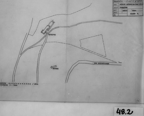
The image depicts an architectural drawing or site plan. This black and white image is presented within a black frame, and appears to be a schematic overview showing various lines and markings that likely represent paths, roads, or boundaries in a specific area. At the top right of the drawing, there is a title block which contains the text "bauatelier: prof. walter gropius," indicating that the drawing was created by the architectural office of the famous architect Walter Gropius. Additional information in the title block includes "schule schwarzenberg / exck" and "maßstab 1:2000" suggesting that the drawing is related to a school in Schwarzenberg, with a scale of 1:2000. The plan itself features the word "Eingang" (German for "Entrance") near a rectangular structure, possibly representing a building. Pathways or roads extending towards different directions are also marked, with an arrow labeled "Norden" guiding the direction towards the north. Another annotation on the plan says "von Joppenshausen," possibly referring to an area or direction from which a road or path originates. The image is labeled with a small tag "48.2" in the bottom right-hand corner, likely an index or catalog number related to the archival system.
Anthropic Claude
Created by claude-3-haiku-20240307 on 2025-01-13
The image appears to be a technical drawing or map of a building or structure. The drawing contains various geometric shapes and lines, suggesting it is an architectural or engineering plan. The text in the image indicates it is a "Baustelletz" or construction site plan. The plan outlines the layout and features of the structure, including some labeled structures or elements. Overall, the image seems to be a detailed technical drawing or plan related to a construction or engineering project.
Created by claude-3-5-sonnet-20241022 on 2025-01-13
This appears to be a simple technical drawing or map showing some roads or pathways and building locations. The drawing is in black and white and appears to be a scan or photograph of an original document. There are some German words visible on the drawing, and it has what looks like a reference number "48.2" in the corner. The drawing shows curved lines that could represent roads or paths, and there are a few small rectangles that might indicate buildings or structures. The image has a form or label box in the top right corner with some text fields. The overall style suggests this is likely a historical planning or survey document.
Created by claude-3-opus-20240229 on 2025-01-13
The image appears to be a hand-drawn map or diagram showing the layout of some roads or paths. There are curved lines representing what seem to be roads or trails, with labels such as "väg" (which means "road" in Swedish) and "stig" (which means "path" or "trail" in Swedish). The roads intersect and branch off at various points. In the bottom right corner, there is a label that says "48.2", likely indicating a distance or measurement related to the depicted area. The top right corner contains a small table with Swedish labels, possibly providing a legend or additional details about the map. The image is in black and white and has a vintage or aged appearance, with the paper showing some discoloration or fading. It is presented in a black frame, suggesting it may be an old archived document or sketch.
Meta Llama
Created by us.meta.llama3-2-90b-instruct-v1:0 on 2025-01-13
The image depicts a black-and-white map of a region, likely a rural area, with several roads and buildings. The map is drawn in black ink on white paper and features a key in the top-right corner that appears to be written in German. The map shows several roads, including a main road that runs through the center of the image, as well as several smaller roads that branch off from it. There are also several buildings shown on the map, including what appears to be a church or other religious building in the center of the image. The map also includes some text, including the words "Kapung" and "von Poppelsheim," which may refer to specific locations or features on the map. Overall, the image suggests that the map is a detailed representation of a specific geographic area, possibly created for planning or navigation purposes.
Created by us.meta.llama3-2-11b-instruct-v1:0 on 2025-01-13
The image presents a black-and-white map, likely created in the 20th century, featuring a rectangular shape with a folded top-left corner. The map is surrounded by a thick black border, and a white label with the handwritten number "48.2" is visible in the bottom-right corner. **Key Features:** * **Map Content:** The map appears to depict a landscape with roads, buildings, and other features, although the exact location or purpose of the map is unclear. * **Border and Label:** The thick black border provides a clear outline for the map, while the white label with the handwritten number "48.2" suggests that this may be a reference or identification number. * **Background:** The background of the image is a light gray color, which helps to highlight the details of the map. **Overall Impression:** The image suggests that the map was created for a specific purpose, such as navigation or planning, and may have been used in a professional or official context. The use of a black-and-white format and the inclusion of a reference number on the label suggest that the map may have been created using traditional methods, such as hand-drawn or typed text.
Amazon Nova
Created by amazon.nova-pro-v1:0 on 2025-01-13
The image depicts a framed document, possibly a map or a technical drawing, presented in black and white. The frame is simple and dark, providing a clear contrast to the lighter document inside. The document itself appears to be a technical drawing or a map, as indicated by the presence of lines, labels, and annotations. There are various elements within the drawing, including what seems to be a river, roads, and possibly buildings or other structures. The drawing is detailed, with numerous lines and labels that suggest specific locations or features. There is a table on the right side of the document with columns and rows, possibly indicating data related to the map or drawing. At the bottom right corner of the document, there is a number "48.2" written in a rectangular box, which could be a reference number or a page number. The overall appearance of the document suggests it is a professional or technical document, possibly used for planning, engineering, or geographical purposes.
Created by amazon.nova-lite-v1:0 on 2025-01-13
The image appears to be a technical drawing or architectural plan, possibly related to construction or engineering. The drawing is framed within a black border and contains a table with various columns and rows of text. The table includes labels such as "baustelle," "waler," "gropius," "bau," "schulle," "sehmarsorden," "shop," "pepe," "lagglen," "ger," "sabhol," "Zone," and "Dap." The table also has a column labeled "blatt: 5." The drawing itself depicts a structure or building, with labels such as "Alampang," "vor poppenheim," and "nordan" indicating different parts or features of the structure. The drawing is accompanied by a number "48.2" in the lower right corner. Overall, the image suggests a technical or engineering context, possibly related to the design or construction of a building or structure.
Text analysis
Amazon