Machine Generated Data
Tags
Color Analysis
Categories
Imagga
| paintings art | 72.2% | |
| streetview architecture | 8.5% | |
| text visuals | 7.5% | |
| interior objects | 7% | |
| cars vehicles | 2.9% | |
Captions
Microsoft
created on 2020-04-26
| a screen shot of a person | 34.6% | |
| a sign on a wall | 34.5% | |
OpenAI GPT
Created by gpt-4 on 2025-03-06
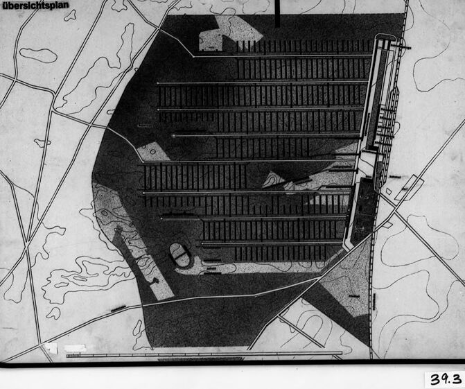
This is an image of a framed architectural drawing or plan. The drawing depicts a bird's-eye perspective of what appears to be an urban development plan or a complex building layout. On the left side, there is text that reads "Übersichtsplan," which is German for "overview plan" or "master plan." The plan shows multiple parallel lines suggesting buildings or blocks, and a more detailed structure on the right side with multiple layers or levels, possibly depicting a tiered building or a section of a larger structure. The layout includes an array of neatly arranged rectangles, which might illustrate rooms, units, or other planned spaces. There is a vertical arrow on the right-hand side, likely indicating the direction of north. Linear features that resemble roads or paths seem to connect and intersect around the main structure. Dotted lines also indicate perhaps pedestrian routes or less prominent pathways. Natural elements in the drawing include wavy lines that might represent water bodies. The drawing is monochromatic, using shading techniques to highlight depth and the three-dimensional aspects of the design. The picture is taken at an angle where we can see the photo frame edges and some wall mounting fixtures. There is also a label in the lower right corner with the number "39.3," which could refer to an archive or inventory number associated with the drawing.
Created by gpt-4o-2024-05-13 on 2025-03-06
The image is a black and white photo of a map or a plan labeled "Übersichtsplan" in German, which translates to "overview plan" in English. The map appears to show a large, dense area filled with parallel lines likely representing railway tracks or parking lots, extending across the middle section of the map. The surrounding areas outside this dense dark section show lighter regions with lines that look like roads or pathways and some irregular shapes that might represent natural features such as bodies of water, forests, or fields. There is a prominent arrow pointing upwards (North), indicating the orientation of the map. The map is encased in a frame, possibly glass or plastic, and is affixed with some sort of tape or binding on the left and right sides. There is a small label or tag on the bottom right corner with the numbers "39.3" which could denote a reference or catalog number.
Anthropic Claude
Created by claude-3-5-sonnet-20241022 on 2025-01-13
This appears to be a black and white architectural or site plan labeled "Ubersichtsplan" (German for "overview plan" or "layout plan"). The image shows what appears to be a large facility with multiple parallel linear structures or barracks arranged in rows. The plan is oriented with an arrow pointing north, and shows various roads or paths around the perimeter. The central area is shaded darker, with the structures clearly visible as parallel lines. This type of document appears to be a technical or architectural drawing, possibly of a military or institutional facility. The style and format suggests this may be a historical document, possibly from the mid-20th century.
Created by claude-3-opus-20240229 on 2025-01-13
The image appears to be a black and white architectural plan or map of some kind of structure, possibly a building or complex. The plan shows a roughly hexagonal shape divided into various sections or rooms, with lines indicating walls, stairs, or other structural elements. A grid overlays the plan, possibly for scale or measurement purposes. The label "Oberster gesplan" is written at the top, which seems to be German, though I don't know the exact meaning. The number "39.3" is written at the bottom of the plan. Overall, it looks like a technical drawing or blueprint depicting the layout and design of an unspecified structure.
Created by claude-3-haiku-20240307 on 2025-01-13
The image appears to be a black and white architectural plan or schematic drawing. It shows a complex structure with multiple levels or floors, depicted with a series of horizontal lines. The drawing also includes some curved or angled lines, as well as a few rectangular shapes that may represent additional features or elements of the structure. The overall composition has an abstract, geometric quality, with the dark and light contrasts creating a striking visual effect.
Meta Llama
Created by us.meta.llama3-2-90b-instruct-v1:0 on 2025-01-13
The image is a black-and-white map or plan, likely an architectural or urban planning design. The map features a large, dark-colored area with numerous lines and shapes, possibly representing buildings, roads, or other infrastructure. A smaller, lighter-colored section is visible in the top-left corner, which may indicate a specific location or feature. In the bottom-right corner, the number "34.3" is written in black ink, suggesting that this might be a page or section number from a larger document or report. The overall appearance of the image suggests that it is a technical drawing or blueprint, possibly created for a construction project or urban development initiative.
Created by us.meta.llama3-2-11b-instruct-v1:0 on 2025-01-13
The image is a black-and-white architectural drawing of a building, likely a plan or blueprint. It features a large, rectangular structure with multiple levels and a parking lot in front. * The building has a flat roof and a long, horizontal facade with many windows. * There are several staircases and elevators leading to different levels of the building. * The parking lot is located in front of the building and has several parking spaces marked on it. * The background of the drawing shows a map of the surrounding area, with roads and other buildings visible. * The overall design of the building appears to be modern and functional, with a focus on efficiency and practicality. The image provides a detailed view of the building's layout and design, allowing the viewer to understand its purpose and functionality.
Amazon Nova
Created by amazon.nova-lite-v1:0 on 2025-01-13
The image appears to be a black-and-white photograph of a framed map or architectural plan. The map is titled "Übersichtsplan" and has a number "39.3" in the bottom right corner. The map shows a layout of a building or complex, with various rooms, corridors, and areas marked out. There are also some arrows and lines indicating different directions or pathways. The map appears to be a detailed and precise representation of the layout, with a scale or legend in the upper left corner. Overall, the image suggests that it is a technical or professional document, possibly used for planning or construction purposes.
Created by amazon.nova-pro-v1:0 on 2025-01-13
The image is a black-and-white photograph of a framed document or map. The document is placed inside a black frame with a white border, and the frame is mounted on a gray wall. The document appears to be a detailed architectural or urban planning blueprint. The blueprint shows a complex layout of buildings and structures, with various lines, shapes, and annotations. The top left corner of the document has the text "Übersichtsplan," which is German for "overview plan." The bottom right corner of the document has the number "39.3," possibly indicating a specific section or page number. The overall image conveys a sense of meticulous planning and organization, suggesting that the document is a detailed blueprint or map of a specific area or project.
Text analysis
Amazon