Machine Generated Data
Tags
Color Analysis
Feature analysis
Amazon
Clarifai

Clarifai
| Picture frame | 97.1% | |
Categories
Imagga
created on 2020-04-26
| interior objects | 99.8% | |
Captions
Microsoft
created by unknown on 2020-04-26
| a black and white photo of a clock | 79.8% | |
| a large clock mounted to the side | 79.7% | |
| a large white clock sitting on the side | 61.6% | |
Clarifai
No captions written
Salesforce
Created by general-english-image-caption-blip on 2025-05-17
a photograph of a map of a map of a city
Created by general-english-image-caption-blip-2 on 2025-07-02
a black and white photo of a map of a parking lot
OpenAI GPT
Created by gpt-4 on 2025-03-06
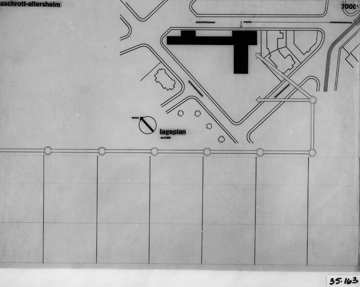
This image appears to be a photograph of a schematic or architectural drawing, possibly of a site plan or a layout for a building complex. The drawing is in black and white and includes labeled elements, with lines demarcating different areas and paths, suggesting roads or walkways. Some text on the drawing is visible, such as "aschrott-altersheim" and "lageplan," which is German for "site plan." There's also a scale indicator in the lower left corner specifying a 1:1000 ratio, and a compass direction marked with "N" for North. The image includes numbers like "7000x" that likely correspond to measurements, as well as various geometric shapes and patterns indicating the structure and design elements of the plan. The photograph includes the border of the drawing, showing the edges of the paper, and it's surrounded by a black frame. There is a number "55.1623" in the bottom right corner, which might be a reference number or identifier for the drawing.
Created by gpt-4o-2024-05-13 on 2025-03-06
This is an image of an architectural site plan or layout titled "aschrott-altersheim". The plan appears to display the layout of a site with different infrastructural markings and plot divisions.
The upper portion of the plan shows various roadway layouts and a building structure in black fill. The structure could possibly represent the main building or an important facility within the site. The schematic includes roadways, pathways, and other plotted areas.
The lower part contains geometric divisions which could represent plot sections or different zones within the site. There are also several circular symbols or markers along a straight line near the bottom, which might indicate significant points or features in the layout.
The term "lageplan" with a scale notation of 1:1000 can be found in the middle of the layout, indicating that this is indeed a plan of the location with a specified scale for measurement. The reference number "55.163" is written at the bottom right corner.
Anthropic Claude
Created by claude-3-haiku-20240307 on 2025-01-14
The image appears to be a diagram or site plan of a location called "Aschrott-Altersheim". The plan contains various geometric shapes, lines, and labels that suggest it is a technical drawing or architectural blueprint. There are no human figures or identifying details visible in the image.
Created by claude-3-5-sonnet-20241022 on 2025-01-14
This image appears to be an architectural site plan or layout drawing labeled "aschrott-altersheim" with "lageplan" (German for "site plan") written on it. The drawing shows a T-shaped building structure in black, surrounded by roads or pathways indicated by simple lines. The bottom portion of the image contains a grid or series of rectangular divisions. The drawing is quite minimalist and appears to be a technical document, possibly from an architectural or urban planning context. It's presented in black and white, with a dark border around the edges, suggesting this might be a photographed or scanned copy of an original document.
Created by claude-3-opus-20240229 on 2025-01-14
The image shows an architectural plan or blueprint for a building or structure called "aschrott-altensheim". The plan depicts the layout and floor plan of what appears to be some kind of facility, potentially a residential or care facility based on the name. The plan includes markings and labels indicating different rooms, corridors, and features of the building design. The plan is drawn in black ink on a light gray background and framed by a black border.
Created by us.anthropic.claude-3-5-sonnet-20241022-v2:0 on 2025-06-26
This appears to be an architectural site plan or layout drawing. At the top of the image, there's text that reads "aschrott-altersheim" and the drawing shows various geometric shapes, pathways, and building outlines. There's also text that reads "lageplan" which is German for "site plan" or "layout plan." The drawing is in black and white and appears to be quite minimalist in style, with clean lines and simple shapes. The layout includes what appears to be a T-shaped structure in the upper right corner, and several circular elements and connecting pathways throughout the design. The bottom portion of the plan shows a grid-like pattern divided into equal sections.
Meta Llama
Created by us.meta.llama3-2-90b-instruct-v1:0 on 2025-01-14
The image presents a black-and-white architectural plan, likely for a building or structure, with a focus on its layout and design. The plan is set against a white background, surrounded by a thick black border that adds depth and contrast to the overall visual.
Key Features:
- Title: "aschrott-altersheim" is written in the top-left corner, suggesting that this plan may be related to a specific project or location.
- Scale: A scale is provided in the bottom-right corner, indicating that the plan is drawn to a specific scale, which is essential for accurate measurement and interpretation.
- Labels: Various labels are scattered throughout the plan, including "lageplan" (site plan) and "7000," which may refer to a specific room or area within the building.
- Lines and Symbols: The plan features a range of lines, symbols, and shapes that represent different elements of the building's design, such as walls, doors, windows, and corridors.
- Border: The thick black border surrounding the plan adds a sense of professionalism and attention to detail, suggesting that this is a formal architectural document.
Overall Impression:
The image appears to be a detailed and technical architectural plan, likely created by a professional architect or designer. The use of a scale, labels, and various symbols suggests that this plan is intended for use in the construction or renovation of a building, and the attention to detail and professionalism evident in the design suggest that it is a high-quality document.
Created by us.meta.llama3-2-11b-instruct-v1:0 on 2025-01-14
The image is a black and white architectural plan, likely for a building or development project. It appears to be a blueprint or technical drawing, featuring various symbols, lines, and text that convey information about the design.
Key Features:
- Title: The top-left corner of the image displays the title "aschroft-altersheim" in bold, black font.
- Plan Layout: The main body of the image shows a detailed plan layout, including roads, buildings, and other structures. The plan is divided into sections, with each section labeled with a unique identifier.
- Symbols and Text: Throughout the plan, various symbols and text are used to convey information about the design. These include arrows, lines, and abbreviations that likely represent different features or elements of the project.
- Scale: In the top-right corner, the scale of the plan is indicated, showing a ratio of 1:1000.
- Date: In the bottom-right corner, the date "35.163" is handwritten in black ink, suggesting that this is an older document.
Overall Impression:
The image appears to be a technical drawing or blueprint, created for a specific purpose such as construction or urban planning. The level of detail and the use of specialized symbols and text suggest that it was created by a professional architect or engineer. The presence of a date and scale further supports this interpretation.
Amazon Nova
Created by amazon.nova-pro-v1:0 on 2025-01-14
The image shows a drawing of a floor plan of a building, possibly a factory or a warehouse. The drawing is on a piece of paper with a black border, and it is placed on a surface, possibly a table. The drawing is divided into sections, with each section labeled with a number. The drawing also includes a scale and a legend, which indicates the different types of rooms or areas in the building.
Created by amazon.nova-lite-v1:0 on 2025-01-14
The image shows a black-and-white map of the town of Aschrott-Altersheim. The map is framed in black and has a grid pattern with numbers and letters. The map includes a legend in the top left corner, which indicates the different types of buildings and structures in the town. The map also includes a scale bar in the bottom right corner, which shows the distance between different parts of the town. The map appears to be an old-fashioned, hand-drawn map, with a slightly faded appearance.
Created by amazon.nova-pro-v1:0 on 2025-01-12
The image is a black-and-white photograph of a detailed architectural plan, likely from a construction project. The plan is enclosed in a frame with a black border. The plan itself is a large-scale drawing that includes various elements such as buildings, roads, and other structures. The drawing is labeled with different sections and measurements, indicating the scale and dimensions of the project. The photograph appears to be a close-up of the plan, focusing on a specific area.
Created by amazon.nova-lite-v1:0 on 2025-01-12
The image shows a black-and-white architectural plan or blueprint of a building or structure. The plan appears to be a floor plan or layout, with various lines, shapes, and labels indicating different areas, rooms, and features of the building. The plan is divided into sections, with labels such as "Aschrott-Altersheim" and "Lageplan" indicating the name of the building and the location plan, respectively. The plan also includes measurements and dimensions, as well as various symbols and notations that are commonly used in architectural plans.
Google Gemini
Created by gemini-2.0-flash-lite on 2025-05-17
Here's a description of the image:
Overall:
The image is a black and white architectural plan, possibly a site plan or layout diagram. It's mounted in a frame, with a dark black border, and appears to be a photograph of the plan.
Details:
- Plan: The main subject is the plan itself. It features thin black lines on a light-colored background, likely paper. The plan includes:
- Roads and pathways
- Buildings and structures
- Text elements, including the name "aschrott-altersheim" and "lageplan". There are also scales indicated.
- A compass rose (the circular symbol indicating direction)
- What could be a parking area (the long rectangles at the bottom of the plan)
- Frame: The plan is within a white border and is mounted in a black frame.
- Appearance: The image has a slightly aged or archival feel due to the black and white tones and likely, the method of preservation.
- Number: The plan has a number in the bottom right corner, 35-163
Overall Impression:
The photograph is of an architectural or engineering document, likely used for planning or design purposes.
Created by gemini-2.0-flash on 2025-05-17
The image shows a black and white photo of an architectural plan. The plan, labeled "aschrott-altersheim" and "lageplan," features a grid of rectangular plots at the bottom, likely representing building sites. Above this, a network of roads and structures is outlined, including what appears to be a large building shaped like a "T." A compass rose is positioned above the grid, indicating direction. The plan is framed by a dark border, and a number "35-163" is visible in the lower right corner. The photograph appears to be of a physical document, with the edges of the paper visible.
Mistral Pixtral
Created by us.mistral.pixtral-large-2502-v1:0 on 2025-06-03
The image depicts a detailed site plan or map, likely for a construction or development project. Here are the key elements observed in the image:
Title and Labels:
- The map is labeled "Lageplan" which translates to "site plan" in English.
- There is another label "aschrott-altersheim" which could refer to a specific location or facility, possibly a retirement home named Aschrott.
Scale:
- The scale of the map is indicated as "1:7000," meaning that 1 unit on the map represents 7000 units in reality.
Layout:
- The map shows various roads, paths, and possibly railway tracks or utility lines.
- There are several intersecting lines and curves, indicating the layout of the roads and paths within the site.
- Some areas are shaded or filled in black, which might represent buildings, structures, or significant landmarks.
Grid:
- At the bottom of the map, there is a grid with several vertical lines and circles, which might be used for reference or alignment purposes.
Additional Markings:
- There are some circular and oval shapes, which could represent specific features or installations within the site.
- The map appears to be mounted or framed, suggesting it might be part of a presentation or display.
Overall, the image provides a detailed overview of a specific site, likely for planning or development purposes, with clear indications of roads, structures, and other significant features.
Qwen
No captions written
Text analysis
Amazon