Machine Generated Data
Tags
Color Analysis
Feature analysis
Amazon
Clarifai

Clarifai
| Picture frame | 98% | |
Categories
Imagga
created on 2022-06-04
| paintings art | 66.6% | |
| streetview architecture | 17.3% | |
| text visuals | 15.2% | |
Captions
Microsoft
created by unknown on 2022-06-04
| a clock on the wall | 40.6% | |
| a close up of a monitor | 40.5% | |
| a close up of a clock | 40.4% | |
Clarifai
No captions written
Salesforce
Created by general-english-image-caption-blip on 2025-05-21
a photograph of a map of hasselberg hassele hassele hassele has
Created by general-english-image-caption-blip-2 on 2025-06-28
a map of the city of haeselhof, with a black and white photo of the
OpenAI GPT
Created by gpt-4 on 2024-12-07
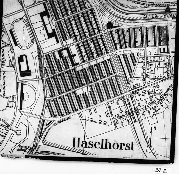
The image shows a framed black-and-white map or plan, with the title "Haselhorst" indicating that it is a representation of a specific area by that name. The map is detailed with various lines representing roads or paths, and some structures are marked. The map lines are densest in the central and right portions, suggesting a more developed or planned area, whereas the left side has more open and less densely marked regions. The body of water on the left side is bordered by a developed waterfront, indicated by the solid dark shapes representing buildings or other facilities. The map also includes labels such as "Pumpstation" (pump station) hinting at some infrastructure elements. At the bottom right, there is a number "37.2", likely a reference mark or cataloging number for the map in a collection or series. The map appears to be somewhat damaged or worn at its bottom-left corner, revealing the white matting beneath.
The physical conditions indicate the image may be archival or of historical significance. The identifying feature "Haselhorst" could be referring to an area within a city or a region that is named accordingly, possibly within a German-speaking context as the names and terms on the map suggest German language use.
Created by gpt-4o-2024-05-13 on 2024-12-07
The image depicts an old map of a section of Haselhorst, which is a locality in Berlin, Germany. The map is detailed, showing street layouts, buildings, and other structures. Key features include a "Pumpsstation" (pump station) and an area labeled "Ehemalige Pulverfabrik" (former powder factory). Rail lines and tracks are also visible, as well as planned roads labeled "Geplante Straßenneu.a.Stichstr." (planned road extension and spur). The map is black and white, and it appears to be framed or placed on a backing, possibly for preservation or display. There is a handwritten label "37.2" at the bottom.
Anthropic Claude
Created by us.anthropic.claude-3-5-sonnet-20241022-v2:0 on 2025-06-24
This image appears to be a black and white map or city plan of Haselhorst, which seems to be a district or area. The map shows various streets, buildings, and infrastructure layouts in a detailed aerial view. There are parallel lines that could represent railway tracks or similar transportation infrastructure, and various blocks and structures are clearly marked. The map includes what appears to be a pumping station marked on it, and the overall layout suggests this is an industrial or mixed-use area. The map has a clear title "Haselhorst" at the bottom and appears to be a historical or archival document based on its style and presentation.
Created by claude-3-haiku-20240307 on 2024-12-07
This image appears to be a map of the Haselhorst area, showing the layout of the buildings, streets, and other infrastructure in the area. The map uses a black and white, schematic style to depict the details of the neighborhood, with clearly defined blocks, roads, and other landmarks. The map includes labels such as "Haselhorst" to identify the specific location shown.
Created by claude-3-5-sonnet-20241022 on 2024-12-07
This appears to be a black and white map or city plan of Haselhorst, which shows a detailed layout of streets and buildings. The map includes what looks like residential blocks arranged in a grid pattern, with some larger facilities or structures visible, including what appears to be a pump station noted in one corner. There are curved roads or pathways, and the area seems to be divided into distinct sections. The image has a border and appears to be a historical or archival document, with "37.2" marked at the bottom. The text "Alter Berg" can be seen in the upper portion of the map, and the overall layout suggests this is likely a German urban planning document or municipal map.
Meta Llama
Created by us.meta.llama3-2-11b-instruct-v1:0 on 2024-12-07
The image depicts a map of the Haselhorst neighborhood in Berlin, Germany. The map is presented in black and white and features a detailed layout of the area's streets, buildings, and other notable landmarks.
- Map Layout:
- The map is rectangular in shape, with a black border surrounding it.
- The map is divided into sections, each representing a different area of the neighborhood.
- The streets are labeled with their names, and the buildings are represented by small rectangles or squares.
- There are several parks and green spaces throughout the neighborhood, which are depicted as larger rectangles or squares.
- Notable Landmarks:
- The map highlights several notable landmarks in the neighborhood, including the "Pumpstation" (water pumping station), the "Kreisverkehr" (roundabout), and the "Alter Berlin" (old Berlin) area.
- There are also several other buildings and structures marked on the map, including schools, churches, and commercial buildings.
- Additional Features:
- The map includes several additional features, such as the location of public transportation routes (e.g., buses, trains) and the boundaries of the neighborhood.
- There are also several symbols and abbreviations used on the map to represent different types of buildings or features (e.g., "B" for building, "P" for park).
Overall, the map provides a detailed and informative view of the Haselhorst neighborhood in Berlin, highlighting its layout, notable landmarks, and additional features.
Created by us.meta.llama3-2-90b-instruct-v1:0 on 2024-12-07
The image is a black-and-white map of the Haselhorst neighborhood in Berlin, Germany. The map appears to be a historical document, possibly from the early 20th century, and features a detailed layout of streets, buildings, and other geographical features.
Key Features:
- Map Orientation: The map is oriented with north at the top, as indicated by the "N" symbol in the bottom-right corner.
- Street Names: Several street names are visible on the map, including "Alter Berliner Strasse" and "Pulverfabrik."
- Building Layout: The map shows a mix of residential and industrial buildings, with some areas appearing more densely populated than others.
- Geographical Features: The map includes several geographical features, such as the "Spree" river, which runs along the eastern edge of the neighborhood.
- Scale: The map does not include a scale, making it difficult to determine the exact size of the area depicted.
- Date: The map is undated, but based on the style and content, it is likely from the early 20th century.
- Condition: The map appears to be in good condition, with some minor tears and creases visible along the edges.
Conclusion:
Overall, the image provides a valuable glimpse into the history of the Haselhorst neighborhood in Berlin, Germany. The detailed map offers insights into the layout and development of the area during the early 20th century, and could be useful for researchers or historians studying the region.
Amazon Nova
Created by amazon.nova-lite-v1:0 on 2025-02-27
The image shows a black-and-white map of a town called Haselhorst. The map is framed in a black border and has a white background. The map shows the layout of the town, including streets, buildings, and other landmarks. The map is labeled with the name "Haselhorst" in the center, and there are some numbers and letters in the corners of the map. The map appears to be an old map, possibly from the early 20th century.
Created by amazon.nova-pro-v1:0 on 2025-02-27
The image shows a black-and-white map of a place called "Haselhorst," which is written in bold letters at the bottom of the map. The map is enclosed in a black border, and the words "37-2" are written on the bottom right corner of the map. The map depicts the layout of the area, including buildings, roads, and other structures. The buildings are arranged in a grid-like pattern, and the roads are marked with lines.
Google Gemini
Created by gemini-2.0-flash-lite on 2025-04-28
Here's a description of the image:
Overall Impression:
The image is a black and white photograph of a map or architectural plan. It is mounted within a black border and framed by a wider, white background.
Content and Details:
- Map/Plan: The central element is a detailed rendering of a place called "Haselhorst". It features a grid-like layout of streets and buildings, indicative of urban planning.
- Urban Features: There are indicators on the map which indicate that it is showing a combination of residential and industrial areas. It shows a sports field and what appears to be a former "Pulverfabrik" or powder factory
- Labeling: Numerous words and labels are present, all in German, indicating the location, geographical features, and perhaps planned expansions. Key mentions include "Haselhorst," "Alter Berlin," and "Pump station."
- Orientation: A directional arrow pointing to the North (N) is present.
- Technical Details: The lower right corner includes the number "37.2," likely a reference or index number for the original document.
Style and Context:
- The image has a vintage aesthetic due to the monochromatic nature and the slightly aged look of the paper. It suggests historical, possibly architectural or urban planning, documentation.
Overall, the image provides a glimpse of an old map, offering insight into urban planning and the geographical elements of a specific area called Haselhorst in Berlin.
Created by gemini-2.0-flash on 2025-04-28
Here's a description of the image:
The image is a black and white photograph of a map of "Haselhorst". It's framed with a black border that has a white border beneath it.
The map itself appears to be a detailed layout of a neighborhood or town. Prominently labeled is "Haselhorst" in a bold typeface. Key features visible on the map include:
- A large rectangular area filled with rows of long, narrow buildings, likely representing housing or industrial buildings.
- A section labeled "Ehemalige Pulverfabrik" which translates to "former gunpowder factory" suggesting the area may have historical significance.
- Other buildings, streets, and a railway line are depicted in detail.
- A curved line labeled "Straßebahn" suggests a tram or streetcar line.
- A compass rose (N) indicating north.
- Areas marked for "ALTER BERL" and "Geplante Verlängerung d. Stick"
The map has a vintage or historical appearance. The text and linework are clear, indicating it was likely a printed map rather than hand-drawn.
There's also a handwritten or printed number "37.2" on the map close to the bottom right.
Mistral Pixtral
Created by us.mistral.pixtral-large-2502-v1:0 on 2025-04-28
The image is a black and white map of Haselhorst, a locality in Berlin, Germany. The map appears to be a detailed plan, likely from a historical period, showing the layout of streets, buildings, and other features in the area.
Key features of the map include:
- Street Layout: The map shows a grid-like arrangement of streets, with many parallel and perpendicular roads intersecting each other.
- Buildings: There are numerous rectangular shapes representing buildings, indicating a densely built-up area.
- Railway Lines: There are several railway tracks depicted, suggesting the presence of a significant railway infrastructure in the area.
- Landmarks: Specific landmarks and facilities are labeled, such as "Pumpstation," "Brennstofflager" (fuel storage), and "Gärtnerei" (garden center or nursery).
- Directional Indicator: There is a compass rose indicating the north direction, which helps in understanding the orientation of the map.
- Labels: The map is labeled with the name "Haselhorst" prominently displayed, and there are additional labels for various streets and locations.
- Scale and Reference: The map includes a reference number "37-2" in the bottom right corner, which might be useful for archival or reference purposes.
Overall, the map provides a detailed view of the urban layout of Haselhorst, highlighting its infrastructure, key facilities, and street network.
Qwen
No captions written
Text analysis
Amazon