Human Generated Data

Title

Recreation and Cultural Buildings, Berlin-Tiergarten, 1929-1930: Map of Berlin indicating development of Jägerstrasse, 1:1000

Date

1929-1930

People

Artist: Walter Gropius, German 1883 - 1969

Classification

Prints

Credit Line

Harvard Art Museums/Busch-Reisinger Museum, Gift of Walter Gropius, BRGA.43.7

Human Generated Data

Title

Recreation and Cultural Buildings, Berlin-Tiergarten, 1929-1930: Map of Berlin indicating development of Jägerstrasse, 1:1000

People

Artist: Walter Gropius, German 1883 - 1969

Date

1929-1930

Classification

Prints

Credit Line

Harvard Art Museums/Busch-Reisinger Museum, Gift of Walter Gropius, BRGA.43.7

Machine Generated Data

Tags

Amazon
created on 2022-06-04

Plan 99.5
Plot 99.5
Diagram 99.5
Electronics 95.6
Screen 95.6
Display 95.6
Transportation 89.4
Vehicle 89.4
Aircraft 89.4

Clarifai
created on 2023-10-31

no person 98.8
desktop 95.4
retro 93.3
art 91
chalk out 90.4
modern 90.1
illustration 90.1
paper 90
design 89.4
abstract 89.3
technology 88.4
architecture 87.5
screen 87.1
business 86.8
old 86.6
graphic design 84.9
science 84.6
antique 83.3
blank 82.8
scraping 82.5

Imagga
created on 2022-06-04

paper 38.4
drawing 28.1
office 28.1
plan 27.4
business 26.7
construction 24
architect 23.2
structure 23.1
architecture 22
design 21.9
blueprint 21.5
billboard 21
pen 21
work 19.6
money 19.6
project 19.2
house 19.2
financial 17.8
sketch 17.8
diagram 17.3
signboard 17
finance 16.9
drafting 16.7
investment 16.5
engineering 16.2
building 16.2
home 15.9
pencil 15.8
binding 15.4
contractor 14.6
designer 14.5
mousetrap 14
device 13.9
blueprints 13.8
plans 13.8
print 13.2
trap 12.8
engineer 12.5
tools 12.3
computer 12.3
stock 12.2
document 12.1
slide rule 12
grunge 11.9
old 11.8
equipment 11.8
earnings 11.7
builder 11.6
architectural 11.5
blank 11.1
note 11
data 11
measurements 10.9
draft 10.8
currency 10.8
graph 10.6
chart 10.5
draw 10.5
freight car 10.4
book 10.2
black 10.2
scale 10.2
economy 10.2
antique 9.9
idea 9.8
market 9.8
information 9.7
paperwork 9.7
accounting 9.7
analog computer 9.6
car 9.6
empty 9.4
card 9.4
floor 9.3
message 9.1
notebook 9
table 8.9
desk 8.9
metal 8.8
graphic 8.8
mechanical 8.7
report 8.7
technical 8.7
planning 8.7
close 8.6
bill 8.6
development 8.6
balance 8.5
frame 8.4
color 8.3
box 8.3
dirty 8.1
new 8.1
wealth 8.1
ruler 7.8
container 7.8
finances 7.7
texture 7.6
exchange 7.6
build 7.6
vintage 7.4
glasses 7.4
retro 7.4
banking 7.4
object 7.3
bank 7.3
industrial 7.3
success 7.2
wheeled vehicle 7.2
job 7.1
working 7.1
growth 7
modern 7
calculator 7

Google
created on 2022-06-04

Rectangle 89.4
Triangle 80.9
Font 78.9
Parallel 78.5
Engineering 72.5
Technical drawing 66
Pattern 66
Schematic 63.6
Diagram 63.1
Plan 61.2
Map 59.2
Drawing 58.5
Slope 56.6
Artwork 55.3
Line art 53.6
Monochrome photography 51
Symmetry 50.3

Microsoft
created on 2022-06-04

drawing 97.7
sketch 97.4
text 87.3
black and white 78.3
monochrome 67.5
picture frame 58.1
gallery 52.2
map 50.8

Color Analysis

Feature analysis

Amazon

Monitor
Airplane

Clarifai

Picture frame

AWS Rekognition

Monitor 95.6%

AWS Rekognition

Airplane 89.4%

Clarifai

Picture frame 99.6%

Categories

Imagga
created on 2022-06-04

cars vehicles 79%
text visuals 19.9%

Captions

Microsoft
created by unknown on 2022-06-04

a screen shot of a window 49%
a close up of a window 48.9%
a close up of a screen 48.8%

Salesforce

Created by general-english-image-caption-blip on 2025-05-21

a photograph of a map of a city with a map of the area

Created by general-english-image-caption-blip-2 on 2025-07-02

a black and white photograph of a plan of a city

OpenAI GPT

Created by gpt-4 on 2024-12-07

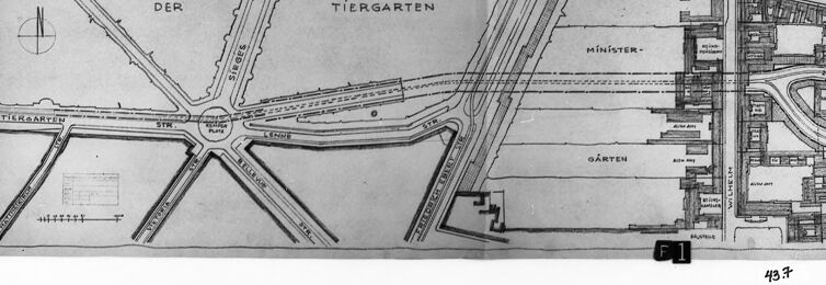
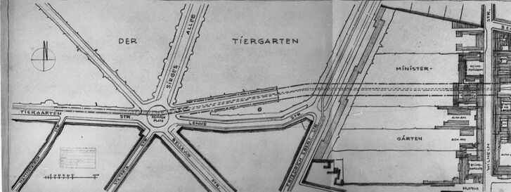
The image appears to be a black and white photograph of a framed, historic city plan or architectural drawing. The plan shows a layout of streets, with a large roundabout or star-shaped intersection at the center marked "TIERGARTEN" which suggests a location in German-speaking areas, specifically related to an area named 'Tiergarten.' From the central roundabout, multiple streets radiate outwards.

In the upper left corner of the map, there's a compass rose indicating the North direction. The map details have certain words in German, such as "STR" which could be abbreviated for "Straße" meaning "street" in German. To the right, there is a more densely plotted area with labeled blocks, possibly indicating buildings, and the word "Gärten” which translates to "gardens" suggesting there might be garden plots in this part of the plan.

The detail and style of the drawing indicate that it may be a historical document or plan, possibly related to urban development or the layout of a specific part of a city. The bottom right corner has a label, "F1," and the number "43" is also visible, which might pertain to cataloging or reference within a collection or an archive. The image overall has a slightly faded and aged look, and there is a white border surrounding the plan within the frame, hinting at the age of the document.

Created by gpt-4o-2024-05-13 on 2024-12-07

The image is a black-and-white photograph of a map framed under glass. The map appears to depict a section of a city, with streets and notable areas labeled. Key elements observed on the map include:

  • An area marked as "Der Tiergarten," which indicates a park or garden.
  • Several streets converging at a central point, including streets labeled "Straße unser," "Ostender Allee," "Hauptallee," "Tiergartenstr," and others.
  • Areas labeled "Ministergärten" and other related labels, likely denoting office buildings or ministerial gardens.
  • Buildings and neighborhoods with detailed layouts, showing various structures and their arrangement.
  • A compass rose indicating orientation.
  • A scale for distance measurement.
  • The numbers "43.8" can be seen written in the lower right corner, possibly an identifier for the map or the document archive reference.

The map is carefully presented within the frame, suggesting its importance or value for historical, planning, or administrative purposes.

Anthropic Claude

Created by us.anthropic.claude-3-5-sonnet-20241022-v2:0 on 2025-06-25

This image appears to be an architectural or city planning map/drawing showing part of Berlin's Tiergarten area. It's a black and white technical drawing that shows various streets, pathways, and buildings in what seems to be a section of the city. The word "TIERGARTEN" is clearly visible in the upper right portion of the map, and there are various other German labels and street layouts shown. The drawing appears to be historical in nature, possibly from architectural or urban planning documents. The image has a dark border or frame around it, suggesting it might be a photograph or scan of an original document.

Created by claude-3-haiku-20240307 on 2024-12-07

The image appears to be a black and white architectural sketch or plan, possibly of a city or urban area. It shows a complex layout with various roads, buildings, and labeled features such as "Der Tiergarten" and "Minister-". The image has a grid-like structure and various lines and shapes representing different elements of the architectural or urban design. Without being able to identify any individuals, the image seems to depict an intricate engineering or planning document related to the layout and development of a city or urban environment.

Created by claude-3-5-sonnet-20241022 on 2024-12-07

This is a black and white architectural or city planning map showing "Der Tiergarten" area, which appears to be in Berlin. The map shows various streets and pathways intersecting in a star-like pattern, typical of European urban planning. On the right side of the map, there appears to be more detailed building layouts and what's labeled as "Minister-garten" (Minister's Garden). The map has a scale indicator and appears to be a historical document or planning drawing, presented in a frame or border. The overall layout shows careful urban planning with radiating boulevards characteristic of formal European city design.

Meta Llama

Created by us.meta.llama3-2-11b-instruct-v1:0 on 2024-12-07

The image depicts a black-and-white map of a city or town, with a focus on its layout and infrastructure. The map is presented in a black frame, set against a white background.

Map Details:

  • The map features a mix of roads, buildings, and other structures.
  • It includes several labels, such as "TIERGARTEN" and "MINISTER-," which suggest that the map may be related to a government or administrative area.
  • The map also appears to show a park or garden, as indicated by the label "GARTEN."
  • There are several other labels and markings on the map, but they are not easily decipherable.

Background:

  • The map is set against a white background, which provides a clean and neutral contrast to the black frame.
  • The background is plain and unadorned, allowing the viewer to focus on the map itself.

Overall:

  • The image presents a detailed and informative map of a city or town, with a focus on its layout and infrastructure.
  • The use of a black frame and white background creates a clean and professional appearance, making the image suitable for use in a variety of contexts, such as educational or historical research.

Created by us.meta.llama3-2-90b-instruct-v1:0 on 2024-12-07

The image depicts a map of an area, with the title "TIERGARTEN" prominently displayed. The map is divided into two sections: the left side features a detailed illustration of roads and buildings, while the right side appears to be a continuation of the same area, albeit with less detail.

Key Features:

  • Title: "TIERGARTEN" is written in bold letters at the top of the map.
  • Roads and Buildings: The left side of the map showcases a network of roads and buildings, including what appears to be a park or garden.
  • Continuation: The right side of the map seems to be a continuation of the same area, but with less detail.
  • Border: The map is surrounded by a thick black border, which adds a sense of depth and dimensionality to the image.
  • Background: The background of the image is a light gray color, which provides a subtle contrast to the darker tones of the map.

Overall Impression:

The image presents a clear and concise visual representation of the TIERGARTEN area, highlighting its key features and layout. The use of a bold title and a detailed illustration of roads and buildings creates a sense of clarity and precision, making it easy for viewers to understand the layout of the area.

Amazon Nova

Created by amazon.nova-lite-v1:0 on 2025-02-25

The image appears to be a black-and-white map or diagram of a city or town. The map is divided into sections with labels such as "Der," "Tiergarten," "Münster," "Garten," and "F1." The map also includes a compass rose in the top left corner, indicating the orientation of the map. The map is framed in a black border, and there is a number "43.7" in the bottom right corner. The image is somewhat blurry, making it difficult to read the labels and details on the map.

Created by amazon.nova-pro-v1:0 on 2025-02-25

The image is a black-and-white drawing of a city plan, likely from the early 20th century. The drawing is framed by a black border, giving it a vintage appearance. The plan depicts a section of a city with various buildings, roads, and other urban elements. The drawing is divided into several sections, each labeled with a different name, such as "Der Tiergarten" and "Minister-Garten." The buildings are depicted in a simplified manner, with rectangular shapes and windows. The roads are shown as lines connecting the buildings, and there are also some trees and other vegetation depicted in the drawing. The overall impression is of a well-planned and organized urban space, with a mix of residential and commercial buildings.

Google Gemini

Created by gemini-2.0-flash-lite on 2025-04-28

Here's a description of the image:

The image is a black and white photograph of a map. The map is folded and mounted within a black frame. The map itself shows an urban layout with roads, buildings, and labeled areas.

Here are some key details:

  • Map Content: The map appears to depict a city plan, likely of an area called "Tiergarten" (likely a park or garden area) based on the prominent labeling. Streets, buildings, and green spaces are illustrated with fine lines. The map is labeled in German.
  • Layout: The map features a radial street design, with streets converging on a central point, possibly a roundabout or plaza.
  • Framing: The map is held within a thick black frame, which is placed against a light-colored background, which may be a matte.
  • Overall Impression: The image has a historical feel due to its black and white nature. It suggests an archival document or a vintage photograph of an urban plan.

Created by gemini-2.0-flash on 2025-04-28

The image shows a framed black and white photograph of a map. The map is partially folded and appears to be mounted within a black frame, over a white background that is larger than the map itself.

The map is a detailed urban plan, likely of a section of a city. It features streets, buildings, and green spaces. The map includes text labels written in what appears to be German. Notable terms like "Tiergarten," "Ministergarten," and street names like "Sieges Allee" are visible, indicating a potentially German-speaking locale. The layout suggests a structured urban environment with defined blocks and roads. The map also contains a scale, aiding in distance and size estimation.

The photograph is shot in a way that captures the texture and depth of the framed map, with the black frame providing a contrast to the lighter map and white background.

Mistral Pixtral

Created by us.mistral.pixtral-large-2502-v1:0 on 2025-04-28

The image appears to be a historical architectural or urban planning map, likely from the early to mid-20th century, based on the style and details. Here is a detailed summary:

  1. Layout and Design:

    • The map is framed and displayed on a wall.
    • It features a central circular area labeled "PLATZ," which seems to be a significant focal point, possibly a plaza or square.
    • Surrounding the central circle are several radiating streets and pathways, creating a star-like pattern.
    • The map includes various labeled sections and buildings, suggesting a detailed plan of a specific area.
  2. Key Labels and Sections:

    • Tiergarten: Located on the left side of the map, this likely refers to a large urban park.
    • Der Str.: This could be an abbreviation for a street name, possibly "Der Straße" in German.
    • Minister-Gärten: This section is labeled on the right side, indicating an area possibly related to governmental or ministerial gardens.
    • Lehrter Bahnhof: Located on the far right, this likely refers to a train station, specifically the Lehrter Station in Berlin.
    • Humboldthafen: This is labeled near the central area, suggesting a harbor or waterfront area named after Alexander von Humboldt.
  3. Additional Details:

    • The map includes various smaller buildings and structures, particularly on the right side near the "Lehrter Bahnhof."
    • There are intricate details of pathways, roads, and possibly railway lines, indicating a well-planned urban area.
    • The map has a scale and a compass rose, providing orientation and measurement references.
  4. Context:

    • Given the labels and the style, this map likely depicts a part of Berlin, Germany.
    • The presence of "Tiergarten" and "Lehrter Bahnhof" suggests it is a significant historical or urban planning document from that city.

Overall, the image is a detailed urban planning map, likely from Berlin, showcasing a central plaza with radiating streets and significant landmarks such as Tiergarten and Lehrter Bahnhof.

Qwen

Text analysis

Amazon

DER
43.7
F
F 1
1
ALLEE
TIERGARTEN
GARTEN
SIRGES
MiNiSTER-
Muthor
HAPPY
ENGLY

Google

TIERAARTEN ******* DER Me TIERGARTEN MINISTER. GARTEN int 43.7
TIERAARTEN
*******
DER
Me
TIERGARTEN
MINISTER
.
GARTEN
int
43.7