Machine Generated Data
Tags
Color Analysis
Feature analysis

Categories
Imagga
| text visuals | 69.4% | |
| cars vehicles | 22.5% | |
| interior objects | 6.4% | |
Captions
Microsoft
created on 2022-06-04
| a flat screen tv | 36.5% | |
Azure OpenAI
Created by gpt-4 on 2024-12-07
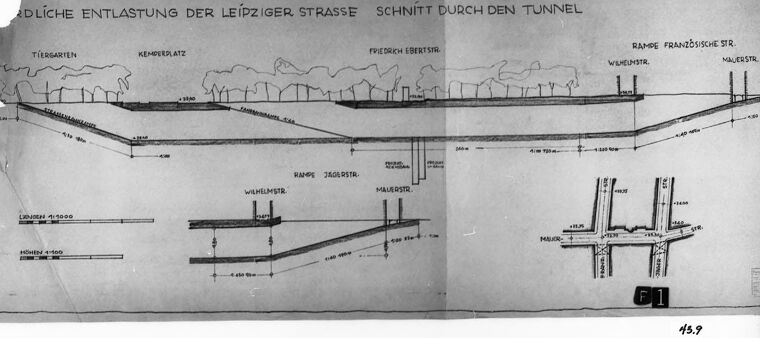
This image appears to be a photograph of a framed engineering drawing or blueprint. The content of the drawing looks like a cross-sectional diagram of a tunnel construction or infrastructure project. Specific elements include a tunnel beneath a street, labeled with various German words, suggesting a location in Germany or a German-speaking region. Words like "Tunnel," "Tiergarten," "Kemperplatz," "Friedrich-Ebertstr.," "Wilhelmstr.," "Ramp Französische Str.," and "Naurstr." can be seen which could be referencing streets, places, or aspects of the construction. There are also different scales or measurements noted on the drawing. The context seems to be explaining a traffic relief solution for "Leipziger Strasse" as indicated by the German phrase at the top, which roughly translates to "southern relief of Leipziger Strasse, cross-section through the tunnel." Below the main cross-section are detailed diagrams of intersections, perhaps showing entrance and exit ramps of the tunnel. The photograph itself is slightly damaged or worn on the left edge where the paper beneath the frame is exposed, but the drawing appears to be in good condition. The number "43" is visible at the bottom-right corner, possibly indicating this as part of a sequence or collection of drawings. There is also handwritten text "Fl 1" above a white strip labeled "45.9," which could correspond to some cataloging or filing system for the drawing.
Created by gpt-4o-2024-05-13 on 2024-12-07
The image appears to be a black and white photograph of an architectural or engineering drawing. The drawing is titled "Südliche Entlastung der Leipziger Strasse Schnitt durch den Tunnel," which translates from German to "Southern Relief of Leipziger Street Section through the Tunnel." The drawing includes a cross-sectional view of a planned or existing tunnel beneath the street, complete with labels and dimensions at various points. Notable areas in the drawing include "Tiergarten," "Kemmerplatz," "Friedrich Ebert Str.," and "Französische Str." The detailed sections illustrate different levels, ramps, and structural components of the tunnel, with labels for these various sections. There are also elevation profiles and vertical/horizontal measurements provided in the drawing, along with notes on construction or existing geographical features. The photograph of the drawing is presented within a frame, and there is some visible damage to the edges of the drawing, such as tears and missing paper. A label marked "F1" is visible on the drawing, and at the bottom right corner of the photograph, the number "45.9" is written. This image indicates detailed planning or documentation of urban infrastructure, likely for transportation purposes.
Anthropic Claude
Created by claude-3-haiku-20240307 on 2024-12-07
The image appears to be a technical diagram or blueprint showing the layout and cross-section of a tunnel. The diagram is labeled in German, indicating it is likely related to the construction or engineering of the Leipziger Strasse tunnel. The diagram provides detailed technical information about the dimensions, elevations, and structural elements of the tunnel design.
Created by claude-3-5-sonnet-20241022 on 2024-12-07
This is an architectural or engineering drawing showing a cross-section view of a tunnel project in Leipzig Street (Leipziger Strasse). The German text at the top reads "SCHNITT DURCH DEN TUNNEL" which translates to "Cross-section through the tunnel." The drawing shows different levels and sections of what appears to be an underground transport or infrastructure project. The drawing includes various landmarks and street names along the top, including "TIERGARTEN" and "FRIEDRICH EBERT STR." It features detailed technical measurements and structural elements, with multiple levels shown in cross-section view. The drawing appears to be a historical technical document, possibly from a city planning or infrastructure development project. The image is in black and white, and appears to be a photograph or reproduction of an original engineering document, mounted or framed with a dark border. There's a number "139" visible at the bottom right corner of the drawing.
Meta Llama
Created by us.meta.llama3-2-11b-instruct-v1:0 on 2024-12-07
The image presents a black-and-white diagram of a tunnel, showcasing its layout and various components. The diagram is divided into sections, each labeled with German text, providing a detailed overview of the tunnel's design. **Key Features:** * **Tunnel Layout:** The diagram illustrates the tunnel's path, including its length, width, and depth. * **Components:** Various components are depicted within the tunnel, such as: + **Tiersgarten:** A section of the tunnel is labeled "Tiersgarten," suggesting a connection to a nearby park or green space. + **Kemperplatz:** Another section is labeled "Kemperplatz," indicating a potential intersection or landmark within the tunnel. + **Friedrich Ebertstr.:** A section is labeled "Friedrich Ebertstr.," likely referencing a street or road that intersects with the tunnel. + **Ramses Französische Str.:** A section is labeled "Ramses Französische Str.," possibly indicating a connection to a foreign or international street or road. + **Wilmersdorfer Str.:** A section is labeled "Wilmersdorfer Str.," suggesting a connection to a street or road in the Wilmersdorf district. + **Maierstr.:** A section is labeled "Maierstr.," likely referencing a street or road in the Maier district. + **Lindenstr.:** A section is labeled "Lindenstr.," possibly indicating a connection to a street or road lined with linden trees. + **Monbijoustr.:** A section is labeled "Monbijoustr.," likely referencing a street or road in the Monbijou district. + **Bauhaus:** A section is labeled "Bauhaus," suggesting a connection to the famous Bauhaus art school or architecture movement. + **Kreuzung:** A section is labeled "Kreuzung," indicating a potential intersection or crossing point within the tunnel. + **Ramses:** A section is labeled "Ramses," possibly referencing the ancient Egyptian pharaoh Ramses II. + **Jägerstr.:** A section is labeled "Jägerstr.," likely referencing a street or road in the Jäger district. + **Wilhelmer.:** A section is labeled "Wilhelmer.," possibly indicating a connection to a street or road named after a German emperor or monarch. + **Maierstr.:** A section is labeled "Maierstr.," likely referencing a street or road in the Maier district. + **Lindenstr.:** A section is labeled "Lindenstr.," possibly indicating a connection to a street or road lined with linden trees. + **Monbijoustr.:** A section is labeled "Monbijoustr.," likely referencing a street or road in the Monbijou district. + **Bauhaus:** A section is labeled "Bauhaus," suggesting a connection to the famous Bauhaus art school or architecture movement. + **Kreuzung:** A section is labeled "Kreuzung," indicating a potential intersection or crossing point within the tunnel. + **Ramses:** A section is labeled "Ramses," possibly referencing the ancient Egyptian pharaoh Ramses II. + **Jägerstr.:** A section is labeled "Jägerstr.," likely referencing a street or road in the Jäger district. + **Wilhelmer.:** A section is labeled "Wilhelmer.," possibly indicating a connection to a street or road named after a German emperor or monarch. + **Maierstr.:** A section is labeled "Maierstr.," likely referencing a street or road in the Maier district. + **Lindenstr.:** A section is labeled "Lindenstr.," possibly indicating a connection to a street or road lined with linden trees. + **Monbijoustr.:** A section is labeled "Monbijoustr.," likely referencing a street or road in the Monbijou district. + **Bauhaus:** A section is labeled "Bauhaus," suggesting a connection to the famous Bauhaus art school or architecture movement. + **Kreuzung:** A section is labeled "Kreuzung," indicating a potential intersection or crossing point within the tunnel. + **Ramses:** A section is labeled "Ramses," possibly referencing the ancient Egyptian pharaoh Ramses II. + **Jägerstr.:** A section is labeled "Jägerstr.," likely referencing a street or road in the Jäger district. + **Wilhelmer.:** A section is labeled "Wilhelmer.," possibly indicating a connection to a street or road named after a German emperor or monarch. + **Maierstr.:** A section is labeled "Maierstr.," likely referencing a street or road in the Maier district. + **Lindenstr.:** A section is labeled "Lindenstr.," possibly indicating a connection to a street or road lined with linden trees. + **Monbijoustr.:** A section is labeled "Monbijoustr.," likely referencing a street or road in the Monbijou district. + **Bauhaus:** A section is labeled "Bauhaus," suggesting a connection to the famous Bauhaus art school or architecture movement. + **Kreuzung:** A section is labeled "Kreuzung," indicating a potential intersection or crossing point within the tunnel. + **Ramses:** A section is labeled "Ramses," possibly referencing the ancient Egyptian pharaoh Ramses II. + **Jägerstr.:** A section is labeled "Jägerstr.," likely referencing a street or road in the Jäger district. + **Wilhelmer.:** A section is labeled "Wilhelmer.," possibly indicating a connection to a street or road named after a German emperor or monarch. + **Maierstr.:** A section is labeled "Maierstr.," likely referencing a street or road in the Maier district. + **Lindenstr.:** A section is labeled "Lindenstr.," possibly indicating a connection to a street or road lined with linden trees. + **Monbijoustr.:** A section is labeled "Monbijoustr.," likely referencing a street or road in the Monbijou district. + **Bauhaus:** A section is labeled "Bauhaus," suggesting a connection to the famous Bauhaus art school or architecture movement. + **Kreuzung:** A section is labeled "Kreuzung," indicating a potential intersection or crossing point within the tunnel. + **Ramses:** A section is labeled "Ramses," possibly referencing the ancient Egyptian pharaoh Ramses II. + **Jägerstr.:** A section is labeled "Jägerstr.," likely referencing a street or road in the Jäger district. + **Wilhelmer.:** A section is labeled "Wilhelmer.," possibly indicating a connection to a street or road named after a German emperor or monarch. + **Maierstr.:** A section is labeled "Maierstr.," likely referencing a street or road in the Maier district. + **Lindenstr.:** A section is labeled "Lindenstr.," possibly indicating a connection to a street or road lined with linden trees. + **Monbijoustr.:** A section is labeled "Monbijoustr.," likely referencing a street or road in the Monbijou district. + **Bauhaus:** A section is labeled "Bauhaus," suggesting a connection to the famous Bauhaus art school or architecture movement. + **Kreuzung:** A section is labeled "Kreuzung," indicating a potential intersection or crossing point within the tunnel. + **Ramses:** A section is labeled "Ramses," possibly referencing the ancient Egyptian pharaoh Ramses II. + **Jägerstr.:** A section is labeled "Jägerstr.," likely referencing a street or road in the Jäger district. + **Wilhelmer.:** A section is labeled "Wilhelmer.," possibly indicating a connection to a street or road named after a German emperor or monarch. + **Maierstr.:** A section is labeled "Maierstr.," likely referencing a street or road in the Maier district. + **Lindenstr.:** A section is labeled "Lindenstr.," possibly indicating a connection to a street or road lined with linden trees. + **Monbijoustr.:** A section is labeled "Monbijoustr.," likely referencing a street or road in the Monbijou district. + **Bauhaus:** A section is labeled "Bauhaus," suggesting a connection to the famous Bauhaus art school or architecture movement. + **Kreuzung:** A section is labeled "Kreuzung," indicating a potential intersection or crossing point within the tunnel. + **Ramses:** A section is labeled "Ramses," possibly referencing the ancient Egyptian pharaoh Ramses II. + **Jägerstr.:** A section is labeled "Jägerstr.," likely referencing a street or road in the Jäger district. + **Wilhelmer.:** A section is labeled "Wilhelmer.," possibly indicating a connection to a street or road named after a German emperor or monarch. + **Maierstr.:** A section is labeled "Maierstr.," likely referencing a street or road in the Maier district. + **Lindenstr
Created by us.meta.llama3-2-90b-instruct-v1:0 on 2024-12-07
The image is a black and white photograph of a technical drawing, likely an architectural or engineering plan. The drawing appears to be a cross-section of a tunnel or underground structure, with various lines and symbols indicating different features such as walls, floors, and ceilings. The text on the drawing is in German, suggesting that it may be related to a project in Germany. The drawing is presented on a white background, surrounded by a black border. The overall appearance of the image suggests that it is a historical document, possibly from the early 20th century. The use of black and white photography and the style of the drawing are consistent with this time period. In terms of specific details, the drawing shows a tunnel or underground structure with a series of arches or vaults. The walls and floors of the tunnel are depicted as being made of concrete or masonry, with metal beams or supports visible in some areas. There are also several symbols and markings on the drawing that appear to indicate different features or components of the tunnel, such as ventilation shafts or electrical conduits. Overall, the image provides a detailed and technical view of a tunnel or underground structure, likely from a historical context. It is a valuable resource for anyone interested in architecture, engineering, or the history of construction projects.
Text analysis
Amazon