Machine Generated Data
Tags
Color Analysis
Feature analysis
Amazon
Clarifai
AWS Rekognition
| Monitor | 69.4% | |

Categories
Imagga
created on 2022-06-04
| cars vehicles | 99.5% | |
Captions
Clarifai
No captions written
Salesforce
Created by general-english-image-caption-blip on 2025-05-21
a photograph of a map of a plan of a plan of a plan of a plan of a
Created by general-english-image-caption-blip-2 on 2025-07-02
a black and white drawing of a plan of a city
OpenAI GPT
Created by gpt-4 on 2024-12-07
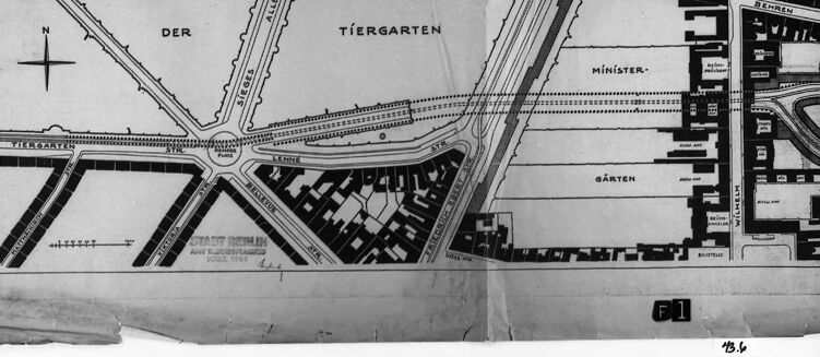
The image displays a black and white framed photograph or a reproduction of a city map or plan. The map is labeled in German, with words like "Der Tiergarten," indicative of a location in Germany, specifically referencing a park in Berlin. This name is associated with the central park in Berlin, which is known for its large green spaces, walkways, and historic significance.
The map shows a carefully laid out pattern of streets and plots, with some areas marked as "Gärten" (gardens), likely indicating green or open spaces. Even without specific knowledge of the map's date or the exact context, we can infer that it represents urban planning, possibly from the 19th or early 20th century, given the style of the map and the neatness of the urban grid.
The map itself is creased and shows signs of wear and tear, suggesting that it is an actual artifact and not merely a digital creation. Its physical condition further suggests it might be a historic piece. The displayed section is detailed, with a compass rose denoting north in the upper left corner, which is a typical feature in maps to orient the viewer.
Created by gpt-4o-2024-05-13 on 2024-12-07
The image depicts an old, framed map. The map appears to be a layout or section of a city, with distinct streets, buildings, and green areas marked.
Key details in the map include:
- A compass rose indicating the north direction.
- A section labeled "DER TIERGARTEN," which suggests this is a park or garden area within the city.
- Further sections labeled "MINISTER-GÄRTEN" and "HOFJÄGERALLEE."
- Several streets and structures are shown in black and white, with rectangular shapes indicating buildings and linear shapes indicating roads and pathways.
- The map is slightly worn and torn in places, particularly in the middle and lower regions, hinting at its age.
- There is a scale provided at the bottom left corner of the map for reference.
- The bottom right corner of the map contains the notation "F1" and a handwritten number "48.6."
Overall, the map appears to be a detailed, historical depiction of a specific section of a city, with focuses on important buildings and green spaces.
Anthropic Claude
Created by us.anthropic.claude-3-5-sonnet-20241022-v2:0 on 2025-06-25
This is a black and white architectural or city planning map showing part of the Tiergarten area in what appears to be Berlin. The map shows street layouts, building plots, and a prominent traffic circle or roundabout where several roads intersect. The text on the map is in German, with "DER TIERGARTEN" (The Tiergarten) clearly visible. The map appears to be a historical document, possibly a planning or survey drawing, mounted on a dark frame or border. There's a compass rose indicating north in the upper left corner, and the drawing shows various blocks, streets, and what appears to be garden or park areas ("GÄRTEN"). The image has some wear and tear visible, with some creases or damage to the paper.
Created by claude-3-haiku-20240307 on 2024-12-07
The image appears to be a black and white map or architectural plan. It shows a layout of a residential or urban area, with buildings, roads, and labeled sections such as "Der Tiergarten" and "Minister-Garten". The map has a grid-like structure with various geometric shapes and lines indicating different structures or zones within the planned area. The image does not contain any human faces or identifiable individuals.
Created by claude-3-5-sonnet-20241022 on 2024-12-07
This is a black and white architectural or city planning map showing a section of the Tiergarten area in Berlin. The map appears to be a street layout or urban planning document, with "DER TIERGARTEN" clearly labeled at the top. It shows various streets, intersections, and building blocks. There's a prominent roundabout or circular intersection visible in the center where several roads converge. The map includes a compass rose indicating north, and the detail level suggests this was likely used for urban development or planning purposes. The image is framed in what appears to be a dark border, and there seems to be some wear or aging visible on the document, suggesting it might be a historical planning document.
Meta Llama
Created by us.meta.llama3-2-11b-instruct-v1:0 on 2024-12-07
The image is a black and white photograph of a map, which appears to be a blueprint or architectural drawing. The map is displayed on a white surface, with a black frame around it.
The map is rectangular in shape and features a grid-like pattern with roads and buildings. There are several labels and markings on the map, including "DER" and "TIERGARTEN" in the top-left corner, and "MINISTER" and "GARTEN" in the bottom-right corner. The map also includes a compass rose in the top-left corner, indicating the direction of north.
The map appears to be hand-drawn and has some tears and creases, suggesting that it may be an old or worn-out document. The overall appearance of the map suggests that it may be a historical or vintage map, possibly from the early 20th century.
The background of the image is a plain gray color, which helps to highlight the details of the map. There are no other objects or features in the image, except for the map itself.
Overall, the image presents a clear and detailed view of the map, allowing the viewer to examine its features and markings closely.
Created by us.meta.llama3-2-90b-instruct-v1:0 on 2024-12-07
The image presents a black-and-white map of an area, likely a city or town, with various features and labels. The map is divided into sections, each with its own unique characteristics and markings.
Map Features:
- Roads: The map shows several roads, including a main road that runs through the center of the map and several smaller roads that branch off from it.
- Buildings: There are several buildings depicted on the map, including what appears to be a church or other religious structure.
- Parks: There is a large park or green space located in the top-left corner of the map.
- Waterways: There is a river or stream that runs along the bottom edge of the map.
Labels and Markings:
- Street Names: The map includes street names, such as "Tiergarten" and "Ministergarten."
- Building Labels: Some of the buildings on the map are labeled, including a "Minister" building and a "Garten" building.
- Other Markings: There are several other markings on the map, including what appears to be a compass rose in the top-left corner.
Overall:
- The map appears to be a historical document, possibly from the early 20th century.
- It provides a detailed view of the layout and features of the area, including roads, buildings, parks, and waterways.
- The map may have been used for planning or navigation purposes.
Amazon Nova
Created by amazon.nova-lite-v1:0 on 2025-02-27
A black-and-white image of a map of a city with a black border around it. The map is divided into sections with a white line separating them. The top section has the word "Tiergarten" written in it. The bottom section has the word "Garten" written in it. The map has a lot of text and numbers written on it. The map is placed on a white surface.
Created by amazon.nova-pro-v1:0 on 2025-02-27
The image is a black-and-white photograph of a piece of paper that is folded in half. The paper appears to be a map, with a grid-like structure that resembles a city plan. The map is divided into sections, with labels such as "Der Tiergarten" and "Minister" written on it. The paper is folded in a way that suggests it was meant to be used as a reference or guide.
Google Gemini
Created by gemini-2.0-flash-lite on 2025-04-28
Here's a description of the image:
The image is a black and white photograph of a map, framed and mounted under glass. The map appears to be a plan of a city area, likely Berlin, Germany, based on the German place names visible. The map is partially obscured by the frame and its paper is torn at the bottom.
Here's a breakdown of the details:
- Content: The map shows streets, buildings, and open spaces. The key labels that can be seen include "TIERGARTEN" (a park), "SIEGES ALLEE", "MINISTER-GARTEN," and street names like "BEHREN STR," "WILHELM STR."
- Orientation: The map is oriented with a compass rose, indicating north.
- Condition: The map is old and shows signs of wear, including tears. It is mounted in a simple frame.
- Context: The photograph's purpose is unclear. It could be a historical document, an architectural plan, or part of an archive.
- Presentation: The entire image is a black and white photograph of the map that is framed and protected.
Created by gemini-2.0-flash on 2025-04-28
Here is a description of the image:
The image is a black and white photograph of a framed map. The map appears to be folded or wrinkled in places. It shows a section of a city, likely Berlin based on the labels, with roads, buildings, and parks. The map includes the "Tiergarten," a well-known park in Berlin, and mentions "Minister-Garten." There are streets labeled, and the layout suggests an older, more planned city design. The frame is a simple dark color, and there is white space visible around the map within the frame, suggesting it's not perfectly aligned. The overall image has a documentary or archival feel. The map itself is detailed with streets, alleys, and building outlines clearly depicted. There are also markings such as a compass rose indicating directionality on the map.
Mistral Pixtral
Created by us.mistral.pixtral-large-2502-v1:0 on 2025-04-28
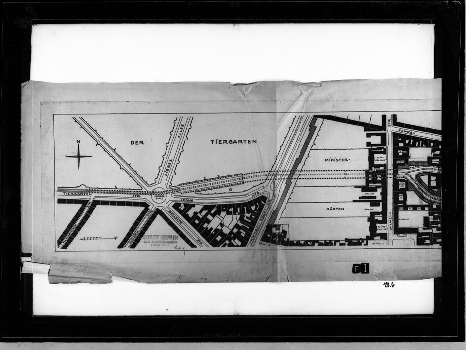
The image depicts a detailed black-and-white architectural plan or map, likely of a large urban or governmental complex. The plan includes several labeled sections and features:
- Tiergarten: This is a large park or garden area located in the central part of the map.
- Der Tiergarten: This label seems to refer to a specific section or entrance to the Tiergarten.
- Ministergärten: Located to the right of the Tiergarten, this appears to be a section designated for ministerial gardens.
- Kanzlergarten: This is situated to the left of the Tiergarten and seems to be a garden area designated for the chancellor.
- Reichskanzlei: Positioned below the Kanzlergarten, this is likely the Chancellery building.
- Neue Reichskanzlei: Located adjacent to the Reichskanzlei, this seems to be a new or additional Chancellery building.
- Führerbunker: This is situated below the Neue Reichskanzlei and is likely a fortified underground shelter.
- Adolf-Hitler-Platz: This is a plaza or square named after Adolf Hitler, located to the left of the Tiergarten.
- Krolloper: This is a building labeled to the left of the Adolf-Hitler-Platz, likely an opera house or theater.
- Potsdamer Platz: This is a significant public square or transportation hub located towards the bottom left of the map.
- Anhalter Bahnhof: This is a railway station located towards the bottom right of the map.
The map also includes various streets, pathways, and other buildings, indicating a well-planned urban layout. The orientation is marked with a compass in the top left corner, showing north. The plan appears to be part of a larger document or set of plans, as indicated by the numbering "B4" in the bottom right corner.
Qwen
No captions written
Text analysis
Amazon