Machine Generated Data
Tags
Color Analysis
Feature analysis
Amazon
Clarifai
AWS Rekognition
| Monitor | 82.8% | |

Categories
Imagga
created on 2022-06-04
| paintings art | 64.7% | |
| text visuals | 32.9% | |
| streetview architecture | 1.8% | |
Captions
Microsoft
created by unknown on 2022-06-04
| a screen shot of a computer monitor sitting on top of a desk | 29.8% | |
Clarifai
No captions written
Salesforce
Created by general-english-image-caption-blip on 2025-05-21
a photograph of a map of a map of a city
Created by general-english-image-caption-blip-2 on 2025-06-28
a black and white map of the city of paris
OpenAI GPT
Created by gpt-4 on 2024-12-07
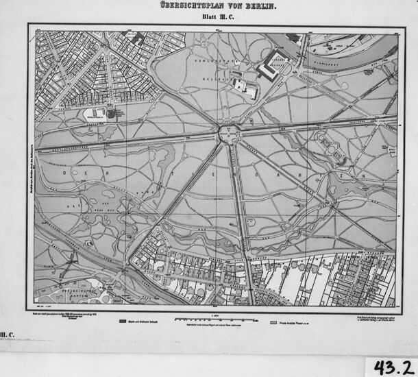
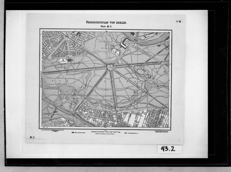
This image displays a black and white framed map. The text at the top of the map reads "Übersichtsplan von Berlin," which translates to "Overview map of Berlin." The map appears to be an older, historical document indicating it may showcase Berlin from a previous era. It's detailed with streets, blocks, possible rivers, and parks marked, and there are a few distinguishable features such as shaded areas and outlined structures that could represent significant buildings or public spaces.
Below the map, there are legends in German. On the bottom right of the map, the plate or section is identified as "Blatt III. C." implying that this is part of a series of maps or a larger atlas. There is a scale of meters provided for reference, indicating various distances. The photo number "43.2" is visible at the bottom right corner of the frame outside the map, likely referencing a cataloging or archival system. Overall, the image is a representation of urban planning and layout, crucial for historical and geographical studies of Berlin.
Created by gpt-4o-2024-05-13 on 2024-12-07
This image is a black-and-white map titled "Übersichtsplan von Berlin," which translates to "Overview Plan of Berlin." The map is labeled "Blatt II. C.," meaning "Sheet II. C." It depicts a detailed layout of a section of Berlin, showing streets, buildings, and park areas.
- The center of the map features a large circular intersection from which several main roads emanate like spokes on a wheel.
- Several smaller streets and buildings are shown in a grid-like pattern to the northwest and southeast.
- The map also includes park areas with pathways and possibly natural features like rivers or lakes.
- There are labels on the map indicating specific locations, and the map scale is noted at the bottom.
- It is framed within a black border, with the number "43.2" visible at the bottom right of the frame.
This map appears to be historical, offering insight into the geographic layout and urban planning of Berlin at the time it was created.
Anthropic Claude
Created by us.anthropic.claude-3-5-sonnet-20241022-v2:0 on 2025-06-24
This is a historical map titled "Übersichtsplan von Berlin" (Overview Plan of Berlin). It appears to be a black and white map showing a section of Berlin, likely from the 19th century. The map shows street layouts, buildings, and urban development patterns of a portion of the city. There are clear indications of built-up areas with detailed street grids as well as more open or undeveloped areas. The map includes what appears to be parks, waterways, and various urban features typical of city planning documents from that era. The image has a reference number "43.2" in the bottom right corner and appears to be a reproduction or archival copy of the original map.
Created by claude-3-haiku-20240307 on 2024-12-07
The image appears to be a historical map of Berlin, Germany. It shows the layout of the city, including major roads, railways, and geographic features. The map is in black and white and has a detailed grid-like layout, indicating it is likely an older map or blueprint. There are no people or identifiable individuals visible in the image.
Created by claude-3-5-sonnet-20241022 on 2024-12-07
This is a historical map titled "Übersichtsplan von Berlin" (Overview Plan of Berlin). It appears to be a black and white city plan showing a section of Berlin, likely from the 19th century. The map features a distinctive star or wheel-like pattern of roads radiating out from a central point, characteristic of Baroque urban planning. The map shows streets, buildings, and what appears to be parks or open spaces. There are built-up areas visible in the corners of the map, particularly in the upper left and lower portions, while the central area shows the radiating streets with more open space between them. The map includes a scale and appears to be part of a larger series, marked as "Blatt III.C." (Sheet III.C.). The image has a reference number "43.2" in the lower right corner.
Meta Llama
Created by us.meta.llama3-2-11b-instruct-v1:0 on 2024-12-07
The image is a black and white map of Berlin, Germany, titled "ÜBERSICHTSPLAN VON BERLIN" at the top. The map is surrounded by a thick black border, with a smaller white border inside it. A label in the bottom-right corner reads "43.2" in black text.
The map itself is a detailed illustration of the city's layout, featuring various roads, buildings, and landmarks. It appears to be an old map, possibly from the early 20th century, given its style and the presence of German text.
The background of the image is a light gray color, which provides a neutral backdrop for the map. Overall, the image presents a clear and concise visual representation of Berlin's geography and infrastructure during a specific historical period.
Created by us.meta.llama3-2-90b-instruct-v1:0 on 2024-12-07
The image depicts a map of Berlin, Germany, with the title "Übersichtsplan von Berlin" at the top. The map is in black and white and features a grid pattern, with various roads, buildings, and landmarks labeled. The map appears to be from the late 19th or early 20th century, based on the style of the typography and the layout of the city.
In the bottom-right corner of the map, there is a small white rectangle with the number "43.2" written in black ink. This may indicate that the map is part of a larger collection or series of maps, and the number refers to its position within that collection.
Overall, the image provides a detailed view of Berlin's layout during a specific period in its history, and could be useful for historians, urban planners, or anyone interested in the city's development over time.
Amazon Nova
Created by amazon.nova-pro-v1:0 on 2025-02-27
The image is a black-and-white map of Berlin, Germany, titled "Übersichtsplan von Berlin." The map is presented on a white background with a black border, and it is divided into sections that detail various parts of the city. The map includes streets, landmarks, and notable buildings, providing a comprehensive overview of Berlin's layout. The text "Blatt II.C." is visible at the top, indicating that this is a specific section or sheet within a larger set of maps. The number "43.2" is located at the bottom right corner, possibly indicating a page number or a reference point within the map series.
Created by amazon.nova-lite-v1:0 on 2025-02-27
The image is a black-and-white photograph of a page from a book or document. The page features a map of Berlin, Germany, with the title "Übersichtsplan von Berlin" at the top. The map is divided into sections, with each section labeled with a letter. The map shows the city's layout, including roads, buildings, and landmarks. The image also includes a table with numerical values, possibly related to the map's data. The page is framed by a black border, and the photograph has a slightly grainy texture.
Google Gemini
Created by gemini-2.0-flash on 2025-04-28
Here is a description of the image:
The image is a framed, black and white photograph of a map. The map is titled "Ubersichtsplav Von Berlin, Blatt II.C." (Overview of Berlin, Sheet II.C). The map shows a portion of the city of Berlin, with a large park area depicted prominently in the center. Radiating from the center of the park are several long roads, and the park itself contains winding paths, bodies of water, and buildings. The area surrounding the park consists of city blocks with houses and buildings. There is also a scale displayed at the bottom of the map for distance. The number "43.2" is visible in the bottom right corner of the frame.
Created by gemini-2.0-flash-lite on 2025-04-28
The image shows a black and white map of Berlin. The map is framed in black, with a white border. The map is titled "ÜBERSICHTSPLAN VON BERLIN" at the top, with "Blatt M. C." below it. The map itself is detailed, showing streets, buildings, and green spaces. The number "43.2" is written in the bottom right corner.
Mistral Pixtral
Created by us.mistral.pixtral-large-2502-v1:0 on 2025-04-28
The image depicts an old map titled "Übersichtsplan von Berlin," which translates to "Overview Map of Berlin." The map is from the year 1918, as indicated by the date in the top right corner. It appears to be a detailed plan of the city, showcasing the layout of streets, parks, waterways, and significant landmarks.
Key features of the map include:
- Central Area: The central part of the map shows a dense network of streets and buildings, indicating the urban core of Berlin.
- Railways and Tracks: There are several railway lines and tracks depicted, including what appears to be a circular railway line around the central area.
- Waterways: The map includes rivers and canals that traverse the city.
- Parks and Open Spaces: Various green areas and parks are marked, providing a visual of the open spaces within the city.
- Suburban Areas: The outskirts of the map show less dense areas, likely representing suburban or rural regions surrounding the city.
- Legend and Scale: The bottom part of the map includes a legend and scale, which help in understanding the symbols and distances represented on the map.
The map is framed and appears to be part of a collection or exhibit, as indicated by the number "43.2" written in the bottom right corner. The detailed depiction of Berlin in 1918 provides a historical snapshot of the city's layout during that period.
Qwen
No captions written
Text analysis
Amazon