Machine Generated Data
Tags
Color Analysis
Categories
Imagga
| text visuals | 99.5% | |
Captions
Microsoft
created on 2022-06-04
| a close up of a monitor | 32.3% | |
| an old photo of a person | 32.2% | |
| a photo of himself in the mirror | 32.1% | |
OpenAI GPT
Created by gpt-4 on 2024-12-07
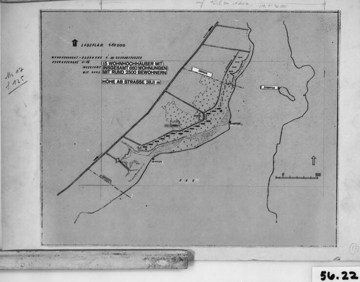
This is an image of a black and white map or plan, presented within a frame or mounted on a board. The map shows a section of land adjacent to a body of water, possibly a river or a coastline. There are marked areas with annotations, potentially indicating zones or areas of interest, written in a language that seems to be German, judging by the characters. The map includes a scale in the lower right corner, suggesting that this is a technical or planning document. In the lower right corner outside the map, there is a label with the text "56.22," which might refer to an archive or catalog number for the document. Handwritten text is visible on the edge of the frame or board, but it is not entirely legible in the image provided.
Created by gpt-4o-2024-05-13 on 2024-12-07
The image depicts a framed map with German text. There are several annotations and markings on it indicating different locations. Some of the text on the map reads: “LAGEPLAN 1:4000 15 WOHNHOCHHAUSER MIT INSGESAMT 660 WOHNUNGEN MIT RUND 2500 BEWOHNERN HOHE AB STRASSE 38.8 m” This translates roughly to: "LOCATION PLAN 1:4000 15 APARTMENT BUILDINGS WITH A TOTAL OF 660 APARTMENTS WITH ABOUT 2500 RESIDENTS HEIGHT ABOVE STREET 38.8 m" The map shows a layout of land including marked buildings and designated areas connected by roads. There are various symbols and possibly contour lines indicating the layout and elevation. The map is enclosed in a black frame, and there are some notes and dimensions visible on the edges. There is a label at the bottom right corner with the number "56.22".
Anthropic Claude
Created by claude-3-haiku-20240307 on 2024-12-07
The image appears to be a black-and-white map or layout of a residential area. The map shows a block of houses labeled "Wohnhausanlagen", which likely refers to residential buildings or housing complexes. The map contains various markings and labels, but no human faces are visible. The image seems to be a technical or architectural document, possibly related to urban planning or housing development.
Created by claude-3-5-sonnet-20241022 on 2024-12-07
This appears to be a historical German map or site plan, likely from around World War II based on the style and labeling. The map shows what appears to be a residential or housing development layout, with German text indicating measurements and specifications. The scale is 1:40000 as noted in the legend. There's a road or street marked with a height measurement of 38.8m ("HÖHE AM STRASSE 38.8 m"). The map has various dotted and dashed areas indicating different zones or land uses, and includes a north arrow. The image is in black and white and appears to be a photograph or copy of an original document, with the reference number "54.22" visible in the corner. The layout shows a somewhat elongated plot of land with various subdivisions and markings, bordered by what might be roads or property boundaries. The overall document appears to be mounted or framed in a dark border, suggesting it's likely an archived or documented historical plan.
Meta Llama
Created by us.meta.llama3-2-11b-instruct-v1:0 on 2024-12-07
The image appears to be a scanned black and white map, possibly from an old document or blueprint. The map is framed in a black border, with a white background and a grayish tone. It features a mix of handwritten and printed text in German, along with various symbols and markings. The map appears to be a top-down view of a property or land area, with several buildings and structures marked. There are also several lines and symbols indicating roads, paths, and other features. In the bottom-right corner, there is a small white label with the number "56.22" written in black ink. The overall appearance of the map suggests that it may be an old or historical document, possibly from the 20th century. The use of handwritten text and the lack of digital graphics or other modern elements support this interpretation. The map's purpose is unclear, but it may have been used for planning, surveying, or other purposes related to the property or land area depicted.
Created by us.meta.llama3-2-90b-instruct-v1:0 on 2024-12-07
The image presents a black-and-white map, likely a historical or archival document, featuring a detailed illustration of a landscape with various geographical features and markings. The map is framed within a white border, which is itself enclosed by a black frame. A small white label in the bottom-right corner displays the number "56.22" in black text. **Key Features:** * **Map Content:** The map showcases a landscape with roads, buildings, and other geographical features. It includes German text, indicating that it may be related to a specific location or project in Germany. * **Frame and Border:** The map is surrounded by a white border, which is then enclosed by a black frame. This framing suggests that the map is being preserved or displayed for historical or archival purposes. * **Label:** The small white label in the bottom-right corner bears the number "56.22" in black text. This label may serve as an identifier or catalog number for the map within a larger collection or archive. **Overall Impression:** The image appears to be a scanned or photographed version of a physical map, possibly from an archive or museum collection. The presence of German text and the detailed illustration of the landscape suggest that the map is related to a specific location or project in Germany. The framing and labeling of the map indicate that it is being preserved and displayed for historical or archival purposes.
Amazon Nova
Created by amazon.nova-pro-v1:0 on 2025-03-01
The image is a black-and-white photograph of a framed architectural or engineering plan. The frame is rectangular with a dark border, and the plan inside is mounted on a white background. The plan appears to be a detailed layout, possibly of a building or a complex structure. It includes various lines, labels, and annotations, which are likely to denote different sections, measurements, or specifications. The plan is titled "LAGEPLAN 1:4000" at the top, indicating that it is a site plan at a scale of 1:4000. There are also some handwritten notes and numbers on the left side of the plan, possibly indicating specific areas or measurements. The overall appearance suggests that this is a professional document used for construction or planning purposes.
Created by amazon.nova-lite-v1:0 on 2025-03-01
The image appears to be a black-and-white map or plan of some sort, possibly a map of a property or land area. The map is framed within a black border and has a number "56.22" in the bottom right corner. The map itself shows a layout of roads, buildings, and other features, with various labels and annotations in German. The map appears to be a technical or professional document, possibly used for planning or surveying purposes.
Text analysis
Amazon