Human Generated Data

Title

Housing Development, Berlin-Wannsee, 1930-1931: Map of Berlin, 1:60,000

Date

1930-1931

People

Artist: Walter Gropius, German 1883 - 1969

Classification

Prints

Credit Line

Harvard Art Museums/Busch-Reisinger Museum, Gift of Walter Gropius, BRGA.56.2

Human Generated Data

Title

Housing Development, Berlin-Wannsee, 1930-1931: Map of Berlin, 1:60,000

People

Artist: Walter Gropius, German 1883 - 1969

Date

1930-1931

Classification

Prints

Credit Line

Harvard Art Museums/Busch-Reisinger Museum, Gift of Walter Gropius, BRGA.56.2

Machine Generated Data

Tags

Amazon
created on 2022-06-04

Map 97.4
Diagram 97.4
Plot 91.3
Atlas 89.9
Soil 59.8

Clarifai
created on 2023-10-31

map 99.6
cartography 99.3
margin 98
geography 97.6
no person 96.3
graph 96.2
old 94.7
antique 94.2
wall 91.7
soil 91.3
retro 90.8
atlas 90.6
science 90.6
symbol 89.4
desktop 88.9
vintage 86.2
blank 85.8
diagram 85.5
chalk out 84.1
picture frame 82.2

Imagga
created on 2022-06-04

vintage 55.5
grunge 54.5
old 54.4
frame 54.2
texture 48
tray 45.3
antique 45.2
retro 41.8
wall 40.3
blackboard 37.7
receptacle 36.7
border 35.3
aged 34.4
blank 30
dirty 29.9
material 29.5
empty 28.4
ancient 27.7
structure 27.6
design 27
damaged 26.7
rusty 26.7
container 26.5
grungy 24.7
pattern 24.6
paper 24.3
board 23.1
art 22.5
rough 21.9
space 21.7
backdrop 20.6
chalkboard 20.6
textured 20.2
black 18.7
television 18.1
wallpaper 17.6
text 17.5
old fashioned 17.1
weathered 17.1
decoration 16.6
cash machine 15.8
screen 15.6
graphic 15.3
brass 15
frames 14.7
chalk 14.6
crumpled 14.6
messy 14.5
obsolete 14.4
concrete 14.4
interior 14.2
surface 14.1
your 13.5
decay 13.5
rust 13.5
school 13.5
parchment 13.4
memorial 13.3
highly 12.8
grime 12.7
mottled 12.7
fracture 12.7
stains 12.7
faded 12.7
brown 12.5
edge 12.5
detailed 12.5
stain 12.5
spot 12.5
nobody 12.5
device 12.4
education 12.1
machine 12.1
grain 12
wood 11.7
crack 11.6
wooden 11.4
monitor 11.1
paint 10.9
gray 10.8
broad 10.8
photographic 10.8
film 10.6
dirt 10.5
worn 10.5
learn 10.4
telecommunication system 10.4
stone 10.3
page 10.2
historic 10.1
dark 10
decorative 10
element 9.9
scratch 9.8
tracery 9.8
ragged 9.8
backgrounds 9.7
succulent 9.7
classroom 9.7
announcement 9.7
aging 9.6
framework 9.5
display 9.4
study 9.3
note 9.2
ornate 9.2
painting 9
rotting 8.9
building 8.9
crease 8.8
album 8.8
symbol 8.8
stained 8.7
3d 8.5
style 8.2
idea 8
copy 8
cement 7.9
scratches 7.9
gallery 7.9
exhibition 7.8
scratched 7.8
abandoned 7.8
color 7.8
scrapbook 7.8
insulating material 7.8
construction 7.7
computer 7.7
illuminated 7.6
sheet 7.5
close 7.4
message 7.3
digital 7.3
business 7.3
detail 7.2
home 7.2
architecture 7

Google
created on 2022-06-04

Map 90.7
Rectangle 87.6
Branch 86.7
World 86.4
Tree 82.3
Art 80.5
Twig 79.1
Font 77.8
Wood 76.4
Monochrome photography 72.9
Monochrome 72.9
Pattern 72
Atlas 70.2
Illustration 68.7
Visual arts 68
Painting 65.7
Drawing 64.5
Paper 63.6
Stock photography 61.8
Still life photography 59.8

Microsoft
created on 2022-06-04

gallery 99.5
room 98.6
wall 98.1
map 97.7
indoor 97.6
scene 95.6
picture frame 83
white 62.2
old 46.1
painting 42.5

Color Analysis

Feature analysis

Amazon

No features identified

Clarifai

Picture frame

Clarifai

Picture frame 99.3%

Categories

Imagga
created on 2022-06-04

paintings art 95.5%
text visuals 4.3%

Captions

Microsoft
created by unknown on 2022-06-04

a painting in a frame hanging on a wall 78.7%
a painting hanging on a wall 78.6%
a painting on the wall 78.5%

Salesforce

Created by general-english-image-caption-blip-2 on 2025-07-02

a map of the city of berlin, with the names of the streets and the names of

Created by general-english-image-caption-blip on 2025-05-15

a photograph of a map of the city of london, england

OpenAI GPT

Created by gpt-4 on 2024-12-07

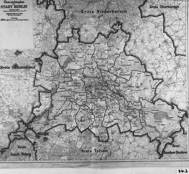
The image is a black and white photograph of an old map. The map is titled "Übersichtsplan STADT BERLIN" which translates to "Overview Plan CITY OF BERLIN". The map is detailed, with multiple areas demarcated and labeled, such as "Kreis Niederbarnim," "Kreis Teltow," and others. These names suggest that the map is likely of an area in Germany, with Berlin at the center. The map is in a frame, and it looks like it is under glass due to reflections visible on the surface. There is a slight tear or damage to the bottom left of the map, indicating it may be an older or well-used item. The number "502" is written in the lower-right corner, possibly an archive or inventory number.

Created by gpt-4o-2024-05-13 on 2024-12-07

The image depicts an antique map titled "Übersichtsplan Stadf Berlin." It appears to be a detailed black-and-white map of Berlin and its surrounding regions, delineating various districts and regional boundaries. Several regions are labeled, including "Kreis Niederbarnim," "Kreis Osthavelland," "Kreis Oberbarnim," "Kreis Zauch-Belzig," "Kreis Teltow," and "Kreis Beeskow-Storkow." The map is mounted in a rectangular frame, suggesting it is a historical or preserved document. The intricate lines and markings likely represent roads, settlements, and possibly elevation or other geographical features. A small label at the bottom right corner reads "562."

Anthropic Claude

Created by us.anthropic.claude-3-5-sonnet-20241022-v2:0 on 2025-06-25

This is a historical map titled "Übersichtsplan STADT BERLIN" (Overview Plan of the City of Berlin). It appears to be a black and white administrative or district map showing Berlin and its surrounding areas. The map shows different administrative districts (Kreis) including Niederbarnim, Oberbarnim, Osthavelland, Teltow, and Zauch-Belzig. The city of Berlin is shown in the center with its various neighborhoods and districts marked out. The map includes detailed topographical features and appears to be from an earlier period, possibly early-to-mid 20th century, given its style and presentation. The image is framed in what appears to be a black border or frame, and there's a small number "542" visible at the bottom right corner.

Created by claude-3-haiku-20240307 on 2024-12-07

The image appears to be a black and white map of a region in Germany. The map shows various counties or districts, including Stadt Berlin, Kreis Niederbarnim, Kreis Oberhavel, Kreis Teltow, and Kreis Zossen-Beelitz. The map seems to be a detailed topographical representation of the area, with various towns and villages labeled. There are no human faces or identifiable individuals visible in the image.

Created by claude-3-5-sonnet-20241022 on 2024-12-07

This is a historical map showing "Stadt Berlin" (City of Berlin) and its surrounding districts. It appears to be a black and white overview map showing the administrative boundaries of Berlin and its neighboring regions (Kreise). The map shows several districts including Kreis Niederbarnim to the north, Kreis Oberhavel to the west, Kreis Teltow to the south, and other surrounding administrative areas. The central part of the map shows the more densely developed urban area of Berlin itself. The map includes topographical details and appears to be from an earlier period, likely early-to-mid 20th century based on its style and presentation. It's preserved as what appears to be an archival photograph or document, as indicated by the framing and number "542" visible at the bottom.

Meta Llama

Created by us.meta.llama3-2-11b-instruct-v1:0 on 2024-12-07

The image depicts a framed map of Berlin, Germany, with a black border and a white background. The map is in black and white and appears to be an old document.

  • The map is titled "Übersichtsplan STADT BERLIN" in the top-left corner.
    • The title translates to "Overview Plan CITY BERLIN".
  • The map shows the city of Berlin divided into several districts, each labeled with its name.
    • The districts are:
      • Kreis Niederbarnim
      • Kreis Oberbarnim
      • Kreis Osthavelland
      • Kreis Teltow
      • Kreis Beeskow-Storkow
      • Kreis Zauch-Belsig
  • The map also shows roads, rivers, and other geographical features.
    • The roads are represented by lines, while the rivers are shown as wavy lines.
  • The map is surrounded by a black border, which adds a touch of elegance to the overall design.
    • The border is thin and does not obstruct the view of the map.
  • The background of the image is a plain gray color, which helps to focus attention on the map.
    • The gray background is a neutral color that does not compete with the map for attention.

In summary, the image shows a framed map of Berlin, Germany, with a black border and a white background. The map is titled "Übersichtsplan STADT BERLIN" and shows the city divided into several districts, each labeled with its name. The map also shows roads, rivers, and other geographical features. The black border adds a touch of elegance to the overall design, while the gray background helps to focus attention on the map.

Created by us.meta.llama3-2-90b-instruct-v1:0 on 2024-12-07

The image depicts a map of Berlin, Germany, with the title "Übersichtsplan STADT BERLIN" in the top-left corner. The map is presented in black and white, featuring a white background with a black border. It appears to be an old map, possibly from the early 20th century, given its vintage style and the presence of German text.

The map showcases various districts and neighborhoods within Berlin, including Kreis Niederbarnim, Kreis Oberbarnim, Kreis Osthavelland, Kreis Zauch-Belzig, Kreis Teltow, and Kreis Beeskow-Storkow. These areas are outlined in black, providing clear boundaries between them.

In the bottom-right corner of the map, a small white label bears the number "562." This label may indicate the map's catalog number or a reference code for archival purposes.

Overall, the image presents a historical map of Berlin, offering insight into the city's layout and administrative divisions during a specific period in the past.

Amazon Nova

Created by amazon.nova-lite-v1:0 on 2025-02-27

The image shows a map of Berlin, Germany, from the 1930s. The map is displayed in a glass frame with a black border, and it appears to be an old, black-and-white photograph. The map is divided into different regions, including "Kreis Niederbarnim," "Kreis Oberbarnim," "Kreis Teltow," "Kreis Zauch-Belzig," and "Kreis Beeskow-Storkow." The map also includes the names of various towns and villages within these regions. The map is labeled with the text "Ubersichtsplan der Stadt Berlin" (Overview map of the city of Berlin), indicating that it was likely used for planning and administrative purposes.

Created by amazon.nova-pro-v1:0 on 2025-02-27

The image features a black-and-white map of the city of Berlin, Germany. The map is framed in a black border and is titled "Übersichtsplan Stadt Berlin," which translates to "Overview Plan of the City of Berlin." The map includes various districts and neighborhoods within the city, such as Kreuzberg, Friedrichshain, Mitte, and others. The map also includes a small inset map of the city center, which highlights specific landmarks and areas of interest. The map appears to be a historical document, as it is dated "1939" in the bottom right corner.

Google Gemini

Created by gemini-2.0-flash-lite on 2025-04-28

Here's a description of the image:

Overall Impression:

The image presents a framed, black-and-white map. The map itself seems to be a historical plan, likely of a city or region. The framing is a classic black frame, which adds a formal and somewhat archival feel to the piece.

Map Details:

  • Subject: The map is labeled "Übersichtsplan STADT BERLIN", which translates to "Overview Map CITY BERLIN".
  • Content: The map depicts Berlin, with surrounding regions or "Kreis" (districts) indicated. Key districts labeled include: "Kreis Oberbarnim", "Kreis Niederbarnim", "Kreis Osthavelland", "Kreis Zauch-Belzig", "Kreis Teltow", and "Kreis Beeskow-Storkow".
  • Style: The map uses intricate line work to show roads, buildings, and other geographical features. The overall aesthetic suggests an old or vintage cartographic style.
  • Condition: The map appears to be aged. There's some subtle discoloration and creases, suggesting its historical origin.

Framing and Mounting:

  • Frame: The map is encased in a thick black frame.
  • Mounting: It looks like the map is mounted behind a white mat board. The mat helps to isolate and emphasize the map within the frame.
  • Additional Note: The number "56.2" is visible in the bottom right corner. This could be a reference number for the item.

Created by gemini-2.0-flash on 2025-04-28

Here's a description of the image:

The image is a black and white photograph of a framed map. The map appears to be an "Übersichtsplan" (overview map) of "STADT BERLIN" (City of Berlin). It shows the city and its surrounding areas, marked by administrative districts or "Kreis" such as "Kreis Niederbarnim," "Kreis Oberbarnim," "Kreis Osthavelland," "Kreis Zauch-Belzig," "Kreis Teltow," and "Kreis Beeskow-Storkow."

The map has a detailed network of roads, boundaries, and possibly other geographic or infrastructural elements. There is also a key or legend on the left side of the map. The framing of the map consists of a white border close to the map itself and a thick black frame. A number "56.2" is written on the bottom right of the frame's white border.

Mistral Pixtral

Created by us.mistral.pixtral-large-2502-v1:0 on 2025-04-28

The image is a black-and-white map titled "Übersichtsplan STADT BERLIN," which translates to "Overview Map of the CITY OF BERLIN." The map appears to be from the early to mid-20th century, as indicated by the style and the administrative divisions shown.

The map is divided into several districts, each labeled with its name. The districts (Kreise) shown on the map include:

  1. Kreis Niederbarnim (in the northeast)
  2. Kreis Oberbarnim (in the east)
  3. Kreis Teltow (in the south)
  4. Kreis Zauch-Belzig (in the southwest)
  5. Kreis Osthavelland (in the west)
  6. Kreis Bomstow-Storkow (in the southeast)

The map shows detailed street layouts within the city of Berlin and the surrounding areas, indicating various neighborhoods and their boundaries. The streets are depicted with fine lines, and the map includes various landmarks and geographical features.

The map is framed and appears to be displayed, possibly for educational or historical purposes. The number "50.2" is visible in the bottom right corner, which might be a catalog or inventory number.

Qwen

Text analysis

Amazon

56.2
Kreis
Übersichtsplan
Kreis Osthavelland
Zauch-Belzig
BERLIN
STADT BERLIN
Kreis Oberbarnim
Osthavelland
Oberbarnim
STADT
Kreis Teltow
Beeskow-Storkow
Teltow
-
Kreis Niederbarnim
- -
Niederbarnim
COPERICE
- معا
Sugar
معا

Google

Übersichtsplan STADT BERLIN ABA d shay Kreis Osthavelland Kreis Zauch-Belzig Kreis Niederbarnim- 5- Kreis Teltow Kreis Oberbarnim Kreis Beeskow-Storkow 56.2
Übersichtsplan
STADT
BERLIN
ABA
d
shay
Kreis
Osthavelland
Zauch
-
Belzig
Niederbarnim
5
Teltow
Oberbarnim
Beeskow
Storkow
56.2