Machine Generated Data
Tags
Color Analysis
Feature analysis
Amazon
| Airplane | 83.5% | |
Categories
Imagga
| paintings art | 98.3% | |
| interior objects | 1.3% | |
Captions
Microsoft
created by unknown on 2022-06-04
| a flat screen tv sitting in a room | 64.2% | |
| a flat screen tv sitting on top of a window | 48.9% | |
| a flat screen tv | 48.8% | |
Clarifai
created by general-english-image-caption-blip on 2025-05-21
| a photograph of a black and white photo of a drawing of a plane | -100% | |
OpenAI GPT
Created by gpt-4 on 2024-12-07
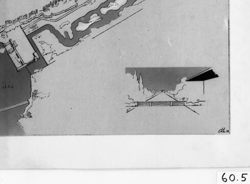
This is a black and white photograph of a framed map or diagram hung on a wall or placed on a surface. The content of the map is difficult to discern due to the angle and the possible glare on the glass. However, there are linear features resembling streets or paths, and some shaded areas that could represent geographic features like land or water. On the bottom right corner of the frame, there's a number "60.5" which could be a reference or inventory number for the map. There's a reflection on the glass that covers the map, indicating it is behind a reflective surface, likely glass. The map is oriented diagonally within the frame, from the top left corner to the bottom right corner, with a dark arrow pointing towards the upper right, which typically indicates north on maps. There are also various marks and shadows on the photograph, which may be due to the age of the photograph or the conditions under which it was taken.
Created by gpt-4o-2024-05-13 on 2024-12-07
The image depicts a detailed plan or map of a coastal area with various structures and features. Key elements include:
- A waterfront with a pier or jetty extending into the water.
- Several buildings or facilities near the shoreline.
- A series of interconnected waterways or canals inland from the main water body.
- Vegetation or tree-lined areas around the waterways.
- The presence of roads or pathways leading to and from the coast.
- An inset map in the lower right corner providing additional details or a different perspective of the area.
The map is bordered by a black frame and has a label "60.5" in the lower right corner.
Anthropic Claude
Created by claude-3-haiku-20240307 on 2024-12-07
The image appears to be an architectural drawing or plan of a coastal area. It shows a harbor or marina with a shoreline and buildings or structures. The drawing includes an overview map of the area as well as a more detailed sketch. The image appears to be in black and white, with the details rendered in a technical, schematic style.
Created by claude-3-5-sonnet-20241022 on 2024-12-07
This image appears to be an architectural or site planning drawing, shown in black and white. It looks like an aerial view or map of a waterfront development or harbor area. The main drawing shows what appears to be a pier or dock structure extending into a body of water, with what might be a marina or series of waterways extending to the right. Below the main drawing is a smaller inset sketch that appears to be a cross-section or elevation view of some part of the development. The drawing is presented in a frame or mount, with what appears to be the number "60.5" visible in the bottom right corner. The style suggests this might be a historical planning document or architectural proposal.
Meta Llama
Created by us.meta.llama3-2-11b-instruct-v1:0 on 2024-12-07
The image presents a black-and-white photograph of a framed architectural drawing, showcasing a detailed plan for a building or structure. The drawing is set against a light gray background and features a dark gray border around the edges.
Key Features:
- Framing: The drawing is encased in a black frame with a white matting, adding a touch of elegance to the overall presentation.
- Drawing: The architectural drawing itself is rendered in black and white, providing a clear and concise visual representation of the design. It appears to depict a building or structure with multiple levels, featuring a mix of straight lines and curved elements.
- Scale: A small scale is visible in the bottom-right corner of the drawing, indicating the size of the structure in relation to the surrounding environment.
- Background: The background of the image is a light gray color, which helps to highlight the details of the drawing and frame.
Overall Impression:
The image suggests that the architectural drawing is a significant and important document, possibly used for planning or construction purposes. The level of detail and precision in the drawing implies that it was created by a skilled architect or designer. The use of a black-and-white color scheme adds a sense of timelessness and sophistication to the image, making it suitable for a variety of contexts, including academic or professional settings.
Created by us.meta.llama3-2-90b-instruct-v1:0 on 2024-12-07
The image is a black and white map of a coastal area, featuring a body of water with a shoreline and various landmasses. The map appears to be hand-drawn and includes several symbols and markings that are not immediately clear.
Key Features:
- A large body of water dominates the left side of the map, with a shoreline that curves inward at the top and outward at the bottom.
- Several landmasses are visible, including a large island in the center of the map and smaller islands scattered throughout the water.
- A series of lines and symbols are drawn along the shoreline, possibly indicating the location of buildings, roads, or other features.
- In the bottom-right corner of the map, a small inset shows a close-up view of a specific area, possibly highlighting a particular feature or landmark.
- The map is surrounded by a white border, which is in turn surrounded by a black border. The overall effect is one of a formal, professional document.
Conclusion:
Based on the content and style of the map, it is likely that this image is a historical or archival document, possibly created for use in a specific context such as urban planning or navigation. The level of detail and the use of symbols and markings suggest that the map was intended for use by someone with specialized knowledge or training.
Amazon Nova
Created by amazon.nova-pro-v1:0 on 2025-03-01
The image is a black-and-white photograph of a framed drawing. The drawing is of a map, and it appears to be a detailed plan of a city or town. The map shows the layout of the streets, buildings, and other structures. The drawing is framed in a black frame with a white border. The frame has a label that reads "60.5" on the bottom right corner.
Created by amazon.nova-lite-v1:0 on 2025-03-01
The image appears to be a framed black and white map or diagram. The map shows a coastal area with a harbor or port, with various buildings, structures, and waterways depicted in detail. The map has a scale of 60.5 at the bottom, indicating the distance represented on the map.
The map is displayed on a white background, and the frame is black with a thin white border. The image is slightly blurry, which may be due to the age or quality of the original photograph or print.
Overall, the image provides a detailed view of a coastal area, likely for navigational or planning purposes. The inclusion of the scale suggests that the map was intended to be used for precise measurements or calculations.
Google Gemini
Created by gemini-2.0-flash-lite on 2025-04-28
Here's a description of the image:
The image shows a black and white architectural plan or drawing. It appears to be a detailed map or schematic of a coastal area, possibly a design for a harbor, port, or waterfront development.
Key Elements:
- Layout: The primary focus is on a long, irregularly shaped area with water features (possibly a river or inlet) winding through it. There is a dark, shaded area likely representing landmass.
- Structures: The drawing depicts buildings, docks, and possibly other infrastructure associated with a waterfront environment. At the bottom, a smaller detail of a building.
- Scale and Presentation: The drawing is framed, and appears to be a print or reproduction. The frame is surrounded by clips.
- Numbers and Markings: The plan includes various lines, shapes, and symbols to represent different elements. The number "1" at the top right may be a key or a reference point.
Overall, it's a technical drawing, likely intended to convey information about the layout and design of a coastal project.
Created by gemini-2.0-flash on 2025-04-28
Here is a description of the image:
The image is a black-and-white photograph of an architectural or planning drawing, possibly a schematic diagram of a coastal or waterfront development. The drawing is framed within a double border of white and black, and there are silver metal clips visible on either side of the drawing.
The central drawing depicts a landscape with water features, likely representing a coastal area or estuary. There's a darker area to the left, possibly a land mass or mountain range, adjacent to a body of water. The water features include what appears to be a pier or jetty extending into the water, along with a breakwater structure.
The land area contains a series of interconnected waterways, suggesting a canal or river system. Along the edges of the waterways, there are linear elements that could represent roads or pathways lined with vegetation or buildings.
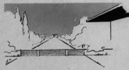
In the bottom right corner of the drawing, there is a smaller inset drawing showing an architectural elevation, possibly a building or structure planned for the site. A signature or initials, "dm," are faintly visible near the inset drawing.
At the bottom right corner of the frame, there is a notation, "60.5," which might be a serial number or an identifier. The overall impression is that of a technical drawing used for urban planning or architectural design purposes.
Mistral Pixtral
Created by us.mistral.pixtral-large-2502-v1:0 on 2025-04-28
The image is a black-and-white photograph of a framed map or architectural drawing. The drawing appears to depict a layout of a coastal area with various features. Here are some detailed observations:
Framing and Display: The drawing is framed with a thick black border and is mounted on a backing board with a white mat. There are two vertical glass or plastic rods on either side of the frame, possibly for protection or display purposes.
Drawing Details:
- Geographical Features: The map shows a coastal region with a body of water on the left side. There is a peninsula or landmass extending into the water.
- Structures and Labels: There are several structures and labels on the map. Notable features include:
- A labeled area that reads "FORT ZEELANDIA," suggesting this might be a historical or military site.
- A road or pathway leading to the fort.
- Various buildings or structures within the fort area.
- A smaller inset map or detail in the bottom right corner, which might provide additional information about a specific part of the main map.
Numbering: The number "60.5" is visible at the bottom right corner of the frame, which could be a reference or catalog number.
Artistic Style: The drawing has a detailed and precise style, typical of architectural or topographical maps. The shading and line work suggest it might be an old or historical document.
Overall, the image appears to be a detailed map or plan of a coastal fortification, possibly of historical significance, displayed in a protective frame.
Text analysis
Amazon