
Machine Generated Data
Tags
Color Analysis
Feature analysis
Amazon
Clarifai

AWS Rekognition
| Monitor | 72.9% | |

Categories
Imagga
created on 2022-06-04
| paintings art | 95.9% | |
| food drinks | 1.6% | |
Captions
Microsoft
created by unknown on 2022-06-04
| a flat screen television | 43% | |
| a flat screen tv | 42.9% | |
| a flat screen tv sitting in a room | 33.4% | |
Clarifai
No captions written
Salesforce
Created by general-english-image-caption-blip-2 on 2025-07-02
a black and white map of los angeles
Created by general-english-image-caption-blip on 2025-05-04
a photograph of a black and white photo of a map of a city
OpenAI GPT
Created by gpt-4 on 2024-12-07
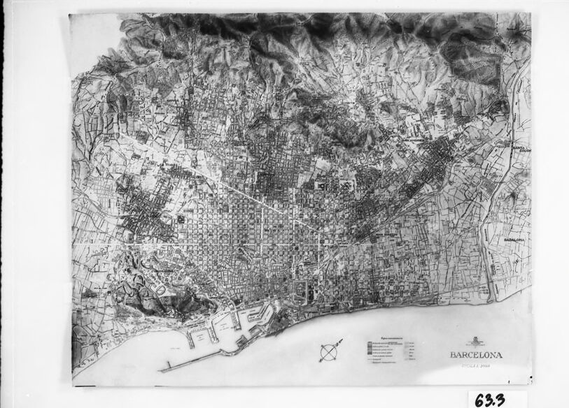
The image shows a framed black and white map of Barcelona, a city in Spain. The map is quite detailed, displaying an extensive grid-like pattern of streets and blocks, indicative of urban planning. On the lower right side of the map, there is a title that reads "BARCELONA ESCALA 1:5000," suggesting the map's scale. In the same area, there are symbols with a legend that explains the symbols used on the map. Surrounding the city, the topography appears to be illustrated, showing varying terrain or elevation outside of the developed urban area. This is further evidenced by the mountainous contours toward the top part of the map, contrasting with the structured urban layout. The map is slightly wrinkled on the left-hand side, indicating it may be an older document or has been subject to some wear. There is a small label with the number "63" in the lower right corner below the map, possibly an inventory or item number.
Created by gpt-4o-2024-05-13 on 2024-12-07
The image depicts a framed map of Barcelona, Spain. The map is detailed and appears to be a historical or older map presenting a bird's-eye view of the city's layout. The city grid is visible, with streets, buildings, and other city infrastructure. The Mediterranean Sea is shown along the bottom edge of the map, indicating that the city is coastal. There are labels and a legend in the lower-right corner of the map, along with a compass rose. The frame is rectangular and black, with a white mat surrounding the map. The number "633" is noted in the bottom right corner outside the framed area.
Anthropic Claude
Created by us.anthropic.claude-3-5-sonnet-20241022-v2:0 on 2025-06-25
This is a black and white map or aerial view of Barcelona, Spain. The image shows the city's distinctive grid pattern layout, particularly in the Eixample district, as well as the coastline along the Mediterranean Sea at the bottom. The mountainous areas surrounding the city can be seen in the darker shaded regions at the top and sides of the map. The port area is visible along the waterfront, and the overall urban development pattern of the city is clearly depicted with its streets, blocks, and major thoroughfares. The map appears to be a historical or archival document, given its monochromatic appearance and traditional cartographic style.
Created by claude-3-haiku-20240307 on 2024-12-07
The image appears to be a black and white aerial map of the city of Barcelona. The map shows a detailed, densely populated urban area with a complex network of streets and buildings, surrounded by mountainous terrain. There is a scale and legend provided at the bottom of the map. The overall impression is of a comprehensive cartographic representation of the city and its geography.
Created by claude-3-5-sonnet-20241022 on 2024-12-07
This is a historical map or plan of Barcelona, Spain, shown in black and white. The map appears to be quite detailed, showing the city's grid-like street pattern in the central district (likely the Eixample area) and the more irregular street layouts in the older parts of the city. The coastline is clearly visible along the bottom of the map, including what appears to be the port area. The topography of the surrounding hills and mountains is indicated through shading or contour lines. The map has a compass rose and what looks like a legend or key in the bottom right corner. It's presented in a frame with the number "633" visible at the bottom. The level of detail suggests this was likely used for urban planning or administrative purposes.
Meta Llama
Created by us.meta.llama3-2-11b-instruct-v1:0 on 2024-12-07
The image depicts a map of Barcelona, Spain, with a black frame and white background. The map is in black and white and appears to be hand-drawn or printed on paper.
- The map is centered in the frame and takes up most of the space.
- It shows the city's layout, including roads, buildings, and landmarks.
- The map also includes a compass rose in the bottom-left corner, which indicates the direction of north.
- There are several symbols and markings on the map, but they are not clearly legible.
- The frame is black and has a thin border around the edge.
- It is made of a smooth, matte material that reflects light evenly.
- The frame is slightly raised from the wall, giving it a 3D appearance.
- The background of the image is a light gray color.
- It provides a neutral backdrop for the map and frame.
- There are no other objects or features in the background that distract from the map.
Overall, the image presents a clear and detailed view of Barcelona's layout, making it useful for navigation or planning purposes.
Created by us.meta.llama3-2-90b-instruct-v1:0 on 2024-12-07
This image presents a black and white map of Barcelona, Spain, set against a white background and encased in a black frame. The map is oriented with north at the top, featuring a key in the bottom-left corner that provides information on the map's scale and other details. A small logo and the word "BARCELONA" are situated in the bottom-right corner.
The map itself is a detailed representation of the city, showcasing its streets, buildings, and other geographical features. The surrounding area, including mountains and the sea, is also depicted. The overall design of the map suggests that it was created for navigational purposes, providing users with a clear and concise visual representation of the city's layout.
In the bottom-right corner of the frame, a small white label bears the number "63.3" in black ink. This label may serve as an identifier or catalog number for the map, indicating its place within a larger collection or archive.
Amazon Nova
Created by amazon.nova-lite-v1:0 on 2025-02-26
The image shows a black-and-white map of the city of Barcelona, Spain. The map is framed in a black frame with a white border. The map shows the city's streets, buildings, and landmarks, including the famous Sagrada Familia cathedral. The map also includes a compass rose in the bottom right corner, indicating the cardinal directions. The map appears to be an old photograph, with a slightly blurry and faded quality.
Created by amazon.nova-pro-v1:0 on 2025-02-26
The image is a framed, black-and-white map of Barcelona. The map is printed on a transparent sheet of paper, and the frame is black. The map is placed on a gray surface. The map shows the city's layout, including its streets, buildings, and landmarks. The map is labeled with the name of the city, "Barcelona," and the year it was created, "1933." The map also includes a compass rose and a scale to help orient the viewer.
Google Gemini
Created by gemini-2.0-flash-lite on 2025-04-28
Here's a description of the image:
Overall Impression:
The image is a framed, black and white photograph or print of a map. The map depicts the city of Barcelona, Spain. It appears to be an older map, possibly a topographical one, due to the way the terrain is rendered.
Details:
- Framing: The map is presented in a black frame. The image itself is set within a white matting, which adds to the presentation.
- The Map: The map itself is intricate and detailed, with a large central portion of the city laid out in a grid-like pattern, characteristic of Barcelona's famous "Eixample" district. The map includes:
- Topographical details: Mountains or hills are depicted, especially towards the northern and western parts of the map.
- Coastline: The Mediterranean Sea is visible along the lower part of the map, with the port of Barcelona clearly outlined.
- Urban Areas: Buildings, streets, and infrastructure are meticulously drawn.
- Labels: The word "Barcelona" is visible, as well as other details.
- Scale and Legend: There appears to be a key or a scale at the bottom, which likely provides information about the map's scale and symbols.
- Number: A small handwritten number, "633," is on the white matting at the bottom right. This might be a catalog or inventory number.
- Overall Style: The image has a vintage or archival feel due to its monochrome nature. It looks like a historical document or a piece of cartographic art.
Created by gemini-2.0-flash on 2025-04-28
Here is a description of the image:
The image shows a framed black and white map of Barcelona. The map is detailed, depicting the city's layout, coastline, and surrounding mountainous terrain. The grid-like street pattern of the city is prominent, especially in the central areas. A harbor with piers is visible along the coastline. The bottom right corner of the map contains a legend and the city's name, "BARCELONA," with what appears to be a date below it. A white mat board surrounds the map, and a black frame encases the entire composition. The number "63.3" is written on the mat board below the map. The image appears to be a photograph of the framed map.
Mistral Pixtral
Created by us.mistral.pixtral-large-2502-v1:0 on 2025-04-28
The image depicts a detailed, black-and-white map of Barcelona, Spain. The map appears to be an old, possibly historical, representation of the city's layout. It shows the intricate grid pattern of streets, blocks, and urban areas, as well as the coastal region along the Mediterranean Sea.
Key features of the map include:
- The city's grid-like street pattern, particularly in the central areas.
- The port area at the bottom of the map, indicating Barcelona's significant maritime presence.
- The hilly and mountainous regions to the northwest, suggesting topographical features.
- A legend or key in the bottom right corner, which likely explains the symbols and markings used on the map.
- The word "BARCELONA" prominently displayed, confirming the city depicted.
- The number "693" written in the bottom right corner, which might be an identifier or catalog number.
The map is framed, suggesting it might be part of a collection or display. The detailed street layout and topographical features provide a comprehensive view of Barcelona's urban and natural geography.
Qwen
Created by Qwen/Qwen2.5-VL-7B-Instruct on 2025-07-26
The image shows a grayscale map of Barcelona, Spain. The map is detailed, showcasing urban布局, infrastructure, and geographical features. The area depicted includes the city's coastal regions and the surrounding hills. The map is bordered by a white margin, and a black frame surrounds the entire image, indicating it might be part of a collection or archive. In the bottom right corner of the map, the word "BARCELONA" is clearly visible, along with a scale and some symbols for orientation and location. The bottom left corner of the image has a label "63.3," which could indicate a catalog number or an identifier within a series. The map itself appears aged, with some wear and slightly faded details, suggesting it might be an older document.
Created by Qwen/Qwen2.5-VL-72B-Instruct on 2025-07-26
The image shows a map of Barcelona, Spain. The map is framed and appears to be a black and white or grayscale drawing. It includes a detailed depiction of the city's layout, with various streets, buildings, and geographical features such as mountains and the coastline. The map is oriented with north at the top, as indicated by the compass rose in the lower right corner. The text "BARCELONA" is written at the bottom of the map, and the number "63.3" is visible in the lower right corner of the frame. The map is mounted on a white background within a black frame, which is placed against a light-colored wall.
Text analysis
Amazon


