Machine Generated Data
Tags
Color Analysis
Feature analysis
Amazon
| Book | 98.6% | |
Categories
Imagga
| paintings art | 91.5% | |
| text visuals | 6.9% | |
| food drinks | 1.3% | |
Captions
Microsoft
created on 2019-11-09
| a close up of text on a whiteboard | 75% | |
| a close up of a whiteboard | 73.9% | |
| a whiteboard with writing on them | 73.8% | |
OpenAI GPT
Created by gpt-4 on 2025-02-05
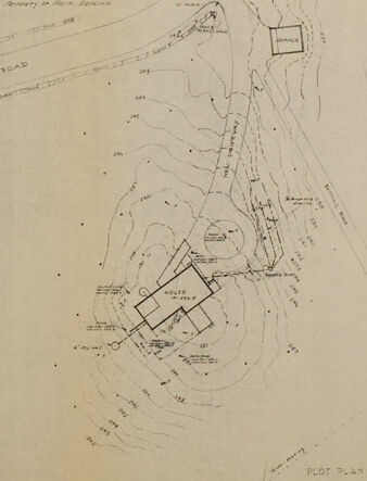
The image displays a vintage plot plan or map, which appears to be a technical drawing that illustrates the layout of a particular area or property. The drawing is on a large sheet of paper with visible folding marks and slight discoloration, suggesting age. The plan includes contour lines indicating the topography or elevation changes in the terrain. It shows the outline of a structure or building, with designated areas or sections within it, as well as pathways or roads leading to and around it. There are annotations and labels, likely explaining the different components of the plan, their dimensions, or other relevant data. Adjacent to the map, on the right-hand side, is a small compass rose indicating the north direction, which is a common element in maps to provide orientation. There's a title at the bottom right corner which is not clearly legible due to the resolution of the image provided. This kind of map might be used for a range of purposes, from architectural planning and construction to historical documentation of a site.
Created by gpt-4o-2024-05-13 on 2025-02-05
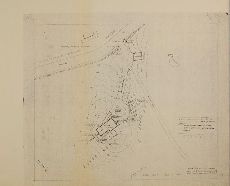
The image depicts an architectural drawing or site plan. The drawing is oriented towards the lower right quadrant of the paper, leaving a significant portion of the upper and left areas blank. The details within this plan include: - Contour lines suggesting varied topography or elevation changes. - Labels for roads and pathways, indicating existing and possibly proposed routes. - Various structural elements, likely buildings, marked with labels such as "house." - A circular shape representing either a significant landmark or area of interest. - General labels and measurements providing scale and context. A compass in the drawing helps indicate the orientation, with a scale provided to translate measurements. The lower right corner includes text with specifics about the drawing's purpose and its creators, typically containing information like the name of the project, the architects, date, and scale ratio. This drawing appears to be an early-stage plan, likely used for site analysis or initial design proposals.
Anthropic Claude
Created by claude-3-5-sonnet-20241022 on 2025-02-05
This appears to be an architectural or site plan drawing. It shows a topographical layout with contour lines indicating elevation changes and what looks like building footprints or structures plotted on the site. The drawing is rendered in black and white and appears to be a technical document, likely used for construction or property planning purposes. The plan shows roads or pathways and various geometric shapes representing different structures or areas on the property. There's some text and notations visible, though they're not clearly legible in this image. The drawing has a professional, technical quality typical of architectural or engineering documentation.
Created by claude-3-opus-20240229 on 2025-02-05
The image shows a technical plot plan or site survey drawing. It depicts the layout and dimensions of what appears to be a residential property or building lot. Various measurements, lines, and annotations are included to specify the location and size of different features on the site, such as property boundaries, setbacks, and proposed structures or improvements. The drawing is done in black ink or pencil on tan or aged paper, giving it a vintage look typical of older architectural or surveying documents.
Created by claude-3-haiku-20240307 on 2025-02-05
The image appears to be a plot plan or map of a geographic area. It contains various markings and labels, indicating features such as roads, buildings, or other structures. The map seems to be a technical document, likely used for planning or development purposes, as it provides detailed information about the layout and features of the depicted location.
Meta Llama
Created by us.meta.llama3-2-11b-instruct-v1:0 on 2025-03-11
The image depicts a hand-drawn map on a piece of paper, likely created for architectural or planning purposes. The map is drawn in pencil and features a series of lines, symbols, and text that appear to represent various elements such as buildings, roads, and other features. **Map Features:** * The map is drawn on a piece of paper with a light brown color. * The paper has a rough texture and appears to be aged, with some creases and folds visible. * The map itself is drawn in pencil and features a range of lines, symbols, and text. * The lines are thin and delicate, with some appearing to be more prominent than others. * The symbols include small circles, squares, and triangles, which may represent different types of buildings or features. * The text is written in a small, cursive font and appears to be a combination of labels and notes. * Some of the text is illegible, while other parts are clear and readable. **Background:** * The background of the image is a plain gray color. * There are no other objects or features visible in the background, which suggests that the image is a close-up shot of the map. **Overall:** * The image appears to be a detailed and intricate map, likely created for a specific purpose such as architectural planning or urban design. * The use of pencil and paper suggests a more traditional or analog approach to map-making, which may be contrasted with modern digital tools and techniques. * The image provides a glimpse into the process of creating a map, highlighting the attention to detail and care that goes into drawing and labeling each feature.
Created by us.meta.llama3-2-90b-instruct-v1:0 on 2025-03-11
The image depicts a hand-drawn map or blueprint, likely created for planning purposes. The map is drawn in pencil on a yellowed piece of paper, with a central focus on a building and its surroundings. **Key Features:** * **Building:** A rectangular structure with a smaller extension to the right, possibly representing a house or other type of building. * **Surroundings:** The building is situated within a larger area, with various lines and markings indicating boundaries, roads, or other features. * **Labels and Annotations:** Several labels and annotations are scattered throughout the map, although they are difficult to read due to the low resolution and faded nature of the image. * **Scale and Orientation:** The map appears to be oriented with north at the top, but the scale is not clearly indicated. * **Background:** The background of the image is a plain beige color, suggesting that the map may have been scanned or photographed against a neutral surface. **Possible Context:** Based on the content and style of the map, it is likely that it was created for a specific project or proposal, such as a construction plan or land development scheme. The level of detail and the presence of labels and annotations suggest that the map was intended for use by professionals or stakeholders involved in the project. **Conclusion:** In summary, the image presents a hand-drawn map or blueprint that appears to be related to a construction or land development project. While the specific details and context are unclear, the map provides a glimpse into the planning and design process involved in such projects.
Amazon Nova
Created by amazon.nova-pro-v1:0 on 2025-02-05
The image depicts a plot plan of a specific area. It is a detailed drawing that includes various elements, such as roads, buildings, and other structures. The plot plan is drawn on a piece of paper with a beige background. The paper appears to be old, as it has some stains and creases. The plot plan is divided into several sections, each representing a different part of the area.
Created by amazon.nova-lite-v1:0 on 2025-02-05
The image is a vintage plot plan, likely from the early 20th century, given the style and quality of the paper and ink. The plot plan is centered on a large rectangular area labeled "HOUSE" and "HOUSE PLOT," indicating it is a residential property. The plan includes detailed annotations and measurements, with various lines and numbers marking specific areas and dimensions. The plot is bordered by a road on the left side, indicated by a thick line and labeled "ROAD." The plot plan shows the house's position relative to the road and other features on the property. There are several smaller rectangles and squares marked throughout the plot, possibly indicating different sections of the property, such as gardens, driveways, or other structures. The top right corner of the plot plan includes a small circle with a line through it, which could represent a compass rose or a specific point of interest. The plan is bordered by a thin black line, giving it a clean and professional appearance. The image has a vintage look, with a slightly yellowed paper and faded ink, suggesting it is an old document. The plot plan is a valuable historical record, providing insight into the layout and features of a residential property from the early 20th century.
Text analysis
Amazon