Machine Generated Data
Tags
Color Analysis
Feature analysis
Amazon
Clarifai
AWS Rekognition
| Bird | 72.6% | |

Categories
Imagga
created on 2022-06-04
| text visuals | 98.4% | |
| paintings art | 1.2% | |
Captions
Microsoft
created by unknown on 2022-06-04
| an old photo of a computer | 51.4% | |
| an old photo of a computer screen | 43.2% | |
| a screen shot of a computer | 43.1% | |
Clarifai
No captions written
Salesforce
Created by general-english-image-caption-blip on 2025-05-21
a photograph of a map of a map of a map of a river
Created by general-english-image-caption-blip-2 on 2025-07-02
a map of the area of the israeli border
OpenAI GPT
Created by gpt-4 on 2024-12-07
This is a black and white photograph of a map. The map appears to be a historical or archival document mounted on a backing material, which is then framed within a black border, possibly for display or preservation purposes. The map is detailed and includes text and various linework to denote what could be geographical features, boundaries, and areas of interest. There is handwriting in the upper left corner that seems to be a reference or catalog mark, as well as a number '32' in the top right corner, likely signifying its sequence in a collection.
Due to the perspective of the shot, the text on the map is not clearly legible, making it difficult to determine the exact content or location represented. However, it seems to illustrate a land area with different sections marked, and might include features such as roads or paths, land plots, or topographic information. There are indications of some form of water bodies or rivers drawn in as well.
At the bottom of the image, there are additional annotations or reference numbers such as '50.43', which might be a cataloguing system for the map within an archive or library system. This suggests that the map is part of a larger collection or set of maps.
Created by gpt-4o-2024-05-13 on 2024-12-07
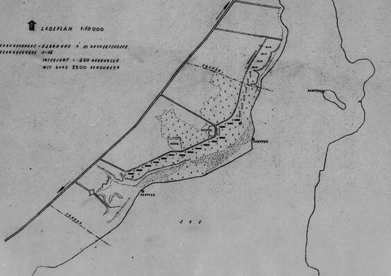
The image shows a historical map or design plan, labelled as "Lageplan 1:10.000" at the top. The map appears to depict a layout of a certain geographical area with various zones and features marked. It includes schema-like drawings of boundaries, pathways, water bodies, and different sections of land usage. The text on the map is in German, indicating details such as "Wohnhäuser" (residences) and "Lager" (camp), along with other annotations and labels.
The map is framed, possibly for preservation or display purposes. Around the edge of the frame are handwritten and printed numbers: "56.43" in the lower left-hand corner and "32" in a circle on the top right margin of the map, which likely refer to cataloging or indexing codes within a collection. The map itself is placed on a light background, and there are additional marks and notes written outside the frame.
Anthropic Claude
Created by us.anthropic.claude-3-5-sonnet-20241022-v2:0 on 2025-06-25
This image appears to be a historical map or survey document. It shows what looks like a coastal or waterfront area with some basic geographical features marked. The map is in black and white/grayscale and appears to be fairly simple in its detail. There are some dotted areas that might represent settlements or terrain features, and there are clear boundary lines drawn. In the top left corner, there appears to be some kind of directional indicator or compass rose. The document has reference numbers visible (56.43) and appears to be a photographed or scanned historical document, as evidenced by the frame and slightly aged appearance of the paper.
Created by claude-3-haiku-20240307 on 2024-12-07
This image appears to be a black-and-white map or diagram. It depicts a geographical area with various structures and landmarks marked. The map includes labels and numerical information, suggesting it is likely an engineering or architectural plan of some kind. The overall image appears to be a technical document or drawing rather than a photograph of a real-world scene.
Created by claude-3-5-sonnet-20241022 on 2024-12-07
This appears to be a black and white map or surveyor's drawing at a 1:40,000 scale, as indicated at the top of the image. It shows what appears to be a coastal or waterfront area, with linear boundaries and dotted areas that might represent settlements or developed regions. The map has a simple, technical style typical of military or planning documents, with minimal labels and clear geometric lines. There's a body of water visible on the right side of the map, and what looks like planned or existing infrastructure along the shoreline. The image is framed in what appears to be a photo or document mount, with reference numbers visible in the corners. The overall quality suggests this is a historical document or archive image.
Meta Llama
Created by us.meta.llama3-2-11b-instruct-v1:0 on 2024-12-07
The image presents a black and white map, likely from the 19th or early 20th century, featuring a detailed illustration of a land area with various markings and symbols. The map is surrounded by a thick black border, which is further encased in a white border. A handwritten note in the top-left corner reads "X/1," while another note in the bottom-right corner displays the number "56.43." The map itself appears to be a hand-drawn illustration, showcasing a land area with several buildings and roads. The map also includes a key or legend in the top-left corner, which provides information about the different symbols and markings used on the map.
The background of the image is a light gray color, which suggests that the map may have been scanned or photographed from a physical document. The overall appearance of the image is one of age and historical significance, with the black and white tones and handwritten notes evoking a sense of nostalgia and authenticity.
Created by us.meta.llama3-2-90b-instruct-v1:0 on 2024-12-07
The image depicts a black-and-white map, likely a historical or archival document, presented in a rectangular format with a white background and a black border. The map features a central area with a series of lines and markings, accompanied by text in an unknown language. A small white label at the bottom right corner displays the number "56.43" in black ink.
In the top-left corner, there are some handwritten notes, including what appears to be a date or code, "5039(?)", and another illegible symbol. The overall appearance of the image suggests that it is a scanned or digitized version of an original document, possibly from a historical archive or collection.
Amazon Nova
Created by amazon.nova-lite-v1:0 on 2025-02-25
The image is a black-and-white photograph of a map or diagram, possibly related to a land survey or real estate document. The map is framed within a black border and appears to be a plan or layout of a property. The map is labeled with various measurements and annotations, including "LAGEPLAN 1:4000" at the top, indicating a scale of 1:4000. The map shows a property with different sections and measurements, including "4-16" and "MIT 4000 SQUARES 1500 SQUARES." The map also includes a reference number "56.43" in the bottom right corner.
Created by amazon.nova-pro-v1:0 on 2025-02-25
The image is a black-and-white photograph of a framed map. The map is encased in a black frame with a white border, giving it a classic, archival look. The map itself is a detailed topographical representation of a specific area, possibly a rural or semi-rural region. The map is divided into sections by lines that may represent roads, paths, or boundaries. There are various markings and labels on the map, indicating different features such as bodies of water, elevations, and possibly land ownership or use. The top left corner of the frame has a handwritten note in black ink, which appears to be a reference number or identifier. At the bottom right corner of the frame, there is a label with the number "56.43," which could be a page number, a catalog number, or another form of identification. The overall appearance of the map suggests it is an older document, possibly from the early to mid-20th century, given the style of the frame and the quality of the photograph.
Google Gemini
Created by gemini-2.0-flash on 2025-04-28
Here is a description of the image:
The image shows a framed black-and-white photograph of a hand-drawn map. The map is detailed, showing a piece of land surrounded by water on one side. The land appears to be divided into several sections, some of which are labeled in German. There are also areas marked with trees or dense vegetation.
The frame is simple and black, and a white label with "56.43" written on it is visible in the lower right corner. The photograph appears to be taken indoors, and the lighting is even across the map. Overall, the image presents a clear view of a historical map within its framing.
Created by gemini-2.0-flash-lite on 2025-04-28
Here's a description of the image:
The image is a black and white photograph of a map, likely a topographical or area plan. Here's a breakdown:
- Framing: The photograph is presented within a black frame.
- Map Content: The map itself is the primary subject. It features a detailed drawing of a land area. Key elements of the map include:
- Coastline and bodies of water
- Roads and paths indicated by lines
- Areas shaded and possibly denoting vegetation or other features.
- Text and annotations.
- Labels and Text: The map has several pieces of text, some of which may contain information about the scale or other map conventions.
- Age/Condition: The map appears to be vintage due to the paper texture and tone of the photo.
- Additional Features: The picture is marked with some notes written in handwriting in the top-left corner (4/1, possibly a reference number or marking). A circular number "32" is in the top-right. The map itself is slightly discolored, which might be due to age or how it was stored. In the bottom right, there's the text 56. 43.
Mistral Pixtral
Created by us.mistral.pixtral-large-2502-v1:0 on 2025-04-28
The image is a black-and-white map, likely a historical military map, framed and displayed. The map appears to be a detailed layout of a specific area, possibly a battlefield or strategic location. Key features and annotations on the map include:
Scale: The map includes a scale indicator showing "LAGEPLAN 1:10000," meaning the map is drawn to a scale where 1 unit on the map represents 10,000 units in reality.
Legend: There is a legend in the upper left corner with various symbols and their meanings. The legend includes:
- A solid line representing a specific boundary or feature.
- Dotted lines indicating different types of boundaries or features, such as military lines or defensive positions.
- Other symbols that likely denote important landmarks, structures, or military installations.
Geographical Features: The map shows various geographical features such as rivers, roads, and possibly elevation changes. These are depicted with different line styles and shading.
Annotations: There are several annotations and labels on the map, including place names and possibly military designations. For example, the word "Rhein" (Rhine) is visible, suggesting the map might be of an area along the Rhine River.
Framing: The map is framed with a black border and has a label "St. 43" in the bottom right corner, which could be a reference or catalog number.
Overall, the map seems to be a detailed strategic or tactical map, possibly used for military planning or historical analysis.
Qwen
No captions written
Text analysis
Amazon