Machine Generated Data
Tags
Color Analysis
Feature analysis
Amazon
Clarifai

Clarifai
| Building | 65.9% | |


Categories
Imagga
created on 2018-03-23
| text visuals | 95.2% | |
| nature landscape | 2.9% | |
| events parties | 1.5% | |
| streetview architecture | 0.3% | |
Captions
Microsoft
created by unknown on 2018-03-23
| a blue and white text | 58.8% | |
| a black and silver text on the side of a mountain | 54% | |
| a black and silver text on a blue surface | 40.7% | |
Clarifai
No captions written
Salesforce
Created by general-english-image-caption-blip on 2025-05-11
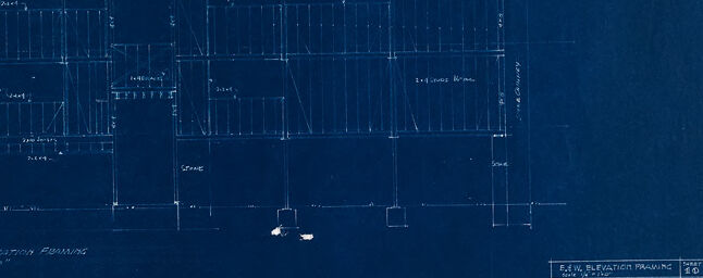
a photograph of a blueprinted drawing of a plan for a house
Created by general-english-image-caption-blip-2 on 2025-06-29
blueprint of a building with a blue background
OpenAI GPT
Created by gpt-4 on 2024-12-16
This image displays a set of architectural blueprints. The blueprints are rendered in white lines and text on a dark blue background, which is a characteristic of the cyanotype process often used for reproducing diagrams, known as blueprints.
The blueprint appears to be aged, with some tearing and damage along the edges, and folds visible, suggesting it has been handled and used over time. The document provides detailed plans, often used by architects, builders, and engineers as a guide for construction. There are annotations indicating dimensions and layout details, but any specific information regarding location or what the plans are for is not fully visible in the image.
The text on the blueprint seems to read "East Elevation Drawing" on the top and "West Elevation Drawing" at the bottom, indicating different views of the same structure or building project. In the lower right corner, there's text which usually specifies the project name, location, architect or engineer's names, and other relevant details about the blueprint, but the details cannot be read clearly.
Overall, the image conveys a glimpse into the process of architectural design and planning before the widespread use of digital drafting tools.
Created by gpt-4o-2024-05-13 on 2024-12-16
This image shows a deteriorated blueprint drawing with several tears and missing pieces along the edges. The blueprint contains architectural elevation plans, specifically labeled as "East Elevation Framing" and "West Elevation Framing," drawn to a scale of 1/4" = 1'-0". The diagram includes structural details and measurements. The bottom right corner contains text indicating that this is for "House for Mr. John Sergeant" located in Chatham, Massachusetts, and it was created by Walter Cropper Kinnicutt Jr., who is likely the architect. The blueprint appears old and worn with significant portions missing in the top and bottom right corners.
Anthropic Claude
Created by us.anthropic.claude-3-5-sonnet-20241022-v2:0 on 2025-06-24
This image appears to be an architectural blueprint or technical drawing, specifically showing elevation plans. The drawing is presented in white lines on a dark blue background, which is characteristic of a blueprint or cyanotype print. The drawing shows what appears to be elevation views (likely west elevation based on the partial text visible) of a building or structure, with various measurements and architectural details marked out. The image has some wear and tear visible, with torn or damaged edges, particularly noticeable around the borders. The drawing includes various horizontal and vertical lines indicating structural elements and dimensions, though some parts of the drawing appear faded or damaged.
Created by claude-3-haiku-20240307 on 2024-12-16
This image appears to be a blueprint or technical drawing. It shows detailed architectural plans or schematics, likely for a building or structure. The image is predominantly dark blue in color, with white lines and text indicating various structural elements, dimensions, and other technical specifications. The overall layout and design suggest this is an engineering or construction-related document, providing a detailed visual representation of the planned construction or design.
Created by claude-3-5-sonnet-20241022 on 2024-12-16
This appears to be an architectural blueprint or technical drawing, specifically showing elevation drawings of what seems to be a building structure. The image is rendered in white lines on a dark blue background, which is characteristic of vintage blueprints. The drawing shows both front and side elevations of the structure with detailed measurements and framing indications. The image has some damage or deterioration visible around the edges, appearing as torn or worn areas. The drawings include structural details like beams, supports, and dimensional notations. Based on the title block visible in the lower right corner, this appears to be an elevation drawing, though the specific details in the title block are not clearly legible in this image.
Meta Llama
Created by us.meta.llama3-2-11b-instruct-v1:0 on 2024-12-16
The image appears to be a blueprint or architectural drawing of a building, likely created in the early 20th century. The drawing is on a dark blue background with white lines and text, and it shows the floor plan of a multi-story building. The building has several rooms, including a living room, dining room, kitchen, bedrooms, and bathrooms. There are also stairs leading to the upper floors and a basement area.
The drawing includes various symbols and notations, such as arrows indicating the direction of doors and windows, and numbers and letters labeling different parts of the building. In the bottom-right corner, there is a small box with text that reads "ELEVATION FRONT" and "SIDE ELEVATION," which suggests that this is a front elevation drawing of the building.
Overall, the image provides a detailed and precise representation of the building's design and layout, which would have been useful for architects, builders, and other professionals involved in the construction process.
Created by us.meta.llama3-2-90b-instruct-v1:0 on 2024-12-16
The image depicts a blue architectural blueprint, which appears to be a floor plan for a building. The blueprint is torn and worn, with visible creases and tears throughout. It features white lines and text that outline the layout of the building, including rooms, corridors, and other architectural elements.
In the bottom-right corner of the blueprint, there is a small section of text that provides information about the project. This section includes details such as the name of the architect, the date of the design, and the location of the building. However, due to the poor condition of the blueprint, much of this text is illegible.
Overall, the image suggests that the blueprint is an old document that has been damaged over time. Despite its worn condition, it still provides valuable information about the design and layout of the building it represents.
Amazon Nova
Created by amazon.nova-lite-v1:0 on 2025-02-26
The image shows a blue architectural blueprint with a design for a building. The blueprint has several drawings and text written in white font. The blueprint is titled "Elevation Drawing" and is dated "1940." The drawing includes several lines and measurements, with the text "First Elevation Drawing" written on the top left side. The blueprint is in a damaged condition, with some parts missing.
Created by amazon.nova-pro-v1:0 on 2025-02-26
The image is a blueprint of a building's floor plan. The blueprint is printed on a blue sheet of paper, which has a few tears and creases. The floor plan is divided into two sections, with the upper section labeled as "Fifth Elevation Planning" and the lower section labeled as "First Elevation Planning." The blueprint includes measurements, dimensions, and other details, such as the location of doors, windows, and other features. The upper section of the blueprint shows a rectangular shape with a staircase on the right side, while the lower section shows a more complex layout with multiple rooms and corridors. The blueprint also includes a legend or key that explains the symbols and abbreviations used in the plan. Overall, the blueprint provides a detailed and precise representation of the building's floor plan, which would be useful for architects, engineers, and construction professionals.
Google Gemini
Created by gemini-2.0-flash-lite on 2025-05-02
Here's a description of the image:
Overall Impression:
The image is a blueprint, a type of architectural or engineering drawing. It's a dark blue sheet with white lines indicating a building design. The paper has a torn and aged appearance, with several large rips and tears along the edges and through the design.
Content:
- Drawings: The blueprint contains two main elevation drawings, likely showing the exterior of a building from different perspectives (East and West elevations are labeled). The drawings detail the structure's layout, including walls, windows, and potentially interior features like stairs.
- Text: There is text indicating the drawing is for a "HOUSE G. JOHN HAGERTY" and located in "CONASSET, MASS." The architects listed are "WALTER CROPIUS & MARCEL BREUER Associates Architects." Some other technical details are also present, such as the scale, sheet number, and potentially other information.
Style and Condition:
- Blueprint: The use of blue background and white lines is typical of the blueprint process.
- Aged Appearance: The ripped edges and discoloration suggest the blueprint is old and has been handled over time.
- Hand-drawn: The slightly uneven lines and handwriting imply that the original drawing was done by hand.
Created by gemini-2.0-flash on 2025-05-02
The image is a blueprint on dark blue paper that is torn along the edges. It features two sets of architectural drawings in white lines. The top drawing is labeled "EAST ELEVATICA FILAMING" while the bottom one is titled "WEST ELEVATION FIBAMING." Below the bottom drawing, there is text that includes "HOUSE JOPA HAGERTY AT MASS." and "WALTER CROPIUS MARCEL BA Associates Architects." The drawings appear to depict the elevations of a building, with lines and annotations indicating various structural elements.
Mistral Pixtral
Created by us.mistral.pixtral-large-2502-v1:0 on 2025-05-29
The image is a blueprint, a type of technical drawing used in architecture and engineering. Blueprints are typically blue with white lines, which is a result of a chemical process known as cyanotype. This particular blueprint appears to be an architectural drawing for a building.
Key features of the blueprint:
Elevations and Plans: The blueprint contains both elevation and plan views. The top section shows the "East Elevation & Planning" and the bottom section shows the "West Elevation & Planning."
Scale: The drawing is labeled with a scale of 1/4 inch = 1 foot, indicating the proportion between the drawing and the actual size of the building.
Details: The drawing includes detailed measurements and annotations, such as dimensions for various parts of the structure, room labels, and other architectural features.
Damage: The blueprint shows signs of wear and tear, with visible tears and cracks along the edges and some parts of the paper.
Attribution: The bottom right corner contains text that attributes the design to "John Russell Pope" and indicates that it was drawn by "Grosvenor Atterbury, Architect." The date on the blueprint is March 26, 1931.
Overall, this blueprint provides a detailed architectural plan and elevation views for a building, likely intended for construction purposes.
Qwen
No captions written
Text analysis
Amazon