Machine Generated Data
Tags
Color Analysis
Feature analysis
Amazon
Clarifai

Clarifai
| Picture frame | 99.6% | |
Categories
Imagga
created on 2022-06-04
| text visuals | 99.8% | |
Captions
Microsoft
created by unknown on 2022-06-04
| an old photo of a sign | 58.4% | |
| an old photo of a room | 58.3% | |
| an old photo of a person | 57.6% | |
Clarifai
No captions written
Salesforce
Created by general-english-image-caption-blip-2 on 2025-07-02
a black and white photo of a map of a golf course
Created by general-english-image-caption-blip on 2025-05-04
a photograph of a map of a map of a map of a city
OpenAI GPT
Created by gpt-4o-2024-11-20 on 2025-06-09
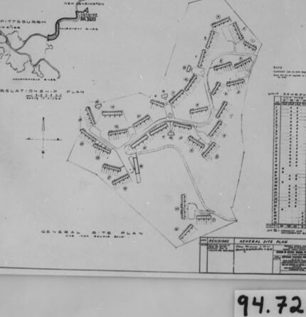
The image is a black-and-white photograph of a detailed map or plan, enclosed within a frame. The map appears to depict the layout of a site with various labeled sections and structures. Small text annotations are scattered throughout the map, accompanying the outlined structures and areas.
On the top portion, there seems to be a "relation map" indicating the position of Pittsburgh relative to the site. Below this, the main map outlines a general plan, showing multiple groups of structures laid out in an organized pattern, potentially representing buildings or housing. There is also a table or chart on the right side containing numerical data or schedules related to the site.
The frame contains a label at the bottom center with the number "94.72," possibly indicating an archive or catalog number for reference.
Created by gpt-4o-2024-08-06 on 2025-06-09
The image is a photograph of a framed architectural or site plan. The plan is titled "Over-All Site Plan" and is overlaid with a "Relationship Plan" inset on the upper left corner. The plan appears to be a detailed layout of a development or housing project, showing buildings, paths, and other site features. In the upper right, there is a chart or table, likely containing additional reference information or data relevant to the site. The bottom of the plan includes a title block, which might contain the project name, the designer's name, or other administrative details. In the inset map, a river or road leads to or from Pittsburgh.
The photograph is mounted within a black frame or border, and the image includes some visible imperfections or marks, possibly from the aging film or photograph. The number "94.72" is written on a label positioned below the plan, which might be a catalog or reference number related to the photograph or the project itself.
Anthropic Claude
Created by anthropic.claude-3-haiku-20240307-v1:0 on 2025-06-13
The image appears to be a blueprint or map of a location. It contains various lines, shapes, and labels that seem to represent different structures, roads, or other features of a planned or existing site. The map includes a scale and some numerical information, suggesting it is a technical or engineering drawing of some kind. There are no human faces or identifiable individuals visible in this image.
Created by us.anthropic.claude-3-opus-20240229-v1:0 on 2025-06-13
The image shows an architectural plan or blueprint of what appears to be a residential development or neighborhood. The plan includes a layout of streets, lots, and building footprints. Various measurements and annotations are provided on the plan. In the bottom right corner, a date of "94.72" is written, likely indicating the year this plan was created or last revised - 1972. The plan is mounted in a black frame against a textured gray background.
Created by us.anthropic.claude-3-5-sonnet-20241022-v2:0 on 2025-06-13
This image appears to be an architectural or site plan drawing, presented in a black-framed format. The drawing shows what looks like a layout or map with various buildings or structures arranged in a particular pattern. In the top left corner, there's a smaller inset map or location diagram. The main drawing shows multiple rectangular structures arranged along what appear to be pathways or roads. On the right side of the drawing, there's what looks like a data table or legend. The drawing has a number "94.72" marked on the bottom right corner of the frame. The image is in black and white and appears to be a technical or professional architectural drawing.
Meta Llama
Created by us.meta.llama3-2-11b-instruct-v1:0 on 2025-06-10
The image is a black and white photograph of a framed map, with a white background and a black border. The map appears to be a hand-drawn plan for a development or community, featuring various buildings and roads.
Here are the key elements of the image:
- Map:
- Hand-drawn plan for a development or community
- Features various buildings and roads
- Includes labels and symbols to identify different features
- Frame:
- Black border around the map
- White background
- Appears to be a standard frame used to display the map
- Background:
- White surface behind the frame
- May be a table or shelf
- Number:
- 94.72 written in black ink on a small piece of paper
- Located at the bottom of the image
- May be a reference number or code
Overall, the image appears to be a document or artifact related to urban planning or development, showcasing a specific plan or design for a community or area.
Created by us.meta.llama3-2-90b-instruct-v1:0 on 2025-06-10
The image depicts a black-and-white map, likely a blueprint or architectural drawing, featuring a detailed layout of buildings and roads. The map is presented in a rectangular format with a white background and a black border.
Key Features:
- A prominent title or label at the top-left corner reads "Pittsburgh" in bold letters.
- A smaller text below the title appears to be a date or code, but it is illegible due to the low resolution of the image.
- The map itself showcases various buildings, roads, and other infrastructure elements, including what appears to be a river or stream running through the center of the image.
- Several symbols and markings are scattered throughout the map, which may represent different types of buildings, utilities, or other features.
- In the bottom-right corner, a small white rectangle contains the text "94.72" in black ink.
Overall Impression:
The image suggests that this map is an official document or plan related to urban development or infrastructure projects in Pittsburgh. The level of detail and the presence of symbols and markings indicate that it is a technical drawing intended for professionals or stakeholders involved in the project.
Amazon Nova
Created by amazon.nova-pro-v1:0 on 2025-06-05
The image features a framed document with a black border, likely a map or a plan. The document appears to be a detailed layout or schematic, possibly of a city or an area. It includes various lines, shapes, and text that suggest a structured design or plan. The document is placed on a white surface, possibly a table or a wall, and is well-lit, indicating that it is meant to be viewed and studied closely.
Created by amazon.nova-lite-v1:0 on 2025-06-05
The image appears to be a map or blueprint of some kind, with a black border around the edges. The map itself is divided into two sections, with the upper section showing a river or waterway and the lower section showing a series of buildings or structures. The buildings are arranged in a grid-like pattern, with rows and columns of squares and rectangles. There are also some numbers and letters printed on the map, possibly indicating specific locations or features. The number "94.72" is prominently displayed in the bottom right corner of the image.
Google Gemini
Created by gemini-2.0-flash-lite on 2025-05-01
Here's a description of the image:
The image is a black and white photograph of a detailed architectural or site plan. The plan is mounted within a frame.
Key Features:
- The Plan: The core of the image is the plan itself, which shows a layout of a site with multiple buildings/structures.
- Elements of the Plan: The plan includes a few labeled areas, lines representing structures, roads, or paths, and a lot of annotations that seem to label the different structures.
- Relationship Plan: There's a "relationship plan" section indicating the geographic relationship between the site and Pittsburgh.
- Scale and Details: A scale, or legend, in the corner indicates the use of the plan.
- Framing: The plan is mounted within a larger frame. The frame itself adds an additional border.
- Number: The number "94.72" is printed on the bottom of the image.
Overall Impression:
The photograph gives off a vintage or historical feel. The plan itself is likely a technical drawing or blueprint.
Created by gemini-2.0-flash on 2025-05-01
Here's a description of the image:
The image shows a black and white photograph of a site plan or map that is framed and has the number "94.72" written at the bottom.
The document within the frame appears to be a technical drawing or blueprint titled "GENERAL SITE PLAN." The plan includes a "RELATIONSHIP PLAN" showing the location of Pittsburgh and New Kensington, PA, in relation to a river. The main part of the drawing depicts a site layout with what seem to be buildings or structures and pathways, with detailed notes and annotations. A table with rows and columns of information is included, potentially describing unit dimensions or other specifications.
The map is enclosed in a glass frame, which has a black border. The overall presentation gives the impression of an archived document or a historical record of a site plan.
Mistral Pixtral
Created by us.mistral.pixtral-large-2502-v1:0 on 2025-06-03
The image shows a framed architectural drawing or blueprint. The drawing appears to be a site plan, detailing the layout of a large area with multiple structures and roads. Here are the key features of the image:
Main Site Plan: The central part of the drawing shows a detailed layout of a site with numerous buildings, roads, and possibly other infrastructure. The buildings are represented by rectangular shapes, and the roads or pathways are depicted as lines connecting these structures.
Inset Map: In the upper left corner, there is a smaller inset map labeled "Pittsburgh" with a "New Station" marked, indicating the location of the site within the city of Pittsburgh. This inset provides context for the location of the main site plan.
Relation Plan: Below the inset map, there is a label that reads "Relation Plan," which likely refers to how the main site plan relates to the larger area shown in the inset map.
Elevation Drawing: On the right side of the main site plan, there is an elevation drawing of a tall building. This drawing shows the front view of the building, detailing its height and the arrangement of its floors.
Legend and Notes: At the bottom of the drawing, there are several sections with text, likely containing legends, notes, and other relevant information about the site plan and the structures depicted.
Framing: The drawing is framed with a black border, and there is a label at the bottom center of the frame with the number "94.72."
Overall, the image depicts a detailed architectural plan for a site in Pittsburgh, including both a bird's-eye view of the layout and an elevation drawing of a specific building.
Qwen
Created by Qwen/Qwen2.5-VL-7B-Instruct on 2025-07-26
The image appears to be a black and white photograph of a framed document. The document is a "General Site Plan," which is a type of architectural, engineering, or urban planning drawing that provides a detailed layout of a proposed or existing site. This particular plan includes a map with symbols that likely represent buildings, roads, pathways, and other structures. It also includes a compass rose, which indicates the cardinal directions (north, south, east, west), and a scale at the bottom of the map for measuring distances. The document is affixed to a light-colored background, and there is a numeric label "94.72" at the bottom right corner of the frame. The overall appearance suggests that this might be an archive or historical document, possibly related to urban development or a construction project.
Created by Qwen/Qwen2.5-VL-72B-Instruct on 2025-07-26
This image shows a framed architectural or urban planning document, specifically a site plan for a development or community. The plan includes several rows of buildings arranged in a grid-like pattern, with roads and pathways connecting them. There is a legend or key on the right side of the map, which likely explains the symbols used in the plan. In the top left corner, there is a small inset map showing the location of the site in relation to Pittsburgh, Pennsylvania, with a compass rose indicating the orientation. The bottom right corner of the frame has a label with the number "94.72." The overall style suggests this is a historical document, possibly from the mid-20th century.
Text analysis
Amazon