Machine Generated Data
Tags
Color Analysis
Feature analysis
Amazon
| Monitor | 89.1% | |
Categories
Imagga
| paintings art | 43.8% | |
| streetview architecture | 26.6% | |
| text visuals | 20% | |
| food drinks | 7.9% | |
Captions
Microsoft
created by unknown on 2022-06-04
| a flat screen television | 59.2% | |
| a flat screen tv | 59.1% | |
| a flat screen monitor | 57.8% | |
Clarifai
created by general-english-image-caption-blip on 2025-05-15
| a photograph of a black and white photo of a map of a map of the area | -100% | |
OpenAI GPT
Created by gpt-4 on 2024-12-07
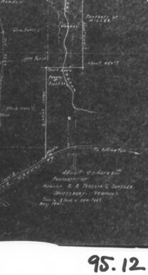
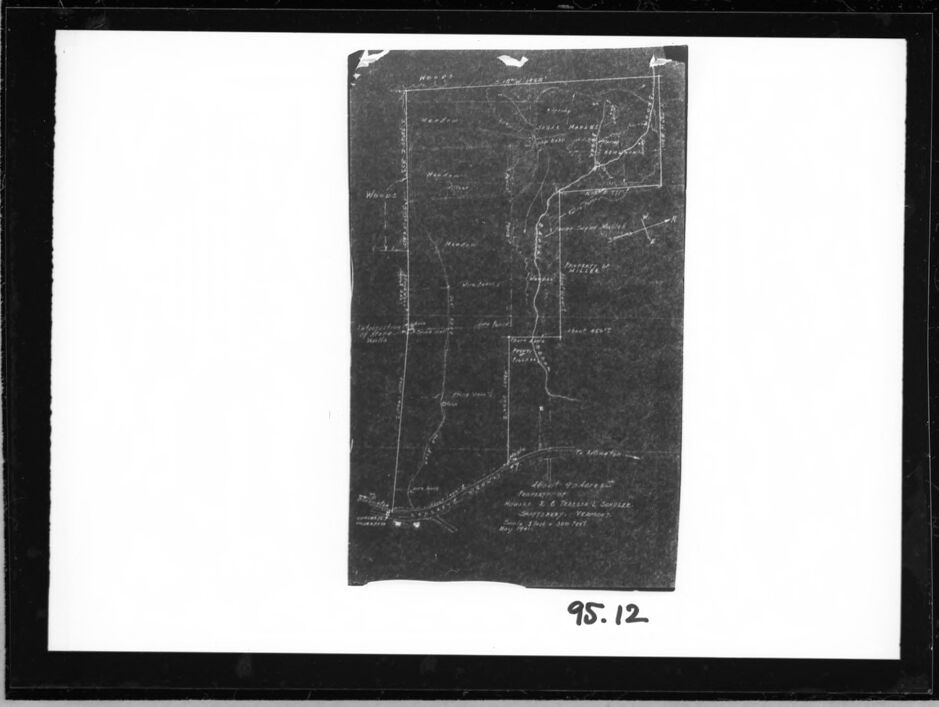
The image is a black and white photograph showing what appears to be a document, drawing, or map encased in a matte frame with a clear border between the frame and the image. The document within is dark with lighter lines and annotations indicating a schematic or map-like representation of an area or a system. There are several straight and curved lines, possibly roads or paths, and text that identifies certain features or locations, though they aren't clearly readable in this reproduction. In the bottom right corner, there's a numeric annotation "95.12", which might be related to cataloging or identification of the photograph or the document depicted. The photograph itself is well centered and taken straight-on to avoid perspective distortion.
Created by gpt-4o-2024-05-13 on 2024-12-07
The image is a black and white photograph of an old map. The map appears to be a hand-drawn or historical document with white and light-colored writing on a dark background. It shows various landmarks, boundaries, and annotations throughout, suggesting it depicts a geographical area possibly used for surveying or land division. There is some text visible, but it is hard to read due to the photograph's quality and the age of the document. At the bottom, handwritten in white appears to be a date or catalog number "95.12". The map is enclosed within a black border, making it stand out against the surrounding grayish-white background.
Anthropic Claude
Created by claude-3-haiku-20240307 on 2024-12-07
The image appears to be a black and white photograph of a map. The map contains various markings and labels, indicating it is likely a topographical or geographical map. There are numerous lines and shapes on the map, suggesting it depicts terrain, roads, or other geographical features. The map appears to be quite detailed, with various topographical elements and notations visible. The image is dated "95.12", which may indicate the year or time period the map was created.
Created by claude-3-5-sonnet-20241022 on 2024-12-07
This appears to be an old land survey map or property boundary document. It's a black and white image showing what looks like a rectangular plot of land with various boundary lines and markings. The map appears to be drawn on a dark background with white or light lines indicating the property boundaries and possibly topographical features. There's a number "95.12" written in the bottom right corner of the frame. The document itself seems to be photographed against a white background with a dark border around the edges. The map shows various linear divisions and what might be natural features like creeks or paths running through the property.
Meta Llama
Created by us.meta.llama3-2-11b-instruct-v1:0 on 2024-12-07
The image is a black and white photograph of a map, set against a white background with a black border. The map appears to be hand-drawn and features various lines and markings that suggest it is a topographical map or a map of a specific area.
Map Details:
- The map is drawn on a piece of paper that has been folded in half vertically, with the crease running down the center.
- The map is oriented with the top edge facing upwards and the bottom edge facing downwards.
- The map features several lines and markings that appear to represent roads, rivers, and other geographical features.
- There are also several handwritten notes and labels scattered throughout the map, which may indicate the names of places, landmarks, or other important features.
- The map appears to be quite detailed, with many small lines and markings that suggest it is a highly accurate representation of the area it depicts.
Background:
- The background of the image is a plain white color, which provides a clean and neutral backdrop for the map.
- The white background helps to highlight the details of the map and makes it easier to read and understand.
- There are no other objects or features visible in the background, which suggests that the image is a simple and straightforward representation of the map.
Border:
- The border around the image is a thick black line that adds a touch of contrast to the overall design.
- The black border helps to frame the map and creates a sense of depth and dimensionality.
- The border also adds a touch of sophistication and elegance to the image, making it more visually appealing.
Overall:
- The image is a clear and concise representation of a map, with a simple and effective design that makes it easy to read and understand.
- The use of a plain white background and a black border helps to highlight the details of the map and creates a sense of depth and dimensionality.
- The image is likely intended for use in a historical or educational context, where it can be used to illustrate the geography and layout of a specific area.
Created by us.meta.llama3-2-90b-instruct-v1:0 on 2024-12-07
The image is a black and white map of an area, possibly a town or city, with various roads and landmarks labeled. The map appears to be hand-drawn and features a mix of straight and curved lines, as well as some symbols and abbreviations.
Key Features:
- A large rectangle in the center of the image, which may represent a building or other structure.
- Several roads and streets, some of which are labeled with names such as "Main St" and "Church St".
- A few landmarks, including a church and a school.
- A small body of water, possibly a river or lake, which runs along the bottom edge of the map.
- A scale or legend in the bottom-right corner, which provides information about the map's orientation and measurements.
Overall Impression:
The map appears to be a detailed and accurate representation of the area it depicts. It is likely that the map was created for practical purposes, such as navigation or urban planning, rather than for aesthetic or artistic reasons. The use of simple lines and symbols suggests that the map was intended to be easy to read and understand, even for those who are not familiar with the area.
Amazon Nova
Created by amazon.nova-lite-v1:0 on 2025-02-24
The image is a black-and-white photograph of a document or a page from a book. The page has a rectangular shape with a black border around it, giving it a framed appearance. The content of the page is a map or a diagram, as indicated by the presence of lines, shapes, and possibly text or labels. The map or diagram appears to be a representation of a geographical area, possibly a town or a region. The map is divided into sections, with different lines and shapes indicating various features or landmarks. The map also includes text or labels, which are difficult to read due to the low resolution of the image. The number "95.12" is visible in the bottom right corner of the page, possibly indicating a page number or a reference number. Overall, the image appears to be a historical or archival document, possibly from a book or a report on a specific geographical area.
Created by amazon.nova-pro-v1:0 on 2025-02-24
The image is a monochromatic photograph of a document that appears to be a map or a chart. The document is rectangular and is surrounded by a black border. The background of the document is white, and the content of the document is black. The document contains a grid-like structure with various lines and text. The text is small and appears to be labels or annotations for the lines on the grid. The lines on the grid are of different lengths and orientations, suggesting that they may represent different types of data or information. The document also has a number "95.12" in the bottom right corner, which could be a reference number or a page number. Overall, the image appears to be a technical document that is used for data analysis or visualization.
Google Gemini
Created by gemini-2.0-flash-lite on 2025-04-28
Here's a description of the image:
The image presents a black and white scanned document, likely a map or a land survey plan. The document itself is rectangular, with some noticeable wear and tear, including a torn corner. The map's orientation is vertical.
The map appears to depict land features, including:
- Lines that likely represent property boundaries or roadways.
- Labels of features, potentially identifying landowners, landmarks, or geographical details like "Woods".
- A title or legend (partially visible at the bottom) that might provide details about the area or the survey itself.
- A section with the text "95.12"
The entire document is framed within a black border, suggesting it's either a photographic print or scanned from an original mounted document. The background is a neutral, light color.
Created by gemini-2.0-flash on 2025-04-28
Here is a description of the image:
The image shows a black and white photograph of a map surrounded by a black border. The map itself is detailed and appears to be an old survey or land division drawing. It includes various labels and markings indicating property lines, names of landowners, and geographical features. Some of the visible labels include "Woods," "Meadow," and the names "Miller" and "Shiller." There are also annotations and notations written on the map, indicating details about the properties or survey information. The map's paper has some creases and minor damage, which adds to the antique feel. At the bottom of the image, there's a clear label "95.12" written in a simple font. The overall presentation suggests that this is a historical document or a preserved record of land ownership and geographical information.
Mistral Pixtral
Created by us.mistral.pixtral-large-2502-v1:0 on 2025-04-28
The image appears to be a historical document or map, likely a survey or property map, mounted on a backing board. Here are some detailed observations:
Map Details:
- The map is hand-drawn and includes various lines and labels, indicating property boundaries, landmarks, or geographical features.
- Names and locations are written on the map, such as "Woods," "Harris," "Miller," and "Williams."
- There are several lines and measurements, which could be survey lines or property divisions.
- A river or stream is depicted running through the center of the map.
Document Condition:
- The map appears aged and possibly fragile, with some visible creases and signs of wear.
- The paper has a darkened, yellowed appearance, typical of old documents.
Mounting:
- The map is mounted on a white backing board with a black frame or border around it.
- The number "95.12" is written in the bottom right corner of the backing board, which might be a cataloging or reference number.
Handwritten Notes:
- There are handwritten annotations on the map, possibly indicating the surveyor's name, date, and other relevant information.
- The text at the bottom right of the map reads: "Surveyed by [illegible] Surveyor. Recorded [illegible] 1881. Book [illegible] Page [illegible]."
This document likely holds historical significance, possibly related to land surveys, property ownership, or early settlement mapping. The detailed hand-drawn nature and the aged condition suggest it is from the late 19th century.
Text analysis
Amazon