
Machine Generated Data
Tags
Color Analysis
Feature analysis
Amazon
| Clock Tower | 95.9% | |
Categories
Imagga
| text visuals | 91% | |
| interior objects | 4.1% | |
| paintings art | 2.9% | |
| food drinks | 1.7% | |
Captions
Microsoft
created on 2022-06-04
| a large clock mounted to the side | 72.2% | |
| a clock hanging on the wall | 64.1% | |
| a large clock mounted to a wall | 64% | |
OpenAI GPT
Created by gpt-4 on 2024-12-07
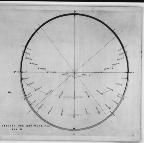
This is a black and white photo showing what appears to be a framed chart or diagram. The diagram has a large circle with a horizontal line that intersects the circle at its widest points, indicating East on the right and West on the left. Vertical lines intersect the middle of the circle, likely indicating North at the top and South at the bottom. The circle is divided into multiple sections with radial lines and there are markings along the inside edge of the circle, possibly representing degrees or another unit of measure. Each radial line has multiple small lines intersecting it with numbers and letters, suggesting some kind of measurement or scale. The bottom left corner of the diagram includes the text, "SUN DIAGRAM FOR KEY WEST FLA LAT 24," suggesting that this is a solar diagram specific for Key West, Florida, and its latitude which is 24 degrees. There's also a number "96.33" in the bottom right corner, possibly an inventory or reference number related to the photo or the item pictured.
Created by gpt-4o-2024-05-13 on 2024-12-07
The image depicts a framed diagram labeled "SUN DIAGRAM FOR KEY WEST FLA LAT 25" at the bottom center. The diagram consists of a large circle divided into segments, presumably indicating various times or positions related to the sun's movement. Lines radiate from the center of the circle, reaching outwards to points along the circumference, marking specific directions or times. There are notations and labels around the circle and along the radial lines. These marks likely represent solar angles, azimuths, altitudes, or times of day. The diagram is divided into four quadrants, with each quadrant marked by directional indicators (N for North, E for East, S for South, and W for West) and possibly other specific solar or geographical data points. In the lower right corner of the frame, the number "96.33" is visible, possibly indicating an archive or reference number. The overall appearance suggests that this diagram was used for educational or navigational purposes, specifically relating to the position and movement of the sun in Key West, Florida.
Anthropic Claude
Created by claude-3-haiku-20240307 on 2024-12-07
The image appears to be a black and white diagram or chart. It shows a circular diagram with various markings and labels around the circumference. The diagram seems to be some kind of navigational or surveying tool, possibly used for determining bearings or other spatial measurements. There are no human figures visible in the image.
Created by claude-3-5-sonnet-20241022 on 2024-12-07
This image shows a sun diagram or sun path chart, specifically labeled as "SUN DIAGRAM FOR KEY WEST FLA LAT 25". It's a circular diagram with radiating lines and markings around its circumference. The diagram appears to be a technical drawing or architectural tool used to track the sun's position and movement throughout the day at the specific latitude of Key West, Florida (25 degrees). It's presented in black and white, appears to be an older or historical document, and is framed within what looks like a photographic border or mount. This type of diagram would typically be used for solar studies, architectural planning, or navigation purposes.
Meta Llama
Created by us.meta.llama3-2-11b-instruct-v1:0 on 2024-12-07
The image is a black-and-white photograph of a sun diagram for Key West, Florida, dated 1898. The diagram is a circular chart with a central axis labeled "N" and "S," and lines radiating from the center to the edge, indicating the direction of the sun at different times of day. The chart also includes labels for the cardinal directions (north, south, east, and west) and the times of day (morning, noon, and evening). The diagram is mounted on a piece of paper or cardboard, which is placed in a black frame. The frame has a white matting around the edges, and a small label in the bottom-right corner that reads "96.33." The background of the image is a light gray color, with some darker gray shadows visible around the edges of the frame. Overall, the image appears to be a historical document or artifact related to navigation or astronomy, possibly used by sailors or travelers to determine the direction of the sun and plan their routes.
Created by us.meta.llama3-2-90b-instruct-v1:0 on 2024-12-07
The image presents a black-and-white diagram of a sun chart, titled "SUN DIAGRAM FOR KEY WEST FLA LAT 24." The chart is set against a white background and features a black border. At the bottom right corner, the number "9633" is handwritten in black ink. The sun chart itself is circular, with a central point marked by a small cross. Radiating from this center are lines that intersect at various points along the circle's circumference. These intersections are labeled with numbers and letters, likely representing different times of day or seasons. The chart appears to be a tool for tracking the sun's movement and position in the sky, possibly used for navigation or astronomical purposes.
Amazon Nova
Created by amazon.nova-lite-v1:0 on 2025-02-25
The image shows a black and white diagram of a sun dial. The sun dial is divided into sections with lines and numbers, indicating the time of day. The sun dial is mounted on a white background with a black border. The image also includes the text "SUN DIAGRAM FOR KEY WEST FLA" and the number "9633" in the bottom right corner. The image appears to be an old photograph, with a slightly grainy texture and a faded appearance.
Created by amazon.nova-pro-v1:0 on 2025-02-25
The image shows a sun diagram with a black border and the number "9633" at the bottom. The diagram consists of a circle with a radius of 24, divided into 12 equal parts, each representing an hour of the day. The diagram also includes a key for the west plane, which is labeled as "LAT 28." The sun's position is marked on the diagram, indicating the sun's path throughout the day.
Text analysis
Amazon


