Machine Generated Data
Tags
Color Analysis
Feature analysis
Amazon
Clarifai
AWS Rekognition
| Monitor | 91% | |

Categories
Imagga
created on 2022-06-04
| text visuals | 88.9% | |
| paintings art | 7.3% | |
| streetview architecture | 3% | |
Captions
Microsoft
created by unknown on 2022-06-04
| a flat screen television | 65.3% | |
| a flat screen television on the wall | 59.1% | |
| a flat screen tv | 59% | |
Clarifai
No captions written
Salesforce
Created by general-english-image-caption-blip-2 on 2025-06-29
a black and white photograph of a building plan
Created by general-english-image-caption-blip on 2025-05-03
a photograph of a black and white photo of a house with a clock
OpenAI GPT
Created by gpt-4 on 2024-12-07
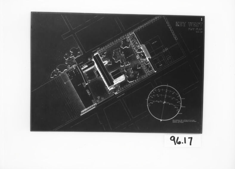
This image shows a framed photograph or a print of an aerial or satellite view of a location described as "KEY WEST FLT MAN." It is likely a portion of a map or a plan related to Key West, Florida, and "FLT MAN" might refer to some type of flight management or aeronautics-related content. There is also a compass rose in the bottom right corner, suggesting orientation with regard to cardinal directions. The picture or print has a number label, "96.17," possibly for inventory or archival purposes. The image is monochromatic and appears to be a negative, as the normally dark areas are light and vice versa.
Created by gpt-4o-2024-05-13 on 2024-12-07
The image appears to be a black and white photograph of a blueprint or plan drawing. The drawing is labeled "Key West Plot Plan." It shows detailed top-down architectural or site layout. The design includes multiple structures, pathways, green spaces with trees, and possibly recreational areas. There is also a circular diagram on the lower right side of the plan. In the bottom right corner, there is a handwritten number "96.17," which could be an archival or catalog reference. The drawing is placed inside a black frame with a white background.
Anthropic Claude
Created by us.anthropic.claude-3-5-sonnet-20241022-v2:0 on 2025-06-25
This appears to be an architectural or site plan drawing, likely from Key West based on the text visible in the image. It's a black and white aerial view or blueprint showing what appears to be a building layout with surrounding landscaping or grounds. The drawing includes a circular diagram in the lower right corner which is likely a compass rose or directional indicator. The image has a number "96.17" written in the bottom right corner and is presented in what appears to be a dark frame or border. The drawing style suggests this is a professional architectural or planning document, showing structural elements and property boundaries in a technical format.
Created by claude-3-haiku-20240307 on 2024-12-07
The image appears to be an aerial photograph or map of a building or structure. The image is in black and white and shows a complex grid-like pattern with various shapes and intersecting lines. There is also a circular element in the bottom right corner that looks like some kind of target or radar display. The image is labeled with the text "Hey wise" and the date "9.6.17" in the bottom left corner.
Created by claude-3-5-sonnet-20241022 on 2024-12-07
This appears to be an architectural or site plan drawing of Key West, shown in a negative or blueprint style format. The image shows what looks like a building layout or complex from an aerial view, with various structures, landscaping elements, and pathways marked out. There's a circular diagram in the lower right corner which is likely a compass rose or directional indicator. The drawing is presented in black and white, mounted in what appears to be a dark frame or border, and has the number "96.17" written in the bottom right corner. The lines and details are crisp, suggesting this is a professional architectural or planning document.
Meta Llama
Created by us.meta.llama3-2-11b-instruct-v1:0 on 2024-12-07
The image presents a black-and-white blueprint of a building, showcasing its layout and design. The blueprint is set against a white background, surrounded by a black border, and features a series of lines and symbols that indicate the location of various rooms, doors, windows, and other architectural elements.
Key Features:
- Building Layout: The blueprint displays the floor plan of the building, including the placement of rooms, corridors, and other features.
- Symbolism: The blueprint uses a range of symbols to represent different elements, such as doors, windows, and walls.
- Scale: The blueprint includes a scale, which allows the viewer to measure the size of the building and its various components.
- Orientation: The blueprint is oriented in a way that makes it easy to read and understand, with the main entrance at the top and the rooms and corridors arranged in a logical and coherent manner.
Overall Impression:
The blueprint provides a detailed and accurate representation of the building's design and layout, making it an essential tool for architects, engineers, and builders. Its clear and concise presentation allows the viewer to quickly understand the building's structure and functionality, making it an invaluable resource for anyone involved in the construction or renovation of the building.
Created by us.meta.llama3-2-90b-instruct-v1:0 on 2024-12-07
The image presents a black-and-white architectural drawing of a building, set against a white background and framed in black. The drawing is oriented at an angle, with the top-right corner pointing towards the upper right side of the image. A circular diagram is situated in the bottom-right corner of the drawing, while the words "KEY WEST" are visible in the top-right corner. The drawing appears to be a blueprint or technical illustration, likely created for architectural or engineering purposes.
In the bottom-right corner of the image, the number "96.17" is handwritten in black ink. This notation may indicate the drawing's identification number, version, or other relevant information. Overall, the image provides a detailed and technical representation of a building's design, suggesting its use in architectural or construction contexts.
Amazon Nova
Created by amazon.nova-lite-v1:0 on 2025-02-25
The image is a black-and-white architectural plan, likely from the 1960s, given the date "96.17" at the bottom. The plan is framed with a black border and appears to be a scaled drawing of a building or complex. The drawing includes various elements such as lines, symbols, and text. The text "KEY WEST" and "FIFTH PLAN" are prominently displayed at the top, suggesting this is a floor plan for a specific location or building. The image is a detailed representation of the layout, showing rooms, corridors, and possibly other architectural features. The drawing is placed centrally within the frame, and the background is plain, allowing the architectural details to stand out.
Created by amazon.nova-pro-v1:0 on 2025-02-25
The image shows a black-and-white architectural drawing of a building. The drawing is placed on a white background with a black border. It is a top-down view of a building, with a circular object on the right side. The drawing has the text "KEY WEST" at the top, and the number "96.17" is at the bottom. The drawing appears to be a floor plan or a blueprint of a building.
Google Gemini
Created by gemini-2.0-flash on 2025-04-28
The image shows a framed black and white photograph of a plot plan for Key West, Florida. The photograph is surrounded by a white matte and a black frame. The plot plan itself is a detailed architectural drawing, showing building layouts, landscaping, and a circular diagram. The words "Key West" and "Plot Plan" are visible on the top right of the drawing. Below the photograph, on the matte, the number "96.17" is handwritten.
Created by gemini-2.0-flash-lite on 2025-04-28
Here's a description of the image:
The image shows a blueprint or architectural plan framed in a black border with a white matting. The plan is a top-down view of a building complex, labeled "KEY WEST PLOT PLAN." It features detailed line drawings depicting the building's layout, surrounding landscape (including trees), and surrounding roads or infrastructure. A circular diagram is also included, likely a sun path or shadow analysis. The image has a stark contrast, with white lines against a dark background, typical of blueprints or architectural renderings. The number "96.17" appears below the architectural plan on the white background, likely a reference number or label.
Mistral Pixtral
Created by us.mistral.pixtral-large-2502-v1:0 on 2025-04-28
The image appears to be a framed architectural plan or blueprint. The plan is labeled "Key West" and "Plat Plan" at the top, suggesting it is a map or layout of a specific area in Key West. The plan includes detailed drawings of streets, buildings, and possibly other landmarks or features.
Key elements of the image include:
- Street Layout: The plan shows a network of streets, with various intersections and pathways clearly marked.
- Buildings and Structures: Several buildings and structures are depicted, possibly including residential, commercial, or public buildings.
- Labels and Annotations: There are labels and annotations within the plan, which might include street names, building names, or other relevant information.
- Compass Rose: In the bottom right corner, there is a compass rose, indicating the orientation of the map (north, south, east, west).
- Framing: The plan is framed with a black border, and there is a white mat surrounding the plan, giving it a polished and professional appearance.
- Numbering: The number "96.17" is written in the bottom right corner of the frame, which could be a reference or catalog number.
Overall, the image provides a detailed and organized representation of a specific area in Key West, likely used for urban planning, development, or historical documentation.
Qwen
Created by Qwen/Qwen2.5-VL-7B-Instruct on 2025-07-26
The image appears to be a black and white photograph of a blueprint or plan. The top right corner of the blueprint contains text that reads "KEY WEST PLANT PLAN." The blueprint itself seems to depict a layout of a facility or building complex, with various rooms, offices, and a central structure that could resemble a main building or administrative area. There are also some smaller structures and what appear to be landscaping elements, though the details are somewhat indistinct.
The bottom right corner of the photograph contains the number "96.17," which might be an identification or catalog number for the image or blueprint. The image is framed in black and is placed on a white background.
Created by Qwen/Qwen2.5-VL-72B-Instruct on 2025-07-26
This image shows a framed black-and-white map or layout plan labeled "Key West Plot Plan." The map appears to depict an aerial view of a specific area, potentially a property or a planned development. The layout includes buildings, pathways, and possibly landscaping features. There is a compass rose in the bottom right corner of the map, indicating the orientation. The number "96.17" is written in the bottom right corner of the frame, possibly indicating a catalog or reference number. The frame is black with a white mat, and the background is a neutral gray.
Text analysis
Amazon