Machine Generated Data
Tags
Color Analysis
Feature analysis
Amazon
Clarifai

Clarifai
| Picture frame | 99.6% | |
Categories
Imagga
created on 2022-06-04
| text visuals | 99% | |
Captions
Microsoft
created by unknown on 2022-06-04
| a painting hanging on a wall | 80.4% | |
| a painting on the wall | 80.3% | |
| a painting on a wall | 79.8% | |
Clarifai
No captions written
Salesforce
Created by general-english-image-caption-blip on 2025-05-20
a photograph of a map of a map of a map of a map of a city
Created by general-english-image-caption-blip-2 on 2025-07-02
a black and white photo of a map of a lake
OpenAI GPT
Created by gpt-4o-2024-11-20 on 2025-06-08
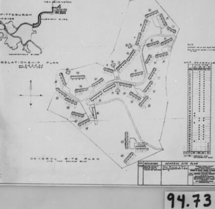
This image shows a framed layout map or blueprint with black and white markings. The map outlines a planned development or neighborhood, with roads and buildings arranged in an interconnected pattern. In the top-left corner, there is a smaller map detailing Pittsburgh's location and its relation to the specific site depicted. The main portion of the image displays a detailed site plan with numbered buildings, roads, and labels indicating the area layout.
There is also a chart or table visible on the right-hand side, possibly illustrating data related to the development (e.g., measurements or construction details). At the bottom, labeled as "94.73," appears to be an archival notation or catalog reference for the image. The entire map is mounted and framed, suggesting it may be part of a preserved historical or planning record.
Created by gpt-4o-2024-08-06 on 2025-06-08
The image depicts a framed black and white blueprint or plan drawing. This blueprint shows a map or layout, likely of a residential development, with various buildings and roads depicted in a schematic manner. The map includes labeled areas and a scale, as well as a directional compass indicating north. In the upper left corner of the map, there is an inset labeled "Relationship Plan" showing a simple map with locations including Pittsburgh and other landmarks or features like rivers or roads. To the right of the map, there is a chart with labeled columns, possibly detailing data relevant to the layout shown. In the lower right corner of the overall framed display, there is a white section with numbers written in bold black: "94.73". The entire map is encased in a border within the frame. The background of the framed item appears to be a light color, contrasting with the black frame surrounding it.
Anthropic Claude
Created by anthropic.claude-3-haiku-20240307-v1:0 on 2025-06-12
The image appears to be a black and white map or diagram. It shows a detailed layout of what seems to be a town or city, with various roads, buildings, and other structures marked on it. The map includes labels and numbers, suggesting it may be a technical or engineering drawing. There are no human faces or identifiable individuals visible in the image.
Created by us.anthropic.claude-3-5-sonnet-20241022-v2:0 on 2025-06-12
This image shows an architectural or site plan drawing in black and white, displayed in what appears to be a black frame. The drawing contains two parts - a small inset map in the upper left showing what looks like Pittsburgh and its surrounding area, and a larger detailed site plan showing the layout of various buildings or structures. The buildings are represented as rectangular shapes arranged along what appear to be roads or pathways. There's also what looks like a data table or legend in the lower right corner of the drawing. The number "99.73" is visible in the bottom right corner of the frame. The drawing appears to be a professional architectural or planning document, possibly showing the layout of some kind of facility or campus.
Meta Llama
Created by us.meta.llama3-2-90b-instruct-v1:0 on 2025-05-30
This image presents a black-and-white map, likely a site plan, set against a white background. The map is encased in a black frame and features a white border around it. A small white label at the bottom right corner of the map displays the number "94.73" in black text.
The map itself appears to be a hand-drawn illustration, showcasing various buildings and structures within a larger area. Although the details are not entirely clear due to the image's low resolution, the map seems to depict a campus or neighborhood with several buildings, roads, and other features. The presence of a key or legend on the right side of the map suggests that it may provide additional information about the different elements depicted.
Overall, this image appears to be a historical document or archival material, possibly related to urban planning, architecture, or geography. The exact context and purpose of the map are unclear without further information.
Created by us.meta.llama3-2-11b-instruct-v1:0 on 2025-05-30
The image is a black-and-white photograph of a map, likely from the 1940s or 1950s, with a white background and a black border. The map appears to be a plan for a development project, possibly a housing complex or industrial site.
Map Details:
- The map is centered in the image, with a white background and a black border.
- The map is surrounded by a black frame, which has a thin white line around the edges.
- The map itself is a light gray color, with darker gray lines and text.
- The map appears to be a plan for a development project, possibly a housing complex or industrial site.
- The map shows several buildings, roads, and other features, but the exact nature of the project is unclear.
- There are several labels and annotations on the map, including "Pittsburgh" and "Relation of Site Plan to Existing Plan."
- The map also includes a key or legend in the bottom-right corner, which provides information about the symbols and colors used on the map.
Background:
- The background of the image is a light gray color, with a subtle texture that suggests it may be a piece of paper or cardboard.
- There are no other objects or features visible in the background, except for a small white label with the number "94.73" written in black ink.
Overall:
- The image appears to be a historical document or artifact, possibly from the 1940s or 1950s.
- The map provides valuable information about the development project, including its layout, features, and relationships to surrounding areas.
- The image may be useful for researchers, historians, or architects who are interested in urban planning, architecture, or the history of Pittsburgh.
Amazon Nova
Created by amazon.nova-lite-v1:0 on 2025-05-28
The image features a framed document with a black border, displaying a map or a diagram. The map is predominantly in black and white, with some text and numbers included. The map appears to be a plan or layout of a city, showing various roads, buildings, and possibly landmarks. The text "PITTSBURGH" is visible at the top, indicating the city's name. Below the map, there is a number "94.73" prominently displayed, possibly representing a measurement or a specific detail related to the map. The overall design and content suggest that this is an official or technical document, possibly related to urban planning or infrastructure.
Created by amazon.nova-pro-v1:0 on 2025-05-28
The image is a black-and-white photograph of a framed document. The document appears to be a map or a plan, as it contains various lines, shapes, and text. The frame is black, and the document inside is white. The document has a number "94.73" in the bottom right corner. The document seems to be a plan or map of a city or town, as it contains various lines, shapes, and text. The lines and shapes may represent roads, buildings, or other features of the city or town. The text on the document may provide information about the location, such as the name of the city or town, the date, or other relevant details.
Google Gemini
Created by gemini-2.0-flash on 2025-05-01
Here's a description of the image:
The image is a black and white photograph of a framed architectural drawing or map. The drawing itself is titled "RELATIONSHIP PLAN" and "GENERAL SITE PLAN".
The "RELATIONSHIP PLAN" section shows a simplified outline of the Pittsburgh area with waterways and roads leading to a location labeled "NEW CUMBERLAND WORKS". The "GENERAL SITE PLAN" section is a detailed layout of what appears to be a residential area or complex, with numerous buildings or structures aligned along roads or pathways. A numerical data chart is also included alongside the site plan, possibly listing building codes or quantities.
The entire drawing is within a frame, suggesting it's being displayed or archived. A small white tag with "94.73" printed on it is positioned at the bottom right of the frame. The photograph has good contrast and clarity, enabling clear visibility of the text and details within the drawing.
Created by gemini-2.0-flash-lite on 2025-05-01
Here is a description of the image:
The image is a black-and-white photograph of a technical drawing, likely an architectural or engineering plan. The drawing is framed and protected by a mat and glass, as indicated by the black borders of the frame.
The drawing itself is the focal point, featuring a detailed site plan. The plan depicts a complex layout of buildings, streets, and other features, with labels and notations in a precise, technical style. A small inset map in the upper left indicates the location of the site relative to Pittsburgh and other landmarks.
The drawing also includes a table containing numerical data and reference information. The drawing is labeled "General Site Plan" and the number "94.73" is visible on the bottom right.
Mistral Pixtral
Created by us.mistral.pixtral-large-2502-v1:0 on 2025-06-03
The image depicts a framed map that appears to be an old blueprint or architectural plan. The map shows a layout of a specific area, likely a section of a city, with detailed markings of buildings, streets, and possibly other infrastructure. Key elements in the map include:
Geographical Labels: The map is labeled with the names "Pittsburgh" and "Allegheny," indicating that it represents an area in or around Pittsburgh, Pennsylvania.
Building Layouts: The map includes detailed drawings of buildings, showing their shapes and positions relative to one another. The buildings are depicted with precise measurements and orientations.
Street Layout: The streets are clearly marked, showing the network of roads within the area. The streets are labeled with names such as "Grant St."
Inset Detail: There is an inset on the right side of the map that provides a more detailed view of a specific building or structure, likely showing floor plans or elevations.
Legend and Annotations: The map includes various annotations and a legend, which likely provide additional information about the buildings, streets, and other features.
Numbering: The number "94.73" is visible on a label at the bottom of the frame, which could be an identification or catalog number.
The overall presentation suggests that this map is a historical document, possibly used for urban planning, architectural design, or real estate development in the Pittsburgh area.
Qwen
Created by Qwen/Qwen2.5-VL-7B-Instruct on 2025-07-26
The image shows a framed document with a black border. Within the document, there is a detailed black-and-white map or plan, labeled as a "General Site Plan." The plan appears to be a layout of a residential or institutional area, featuring numerous buildings arranged in a grid-like pattern. There are also labeled areas, such as "Recreational Area," "Pavilion," and "Playground," indicating the types of facilities present. The map includes a key and a scale, suggesting it is a technical or architectural drawing. The bottom right corner of the document has a label with the number "94.73," which could be a reference number or code for the document.
Created by Qwen/Qwen2.5-VL-72B-Instruct on 2025-07-26
This image features a black-and-white architectural or urban planning map, likely representing a site layout or development plan. The map is framed in black and mounted on a white surface. The layout shows a grid-like arrangement of buildings or structures, with several pathways or roads connecting them. There is a small inset map in the top left corner, possibly indicating the location of the site within a larger geographic area. The bottom right corner of the image has a label with the number "94.73," possibly for cataloging or reference purposes. The overall design suggests a structured and organized layout, typical of planned developments such as housing complexes, campuses, or industrial sites.
Text analysis
Amazon