Machine Generated Data
Tags
Color Analysis
Feature analysis
Amazon
Clarifai
AWS Rekognition
| Monitor | 73.5% | |


Categories
Imagga
created on 2022-06-04
| streetview architecture | 49.5% | |
| text visuals | 29.6% | |
| paintings art | 9.4% | |
| interior objects | 7% | |
| cars vehicles | 3.6% | |
Captions
Microsoft
created by unknown on 2022-06-04
| a sign on the side of a window | 63.7% | |
| a sign on a window | 63.6% | |
| a sign on a window sill | 62.1% | |
Clarifai
No captions written
Salesforce
Created by general-english-image-caption-blip on 2025-05-05
a photograph of a map of a map of a city
Created by general-english-image-caption-blip-2 on 2025-07-02
a black and white photograph of a map and a drawing
OpenAI GPT
Created by gpt-4o-2024-11-20 on 2025-06-10
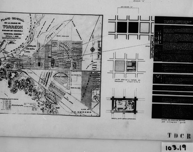
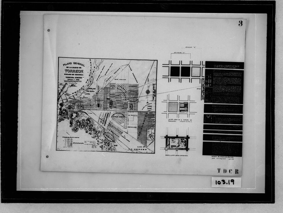
This image appears to be a black-and-white reproduction of a planning or architectural document. On the left side, there is a detailed map titled "PLANO GENERAL DE LA CIUDAD DE TORREON", referencing the city of Torreón in the state of Coahuila, Mexico. The map shows various labeled areas, streets, plots, and structures in the city, along with directional markers and annotations.
On the right side of the image, there are grid-based designs and diagrams, possibly related to urban planning or construction layouts. Additionally, there is a vertical block of text, which might provide further details or explanations regarding urban planning specifications.
The framed image has a number "3" written in the top-right corner, and in the bottom-right corner, there are additional identifiers, including "103.19" and "TDCR."
Created by gpt-4o-2024-08-06 on 2025-06-10
The image shows a framed plan or map document that appears to relate to the city of Torreón, located in the State of Coahuila, Mexico. The main part of the plan is labeled "Plano General de la Ciudad de Torreón" and includes detailed diagrams and layouts of city blocks, streets, and infrastructure. The map shows various sections of the city and includes a grid-like pattern typical of urban planning drawings. There are annotations and labels throughout the map, some of which are in Spanish. On the right side of the document, there are additional schematic diagrams and blocks of text that likely provide further details or explanations about the urban planning or infrastructure depicted. The entire sheet containing these diagrams is placed within a protective glass frame. The label or code "103.19" is visible in the lower right corner just outside the framed area, possibly indicating an archival or catalog reference.
Anthropic Claude
Created by anthropic.claude-3-haiku-20240307-v1:0 on 2025-06-13
The image appears to be a black and white map of the city of Torreón, Mexico. The map shows the general layout of the city, including major streets, neighborhoods, and landmarks. There are also some additional diagrams and text providing additional details about the city. The image has a formal, technical appearance, suggesting it is likely an official or historical city map.
Created by us.anthropic.claude-3-5-sonnet-20241022-v2:0 on 2025-06-13
This image appears to be a historical map or city plan. It shows what looks like a "Plano Catastral" (cadastral plan) of what might be a town or city. The map is displayed in what seems to be an archival or museum setting, mounted on a dark background with reference numbers visible (103.19). The map shows street layouts, blocks, and various geographical features. It appears to be in black and white or grayscale, and includes some text and annotations, though the details are not entirely clear in this reproduction. The document has a professional, technical appearance typical of municipal or urban planning documents from an earlier era.
Meta Llama
Created by us.meta.llama3-2-11b-instruct-v1:0 on 2025-06-10
The image is a black-and-white photograph of a framed document, likely a blueprint or architectural plan. The document is placed on a white background and features a black frame.
- Document
- The document is a blueprint or architectural plan, possibly for a building or structure.
- It has a title at the top that reads "PLANO GENERAL" in Spanish, which translates to "General Plan".
- The document includes various symbols, lines, and markings that appear to represent different elements of the plan, such as buildings, roads, and utilities.
- There are also several numbers and letters scattered throughout the document, which may represent measurements, coordinates, or other relevant information.
- Frame
- The frame is made of dark wood and has a simple design.
- It is rectangular in shape and has a flat top and bottom.
- The frame is slightly wider than the document, leaving a small border around the edges.
- Background
- The background of the image is a plain white surface.
- There are no other objects or features visible in the background.
In summary, the image shows a framed document that appears to be a blueprint or architectural plan for a building or structure. The document includes various symbols, lines, and markings that represent different elements of the plan, and is placed on a plain white background within a simple dark wood frame.
Created by us.meta.llama3-2-90b-instruct-v1:0 on 2025-06-10
This image appears to be a scanned document featuring a map and architectural plans. The map, situated on the left side of the page, is titled "PLANO GENERAL DE LA CIUDAD DE TORREON" and includes various labels and markings. Adjacent to the map are several architectural plans, which seem to depict different sections or buildings within the city.
The document is presented in black and white, with a white background and a black border around the edges. A small label in the bottom-right corner reads "103.19," suggesting that this may be a reference number or identifier for the document. Overall, the image suggests that it is a historical or archival document related to urban planning or architecture in the city of Torreón.
Amazon Nova
Created by amazon.nova-lite-v1:0 on 2025-06-09
The image shows a black-and-white photograph of a document or a map. The document appears to be a map of Torreon, a city in Mexico, with the title "Plano General de la Ciudad de Torreon Estado de Coahuila." The map is divided into sections, with the upper section showing the city's layout and the lower section providing additional information and details. The map is surrounded by a black border, and the text and numbers are in white. The image has a slightly blurry quality, which may be due to the age or quality of the photograph.
Created by amazon.nova-pro-v1:0 on 2025-06-09
The image is a black and white photograph of a framed document with a black border. The document appears to be a map of the General Plan of Torreón, with various sections and annotations. The map is divided into several sections, with different areas labeled and marked. The top right corner of the map has a number "3" written in black ink. The bottom right corner of the map has a label "TDCR 103.19".
Google Gemini
Created by gemini-2.0-flash-lite on 2025-05-05
The image is a black-and-white photograph of a framed document. The document appears to be a detailed map or architectural plan, possibly of a city or urban area, specifically mentioning "Torreon" and the "Estado de Coahuila." It has several parts, including a main map with labels and a section with other diagrams and text.
The framed document itself is mounted on a white backing and is protected by a clear material. There are a few punched holes, suggesting it might be a scanned or a print. On the lower right, there's an identification with "TDCR" and "103.19". The frame is a simple black border that encases the entire image.
Created by gemini-2.0-flash on 2025-05-05
The image shows a black-and-white photograph of a framed document. The document is a "Plano General De La Ciudad De Torreon," labeled as the "Tercera Edicion" (Third Edition). It includes a detailed map of Torreon, along with smaller diagrams illustrating urban planning concepts, such as the location of public gardens and temples, and arrangements of public squares with gardens. The document is framed in a black frame, and in the lower right corner, "TDCR 103.19" is visible. A "3" is in the upper right corner.
Mistral Pixtral
Created by us.mistral.pixtral-large-2502-v1:0 on 2025-06-03
The image depicts a framed architectural plan labeled "Plano General de la Ciudad de Torreón, Estado de Coahuila" (General Plan of the City of Torreón, State of Coahuila). The plan appears to be a detailed layout of the city, showing various buildings, streets, and landmarks. The plan includes several sections:
Main Plan: The central part of the image shows a detailed map of the city, including streets, buildings, and possibly significant landmarks. The map is labeled with various locations and features.
Inset Plans: To the right of the main plan, there are smaller inset plans that provide more detailed views of specific areas or structures within the city. These insets likely focus on important buildings or zones.
Textual Information: On the far right, there is a block of text that likely provides additional information about the plan, such as descriptions, notes, or explanations of the various elements depicted in the map.
Labels and Annotations: The plan includes various labels and annotations that identify specific locations, streets, and buildings. These labels help to orient the viewer and provide context for the different parts of the city.
Frame and Identification: The plan is framed, and there is a label at the bottom right corner that reads "T D C R 103.19," which could be an identification or catalog number for the plan.
Overall, the image provides a comprehensive view of the city of Torreón, detailing its urban layout and significant features.
Qwen
Created by Qwen/Qwen2.5-VL-7B-Instruct on 2025-07-27
The image shows a document that appears to be a city plan for Torreón, located in the state of Coahuila, Mexico. The document is labeled "Plano General de la Ciudad de Torreón" which translates to "General Plan of the City of Torreón." It includes a detailed map of the city, showing streets, buildings, and other urban features. On the right side of the document, there are several diagrams and text descriptions, possibly detailing specific areas, plans for construction, or other urban planning aspects. The document is numbered "3," and there are additional codes and numbers at the bottom right, "TDCR" and "103.19," which may indicate a reference or cataloging system. The overall appearance suggests it is a historical or archival document related to urban planning and city development.
Created by Qwen/Qwen2.5-VL-72B-Instruct on 2025-07-27
This image shows a historical document featuring the general plan of the city of Torreón, located in the state of Coahuila, Mexico. The document includes a detailed map of the city, highlighting various streets, buildings, and landmarks. The map is labeled "Plano General de la Ciudad de Torreón" and includes annotations and symbols that represent different areas and features of the city.
To the right of the map, there is a section with text and diagrams, likely providing additional information about the city's layout, infrastructure, and planning. The document is marked with the number "3" in the top right corner and has a reference code "103.19" at the bottom. The acronym "TDCR" is also present at the bottom right corner of the document. The overall appearance suggests that this is an archival or historical document, possibly used for urban planning or administrative purposes.
Text analysis
Amazon