Machine Generated Data
Tags
Color Analysis
Feature analysis
Amazon
| Monitor | 86.9% | |
Categories
Imagga
| text visuals | 39.9% | |
| interior objects | 27.2% | |
| streetview architecture | 17.1% | |
| paintings art | 8% | |
| pets animals | 3.4% | |
| cars vehicles | 2.6% | |
Captions
Microsoft
created on 2022-06-04
| a screen shot of a blackboard | 88.4% | |
| a blackboard near a monitor | 74.9% | |
| a close up of a blackboard | 74.8% | |
OpenAI GPT
Created by gpt-4 on 2024-12-07
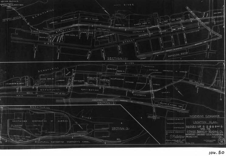
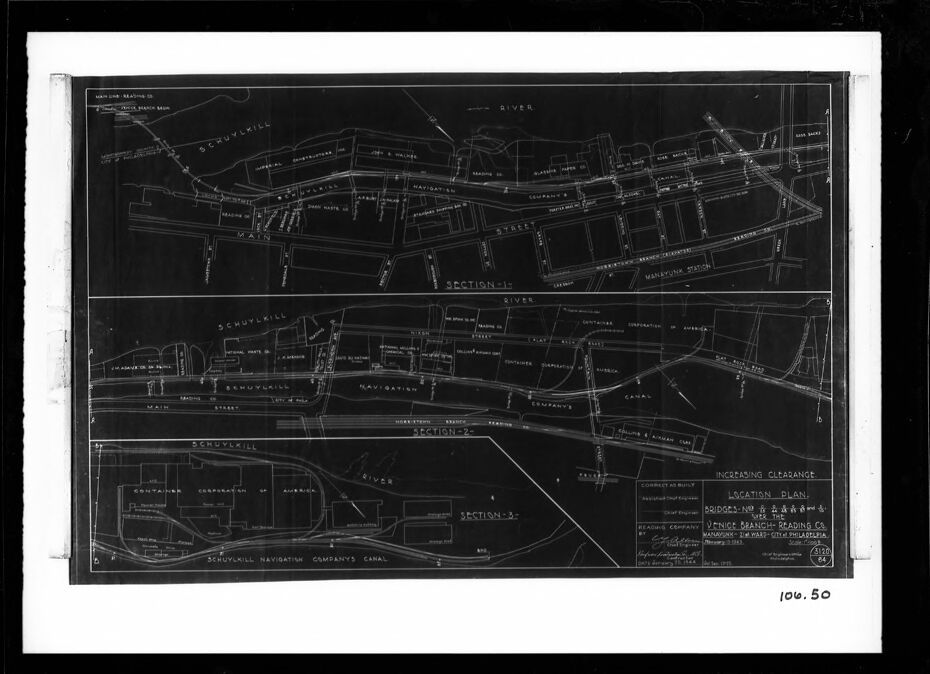
This image is a photograph of a blueprint. The blueprint is presented in a format where white lines and text are set against a dark background, which is characteristic of a negative image of a blueprint. It appears to be a detailed technical drawing or plan of a system of waterways or canals, perhaps for navigation or drainage purposes. On the blueprint, there are labels such as "MAIN," "RIVER," and "CANAL," which suggest the features drawn are related to water infrastructure. Different sections are labeled as "SECTION 1," "SECTION 2," and "SECTION 3." The words "SCHUYLKILL NAVIGATION COMPANY'S CANAL" are clearly visible, indicating that this blueprint is related to the Schuylkill Navigation Company, possibly detailing parts of a canal system under their purview or plans for construction or modification. Additional labels and notations on the blueprint likely provide specific instructions, dimensions, or other technical details necessary for understanding or building the features displayed. There is text at the bottom right corner, but it's not readable in this image. There are some handwritten notes such as "INCREASING CLEARANGE" and other partially legible comments suggesting modifications or specifications. This type of blueprint would be used by engineers, architects, or city planners for the design, maintenance, and operation of waterway systems. The framing of the picture indicates that the blueprint photograph is mounted for display or preservation.
Created by gpt-4o-2024-05-13 on 2024-12-07
The image is a detailed architectural or engineering blueprint or plan labeled "Bridges No. 1, 2 & 3 Over Branch of Reading Co. Near East Main St., Norristown, PA." It consists of three sections or views. - The top portion, labeled "Section 1," shows a map with various streets, buildings, and infrastructure, including the Schuylkill River and Main Street. Specific buildings and structures like the Freight House, Reading Company Shops, and other named buildings are indicated, with notes on measurements and other details. - The middle portion, labeled "Section 2," provides a similar view with different segments of the area, including elements that appear to relate to railway lines and adjacent buildings. Streets such as Markley Street, and other infrastructure elements like the Schuylkill Navigation Company's Canal, are noted. - The bottom section shows further divided details, labeled "Section 3," with the River, Canal, and Main Street running horizontally across with other infrastructural details. The title block or legend is located at the bottom right and contains various notes, a scale (1"=40'), and names of the responsible engineers or company offices, indicating it's prepared by the company's engineering department. The blueprint is framed in black and white, printed in white ink on a dark background, typical of blueprints from the early 20th century.
Anthropic Claude
Created by claude-3-haiku-20240307 on 2024-12-07
The image appears to be a black and white map or layout plan. It shows a detailed layout of a city or town, with various streets, buildings, and landmarks clearly marked and labeled. The map appears to be divided into sections, with labels indicating different areas or sections of the city. There are no human figures visible in the image.
Created by claude-3-5-sonnet-20241022 on 2024-12-07
This appears to be a historical engineering or architectural blueprint showing a location plan along the Schuylkill River in what seems to be Philadelphia. The drawing is in white lines on a dark background, typical of old blueprint style. It shows multiple sections of an area including the Schuylkill Navigation Company's Canal, Main Street, and various other street layouts and property boundaries. The plan is divided into three sections labeled "Section 1-2-3" and appears to be documenting bridges or clearances along the river and canal system. Based on the title block visible in the lower right corner, this seems to be related to the Venice Mabardi Trading Co., though the exact date isn't clearly visible in this image. The drawing provides a detailed overhead view of the infrastructure and property divisions along this section of the river.
Meta Llama
Created by us.meta.llama3-2-11b-instruct-v1:0 on 2024-12-07
The image presents a black-and-white blueprint or map, showcasing a detailed plan of a location. The map is divided into two sections, each featuring a unique layout and design. **Section 1:** * **Layout:** The top section of the map appears to be a street map, with various roads and buildings labeled. * **Features:** Several notable features are visible, including a river, a canal, and a railroad track. * **Labels:** The map includes labels for different locations, such as "Schuylkill River" and "Schuylkill Navigation Company's Canal." **Section 2:** * **Layout:** The bottom section of the map seems to be a more detailed plan of a specific area, possibly a industrial or commercial zone. * **Features:** This section includes additional details, such as buildings, warehouses, and other structures. * **Labels:** The map features labels for specific locations, including "Schuylkill River" and "Schuylkill Navigation Company's Canal." **Additional Details:** * **Scale:** The map includes a scale at the bottom, indicating that it is drawn to a specific measurement. * **Date:** The map bears a date, although it is not legible in the provided image. * **Signature:** A signature is visible in the bottom-right corner, but it is unclear who signed the map. **Overall:** * The map provides a comprehensive view of the location, highlighting its layout, features, and notable locations. * The inclusion of a scale and date suggests that the map was created for a specific purpose, possibly for planning or development purposes. * The signature in the corner adds an element of authenticity to the map, indicating that it was created by a qualified individual or organization.
Created by us.meta.llama3-2-90b-instruct-v1:0 on 2024-12-07
This image presents a black and white map, likely a blueprint or technical drawing, featuring a detailed layout of roads, rivers, and other geographical features. The map is divided into three sections, each labeled with a number and title, such as "SECTION - 1" and "SECTION - 2." The map also includes various symbols, markings, and notations, which appear to be related to engineering or architectural plans. The map is presented on a white background, surrounded by a black border, and features a handwritten notation in the bottom-right corner that reads "106.50." This suggests that the map may be part of a larger collection or archive, and the notation could be a reference number or identifier. Overall, the image provides a clear and detailed view of the map, allowing the viewer to examine the various features and symbols depicted. The use of a black and white color scheme gives the image a classic and timeless feel, while the handwritten notation adds a touch of human touch to the otherwise technical drawing.
Amazon Nova
Created by amazon.nova-lite-v1:0 on 2025-02-25
The image is a technical drawing of a railway layout, specifically focusing on a section of the Schuylkill Navigation Company's canal system. The drawing is in black and white and appears to be an engineering blueprint. The drawing is divided into three sections, each labeled as "SECTION-1," "SECTION-2," and "SECTION-3." The sections show various elements of the canal system, including the canal itself, bridges, and the surrounding infrastructure. The drawing also includes labels and notes, such as "INCREASING CLEARANCE" and "LOCATION PLAN." The drawing is dated "100.50," which likely refers to the year 1850. The image is framed in a black border, giving it a professional and technical appearance.
Created by amazon.nova-pro-v1:0 on 2025-02-25
The image is a black and white photograph of a document that appears to be a technical drawing or a map. The document is divided into three horizontal sections, each containing detailed diagrams and text. The upper section features a network of lines and labels, possibly representing a layout or plan. The middle section contains similar diagrams with additional annotations and labels. The lower section includes a larger diagram with more detailed annotations and labels, along with a title and a reference number. The document is framed by a black border, giving it a formal and official appearance.
Text analysis
Amazon