Machine Generated Data
Tags
Color Analysis
Feature analysis
Amazon
| Monitor | 55.3% | |
Categories
Imagga
| text visuals | 42.5% | |
| interior objects | 40% | |
| paintings art | 15.2% | |
Captions
Microsoft
created on 2022-06-04
| an old photo of a person | 50.4% | |
| an old photo of a room | 50.3% | |
| a person sitting in a room | 38.1% | |
Azure OpenAI
Created by gpt-4 on 2024-12-07
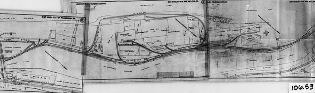
This black and white image displays what appears to be an engineering or architectural blueprint or plan that is placed within a protective frame or holder. The drawing seems to be folded and winds across the frame's length. It includes scaled layouts with various lines, possibly indicating walls, boundaries, or structures, and might include notations, measurements, or symbols that are commonly used in technical plans for construction or mechanical objects. The visibility of the specific details in the plan is limited due to the folding and the distance at which the picture is taken. There seems to be a numbering or coding in the corner of the frame, reading "106.53," which could refer to a cataloging system or reference number for the plan. The image overall has a historical look, suggesting it might be an archival document or an exhibit piece.
Created by gpt-4o-2024-05-13 on 2024-12-07
The image shows a black and white photograph of a framed map or technical drawing. The map appears to be an old plan or blueprint, depicting a specific area with roads, railway lines, plots of land, and possibly waterways marked. The drawing looks to be detailed, with various labels and annotations on it. The map seems to have been pieced together from different sections that do not perfectly align, indicating it might be a composite of different parts. The frame around the map is plain and functional, designed more to protect and display the document than to be decorative. In the lower right corner of the frame, there is a label with the numbers "106.53" written on it, possibly indicating an identification number or catalog reference. The map itself is somewhat worn and slightly crinkled in some areas.
Anthropic Claude
Created by claude-3-haiku-20240307 on 2024-12-07
The image appears to be a black and white map or blueprint. The map shows various geographic areas and features, with numerous labeled sections and detailed annotations. There are multiple panels or sections that seem to be connected and show an overall plan or layout of a larger area. The image has a vintage or archival appearance, with the map contained within a black framed border. The number "106.53" is visible in the bottom right corner, likely indicating a reference or identification number for this particular map or diagram.
Created by claude-3-5-sonnet-20241022 on 2024-12-07
This appears to be a black and white photograph of what looks like an old map or survey document. The image shows three connected sections that appear to be plotting out land parcels or property boundaries. The documents are laid out horizontally and appear to be showing a continuous area or route. There's a number visible in the corner that reads "106.53". The maps show various divided sections with lines and boundaries marked, possibly representing property lines, roads, or geographical features. The image is framed with a dark border and appears to be mounted or displayed against a light background.
Meta Llama
Created by us.meta.llama3-2-11b-instruct-v1:0 on 2024-12-07
The image presents a black-and-white photograph of a map, likely created in the early 20th century, showcasing a detailed representation of a river and its surrounding landscape. The map is divided into sections, each containing various symbols, lines, and markings that indicate the location of buildings, roads, and other features. * **Map Sections:** * The map is divided into multiple sections, each with its own unique set of symbols and markings. * The sections are arranged in a way that suggests they are meant to be connected, forming a larger picture of the river and its surroundings. * **Symbols and Markings:** * The map features a variety of symbols and markings, including lines, shapes, and text. * Some of the symbols appear to represent buildings, roads, and other man-made structures, while others may indicate natural features such as rivers, forests, and mountains. * The text on the map is likely used to label different locations and provide additional information about the area. * **River and Surroundings:** * The map focuses on a specific section of the river, which is depicted as a winding course through the landscape. * The surrounding area is shown to be relatively flat, with some hills and valleys visible in the distance. * The map suggests that the river plays an important role in the local ecosystem, with several tributaries and waterways branching off from the main course. * **Overall:** * The map provides a detailed and informative view of the river and its surroundings. * It appears to be a valuable resource for anyone interested in learning more about the area, whether for historical, recreational, or practical purposes. In summary, the image presents a detailed and informative map of a river and its surroundings, likely created in the early 20th century. The map features a variety of symbols and markings that indicate the location of buildings, roads, and other features, and provides a valuable resource for anyone interested in learning more about the area.
Created by us.meta.llama3-2-90b-instruct-v1:0 on 2024-12-07
The image presents a black-and-white photograph of a map, which appears to be a historical or archival document. The map is displayed on a white background within a black frame, with two metal clips holding it in place. The map itself is a detailed illustration of a city or town, featuring various buildings, roads, and other geographical features. In the bottom-right corner of the map, a small handwritten note reads "106.53," suggesting that this may be an identification number or code for the map. The overall appearance of the image suggests that it is a scanned or digitized version of an original physical map, possibly from an archive or collection.
Text analysis
Amazon