Machine Generated Data
Tags
Color Analysis
Feature analysis
Amazon
Clarifai

Clarifai
| Picture frame | 99.3% | |


Categories
Imagga
created on 2022-06-04
| interior objects | 86% | |
| streetview architecture | 6.9% | |
| paintings art | 5.8% | |
Captions
Microsoft
created by unknown on 2022-06-04
| a screen shot of a computer | 77.2% | |
| a screen shot of a computer monitor | 56.4% | |
| a close up of a screen | 56.3% | |
Clarifai
No captions written
Salesforce
Created by general-english-image-caption-blip on 2025-05-21
a photograph of a map of a city with a map of the area
Created by general-english-image-caption-blip-2 on 2025-07-02
plan of the new city hall, new york city, ny
OpenAI GPT
Created by gpt-4 on 2024-12-06
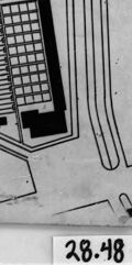
This image appears to be a photograph of an architectural floor plan or a map showing the layout of a building or complex. The plan is highly detailed and includes numerous individual rooms, sections, and possible pathways. There are labels for different areas, though the text is not clear enough to read in this view. At the lower left corner of the actual drawing (not the surrounding border), there is a directional indicator (a north arrow) and what appears to be a scale bar, suggesting the drawing is to scale. Along the right edge of the photograph, you can note what seems to be a legend or key, often used in architectural drawings to explain symbols or notation.
In the bottom-right corner of the photograph, there is a label or tag with the numbers "28.48," which might be a reference number for the drawing or photograph archive. The image of the plan is surrounded by a white border and it's encased in a protective casing or frame with black borders, suggesting that the photograph may have been taken while the plan is mounted or on display. The overall condition and style indicate the plan may be historical or from a significant project.
Created by gpt-4o-2024-05-13 on 2024-12-06
The image depicts a black-and-white floor plan or site map. The layout appears to be of a residential or industrial complex with several long, parallel buildings and wider structures identified as "KITCHEN" and "LAVATORIA" (perhaps, lavatories). The plan includes tertiary streets or walkways separating the structures. A main thoroughfare or access road runs across the site and meets secondary pathways. Additionally, a small segment in the lower left corner of the plan appears to be an inset or magnified detail of a specific area of the site. The map is oriented with an arrow pointing upwards, possibly indicating north. The number "28.48" is displayed in the lower right corner.
The plan is framed within a dark border, and there is a white backdrop surrounding the framed plan, suggesting that it might be a photograph or a scan of a physical map.
Anthropic Claude
Created by us.anthropic.claude-3-5-sonnet-20241022-v2:0 on 2025-06-25
This image appears to be an architectural or site plan drawing, shown in black and white. It looks like a layout or blueprint of what could be a cemetery, prison, or similar institutional facility. The plan shows a systematic arrangement of rectangular plots or units organized in parallel rows. There's a large arrow pointing upward on the drawing, likely indicating north direction. The overall shape of the site is somewhat irregular or trapezoidal, and the drawing includes various markings and lines that could represent pathways, boundaries, or other structural elements. The image appears to be an old document, possibly a historical planning document, as evidenced by its grainy, vintage appearance and the number "20.10" visible in the corner.
Created by claude-3-haiku-20240307 on 2024-12-06
The image appears to be an architectural or urban planning blueprint or diagram. It shows a grid-like layout with various geometric shapes and labels, suggesting it is a map or diagram of a building or neighborhood layout. The image is black and white, and has a dated, archival appearance, indicating it is likely an old document or technical drawing.
Created by claude-3-5-sonnet-20241022 on 2024-12-06
This appears to be an architectural or site plan drawing, likely from an aerial view. The image shows a black and white layout diagram of what seems to be a camp or institutional facility. The plan is divided into multiple rectangular sections arranged in a grid pattern, with several long parallel buildings or barracks arranged in rows. There are also larger rectangular structures indicated on the right side of the plan. The entire complex appears to be situated within a triangular or wedge-shaped plot of land, with roads or boundaries indicated along the edges. The drawing has a technical, blueprint-like quality typical of architectural planning documents, and includes some reference numbers (28.48) visible at the bottom right corner.
Meta Llama
Created by us.meta.llama3-2-11b-instruct-v1:0 on 2024-12-06
The image presents a black-and-white photograph of a blueprint or architectural drawing, showcasing a building's floor plan. The drawing is framed by a thick black border, with a white background and a gray border around it.
Key Features:
- Floor Plan: The drawing depicts a building with multiple floors, featuring various rooms and corridors.
- Labels: The drawing includes labels and symbols, likely indicating different areas or features of the building.
- Scale: A scale is visible in the bottom-right corner, suggesting that the drawing is to scale.
- Date: A handwritten date, "28.48," is visible in the bottom-right corner, although the exact date is unclear.
- Background: The background of the image appears to be a plain white or light-colored surface, possibly a table or wall.
Overall Impression:
The image suggests that the blueprint or architectural drawing is an important document, possibly related to a construction project or renovation. The presence of a scale and labels implies that the drawing is intended for use in a professional or technical context.
Created by us.meta.llama3-2-90b-instruct-v1:0 on 2024-12-06
The image depicts a black-and-white architectural drawing of a building's floor plan, set against a white background and framed in black. The drawing is oriented at an angle, with the top-left corner pointing towards the upper right side of the image.
In the bottom-right corner of the frame, a small white label bears the handwritten notation "28-48" in black ink. The overall appearance of the image suggests that it may be a historical or archival document, possibly from the early 20th century.
Amazon Nova
Created by amazon.nova-lite-v1:0 on 2025-02-25
The image shows a black-and-white map of a building or facility. The map is placed in a frame with a black border and a white background. The map appears to be a floor plan or layout of the building, showing the different rooms, corridors, and other areas. The map is labeled with numbers and letters, possibly indicating specific rooms or areas. The map is divided into sections, with each section showing a different part of the building. The map also includes a scale at the bottom, indicating the size of the building and the distance between different areas. Overall, the image appears to be a detailed and informative map of a building or facility.
Created by amazon.nova-pro-v1:0 on 2025-02-25
The image is a black-and-white photograph of an architectural drawing or plan. The drawing depicts a layout of a residential area, possibly an apartment complex or housing development. The plan shows a grid-like arrangement of rectangular blocks, which likely represent individual units or buildings. The blocks are organized in rows and columns, with some blocks being larger than others, suggesting different sizes or types of units. The drawing also includes a scale and a reference number "28-48" in the bottom right corner, which might indicate the specific plan or version of the drawing.
Google Gemini
Created by gemini-2.0-flash-lite on 2025-04-28
Here's a description of the image:
The image is a black and white photograph of a blueprint or architectural plan. It's framed in a black rectangular border. The plan itself appears to be on a slightly off-white or aged paper.
Here's what I can see from the plan:
- Layout: The plan seems to depict a complex layout, possibly a camp, with numerous rows of rectangular structures (likely buildings or barracks) organized in parallel lines.
- Details: There are some text labels on the plan, though they are partially obscured or too small to read clearly.
- Direction: There is a large arrow indicating a direction.
- Scale: The presence of multiple small rectangular structures and some other buildings may indicate there is a sense of scale to the plan.
- Overall: The image has a sense of history and detail, a testament to a past project.
Created by gemini-2.0-flash on 2025-04-28
The image appears to be a black and white photograph of an architectural or city planning diagram. The diagram is presented on a square piece of paper, which is slightly askew, and it’s mounted on a white surface, all of which is framed by a black border.
The diagram itself depicts a layout of what seems to be an area with structured rows of buildings or plots, with a network of streets or pathways running between them. The overall shape of the planned area is somewhat trapezoidal.
There are several long, parallel lines suggesting rows of structures, possibly housing or storage units, interspersed with black rectangles that could be buildings or markers. Some larger rectangular shapes are also visible, possibly representing larger facilities. Text labels are also visible within the diagram, though they are difficult to read.
At the bottom left corner of the diagram, there is a small sketch of what could be a different layout or a smaller area, perhaps detailing a specific section of the larger plan. Additionally, there is an arrow indicating a direction, presumably north.
In the lower right corner of the photograph, outside of the mounted diagram, there is a handwritten number "28.48".
The image has a slightly dated or archival quality, which is further emphasized by the framing and the black and white tones.
Mistral Pixtral
Created by us.mistral.pixtral-large-2502-v1:0 on 2025-04-28
The image is a black-and-white photograph of a framed architectural plan or blueprint. The plan appears to be a detailed layout of a large building or complex, possibly a warehouse, factory, or a similar industrial structure. Here are some notable features:
Layout and Structure:
- The plan shows a rectangular building with a series of parallel, elongated sections or bays.
- There are multiple rows of these sections, indicating a repetitive structural design, which is common in industrial buildings.
- The layout includes several labeled areas, such as "Bürogebäude" (office building) and "Lagerhalle" (storage hall), suggesting different functional zones within the building.
Details and Annotations:
- The plan includes various annotations and symbols, likely indicating specific features or instructions for construction.
- There are smaller insets or detailed views, possibly showing specific elements like structural supports or mechanical systems.
- The plan is numbered "28.48" in the bottom right corner, which might be a reference or identification number.
Orientation:
- There is a north arrow in the bottom left corner, indicating the orientation of the plan.
- The arrow points upwards, suggesting that the top of the plan is oriented towards the north.
Framing:
- The plan is framed with a thick black border, giving it a formal and preserved appearance.
- The framing suggests that this plan might be of historical or significant value.
Overall, the image depicts a detailed and meticulously drawn architectural plan of an industrial building, likely from an earlier period given the style and presentation.
Qwen
Created by Qwen/Qwen2.5-VL-7B-Instruct on 2025-07-25
The image appears to be a black and white architectural or urban planning drawing, possibly a layout or plan for a complex of buildings or a large piece of land. The drawing is detailed, with various sections and labeled areas, suggesting it may be a blueprint or site plan. The top right corner of the document is slightly torn, and there is an arrow pointing upwards on the left side, which could indicate the direction of the layout or a reference for orientation. The bottom right corner of the document is marked with the numbers "28-48," which might be an index or catalog number. The overall style and detail suggest that this is a technical drawing used for planning or construction purposes.
Created by Qwen/Qwen2.5-VL-72B-Instruct on 2025-07-25
This image appears to be a black and white floor plan or architectural layout of a facility, likely a prison or similar institutional structure. The plan shows a grid-like arrangement of cells or rooms arranged in rows and columns. There are several labeled areas, though the text is not entirely clear. There is an arrow indicating the direction of north, and a small section in the lower left corner that seems to be a separate area connected to the main structure. The image is numbered "28.48" in the bottom right corner. The edges of the paper are slightly worn, suggesting it might be an older document.
Text analysis
Amazon