Machine Generated Data
Tags
Color Analysis
Feature analysis
Amazon
Clarifai

Clarifai
| Picture frame | 99.5% | |
Categories
Imagga
created on 2022-06-04
| text visuals | 99.7% | |
Captions
Microsoft
created by unknown on 2022-06-04
| a screen shot of a computer | 75.2% | |
| a flat screen monitor | 54.8% | |
| a screen shot of a computer monitor | 52.2% | |
Clarifai
No captions written
Salesforce
Created by general-english-image-caption-blip on 2025-05-21
a photograph of a drawing of a plan for a house
Created by general-english-image-caption-blip-2 on 2025-07-02
a black and white photo of a plan for a building
OpenAI GPT
Created by gpt-4 on 2024-12-06
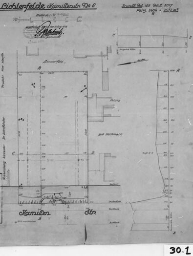
The image shows a black and white photograph of a framed document, which appears to be a technical drawing or architectural floor plan. The document includes a title at the top and various annotations, measurements, and a detailed layout with designated rooms or areas. The drawing displays various geometric shapes that represent the structural and architectural elements of a building. A grid or scale may be present for reference. Texts and numbers within the drawing likely indicate dimensions and specifications relevant to the construction or layout of the structure.
There are specific notations and words in what appears to be German, suggesting that this document might be related to a building or architectural project in a German-speaking region. Due to the nature of the photograph, image quality, and lighting, it's challenging to read the finer details, such as smaller annotations or the exact content of the title at the top.
The drawing is mounted or laid upon a lighter-colored background, and the frame surrounding the document is simple and black, contrasting with the white mount and the tone of the document itself. On the bottom right corner, there is a label or tag with the number "30.1" which could be an inventory number, accession number, or another form of classification identifier.
Created by gpt-4o-2024-05-13 on 2024-12-06
The image shows a framed architectural drawing or blueprint. The drawing appears to be of a floor plan or a layout of a building, possibly residential given the detailed room and structural annotations. The drawing is labeled "Lichterfelde" and "Komiliano," among other details in another language, suggesting it is from a German-speaking region.
The drawing includes various annotations and measurements, indicating dimensions and possibly features of the building. There is meticulous handwriting and several symbols representing different parts of the building's structure. A small segment in the bottom left corner appears to show a cross-section or an additional component of the building.
The framing and presentation suggest that this might be an archived or historically valuable document. The label "30.1" affixed to the frame might be an archival reference or an exhibit number.
Anthropic Claude
Created by us.anthropic.claude-3-5-sonnet-20241022-v2:0 on 2025-06-25
This appears to be an old architectural or technical drawing, likely from Germany based on the German text "Lichterfelder" visible at the top. It's a black and white floor plan or site plan drawing showing various measurements and layout details. The drawing is mounted or framed with a dark border and appears to be labeled "30.1" in the bottom right corner. The document seems to be a historical record or archive piece, given its aged appearance and traditional drafting style. The drawing includes various lines, dimensions, and annotations typical of architectural or engineering documentation from what appears to be the early-to-mid 20th century.
Created by claude-3-haiku-20240307 on 2024-12-06
The image appears to be a black and white engineering or architectural plan or diagram. It shows a layout or floor plan, with various lines, labels, and measurements indicating different structures or features. The title at the top indicates this is a "Liechtefelde Familienblatt Nr. 6" (Liechtefelde Family Sheet No. 6). The overall impression is of a technical, detailed document rather than a visual image.
Created by claude-3-5-sonnet-20241022 on 2024-12-06
This appears to be an architectural or technical drawing, labeled "Richtersfeld" at the top. It's a black and white floor plan or site plan drawing showing various measurements and layout details. The drawing includes German text and appears to be a historical document, given its aged appearance and style. The image shows various rooms or sections marked with lines and measurements, and includes what appears to be some form of legend or information box in the lower left corner. The document is mounted or framed against a darker background and has the number "30.1" visible in the bottom right corner.
Meta Llama
Created by us.meta.llama3-2-11b-instruct-v1:0 on 2024-12-06
The image is a black-and-white photograph of an old blueprint or architectural drawing, with a black border and a white background.
The blueprint is centered in the image and appears to be hand-drawn. It features a mix of handwritten and printed text, as well as various symbols and markings. The text is written in German, and it appears to be a technical drawing or plan for a building or structure. The drawing includes measurements, labels, and other details that suggest it is a detailed and precise representation of a specific architectural design.
In the bottom-right corner of the image, there is a small white label with the number "30.1" handwritten in black ink. This label may indicate that the blueprint is part of a larger collection or series of documents, and the number "30.1" could be a reference or identifier for the specific drawing.
Overall, the image provides a glimpse into the past, showcasing an old blueprint or architectural drawing that may have been used for construction or design purposes. The level of detail and precision in the drawing suggests that it was created by a skilled draftsman or architect, and the use of German text adds an air of authenticity to the image.
Created by us.meta.llama3-2-90b-instruct-v1:0 on 2024-12-06
The image depicts a black-and-white architectural plan, likely for a building or structure. The plan is presented on a light gray background with a white border and a black frame. It features various lines, symbols, and text in German, which may indicate that it is an original document from the early 20th century.
In the bottom-right corner of the image, there is a small white rectangle with the number "30.1" written in black ink. This suggests that the image may be part of a larger collection or archive of architectural plans.
Overall, the image provides a detailed view of an architectural plan from the early 20th century, offering insight into the design and construction of buildings during that time period.
Amazon Nova
Created by amazon.nova-pro-v1:0 on 2025-03-01
The image is a monochromatic document, likely a historical architectural blueprint or plan. It is framed by a black border, and the document itself is presented on a white background. The document appears to be a technical drawing, possibly related to construction or engineering.
The top section of the document contains text in a foreign language, which seems to be German. The text includes terms like "Pichlerfelde" and "Kaminlen," which could be place names or technical terms. There are also numbers and what appears to be a date, "1908," suggesting the document is from the early 20th century.
Below the text, there is a detailed architectural drawing. The drawing includes a floor plan with various rooms and sections labeled. The labels include terms like "Kaminlen" and "Str," which might refer to specific parts of the structure or rooms. The drawing shows a layout with multiple rooms, corridors, and possibly a staircase.
The right side of the drawing includes a vertical scale, indicating measurements in meters. There are also annotations and dimensions marked on the drawing, which are crucial for understanding the spatial relationships and dimensions of the structure.
The bottom of the document features a series of numbers and letters, possibly referencing specific parts of the drawing or providing additional information about the structure. The number "30.1" is prominently displayed at the bottom right corner of the document.
Overall, the document appears to be a detailed architectural plan, likely used for construction or renovation purposes. The presence of measurements, labels, and a scale indicates that it is a technical document intended for professionals in the field of architecture or construction.
Created by amazon.nova-lite-v1:0 on 2025-03-01
The image appears to be a historical document or map, possibly from the late 19th or early 20th century. It contains a combination of text and a map or diagram. Here is a detailed description of the image:
The image is framed with a black border, giving it a vintage or archival look.
The text in the top left corner reads "Pichleffelde Hamiltenschen 926," which could be the name of a location or property.
Below the text, there is a table with columns and rows, possibly containing numerical data or measurements. The table has headings such as "Haltrahs," "Part 4606," and "1577m2," which could represent different categories of information.
To the right of the table, there is a map or diagram. The map appears to be a simplified representation of a landscape or terrain, with various lines, shapes, and labels. Some of the labels include "Stra," "Hamilten," and "30.1," which could be the names of roads, locations, or measurements.
The map or diagram is accompanied by a scale, which is likely located in the lower right corner of the image. The scale is not clearly visible in the provided image, but it is typically used to indicate the relationship between the map's dimensions and the actual distances or areas it represents.
The overall tone of the image is monochromatic, with shades of gray and black, which is common for historical documents and maps.
In summary, the image appears to be a historical document or map from the late 19th or early 20th century, containing a combination of text, a table with numerical data, and a map or diagram with various labels and a scale. The specific purpose or context of the document is not clear from the provided image, but it could be related to land ownership, property measurements, or geographic information.
Google Gemini
Created by gemini-2.0-flash-lite on 2025-04-28
Here is a description of the image:
The image showcases a detailed architectural or engineering drawing, likely a blueprint or plan, framed and preserved. The drawing itself is on aged paper, indicating its historical significance. It features a series of lines, measurements, and annotations, suggesting a layout or design. The title at the top reads "Lichterfelde Hamillesstr. 928 6," and other text, possibly including dates and dimensions, further enriches the drawing's context. The meticulous detail suggests this plan was created for a specific building or project. The frame, a classic black with a white border, enhances the presentation, emphasizing the drawing as a significant document.
Created by gemini-2.0-flash on 2025-04-28
The image shows a framed black and white photograph of a technical drawing or blueprint. The drawing, titled "Lichterfelde Hamillesstr. 928 6," appears to be a plan of a property or area, possibly for construction or land surveying purposes.
The drawing includes measurements, annotations in German, and various symbols and lines indicative of technical specifications. The bottom of the drawing is labeled "Kamilles Str." Along with other text: "Wiesenberg" and "bausteller pilwelter groplas." There is also a stamp or signature visible at the top of the drawing. A note in the upper-right corner reads "Grundb od 168 Platt 5017 Pang 3404 1677m²."
In the bottom right corner of the photo, there is a label that reads "30.1".
Mistral Pixtral
Created by us.mistral.pixtral-large-2502-v1:0 on 2025-04-28
The image depicts a framed, historical architectural plan or blueprint. The title at the top of the document reads "Büchlerfelde Kanalisations Dt. 6," which translates to "Büchlerfelde Sewerage Plan No. 6." The plan is dated October 2, 1917, and was created by the engineering firm "H. & E. Gruner." The document appears to be a detailed layout of a sewerage system, showing various elements such as pipes, manholes, and possibly other infrastructure components.
Key features of the plan include:
- A legend or key in the bottom left corner, which likely explains the symbols and lines used in the plan.
- Labels and annotations in German, indicating different parts of the sewerage system.
- Measurements and dimensions, which are crucial for the accurate construction and placement of the sewerage components.
- A signature or stamp of the engineering firm, "H. & E. Gruner," indicating their involvement in the design.
The plan is framed, suggesting it may be preserved for historical or educational purposes. The number "30.1" in the bottom right corner could be an inventory or catalog number.
Qwen
No captions written
Text analysis
Amazon