Machine Generated Data
Tags
Color Analysis
Categories
Imagga
| text visuals | 74.3% | |
| interior objects | 22.4% | |
| streetview architecture | 2.3% | |
Captions
Microsoft
created on 2020-04-26
| a black and white photo of a clock | 80.3% | |
| a black and white photo of a flat screen tv | 70.7% | |
| a clock mounted to the side | 70.6% | |
OpenAI GPT
Created by gpt-4 on 2025-03-06
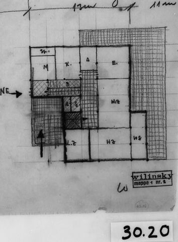
This image displays a photographic reproduction of a hand-drawn architectural floor plan or layout. The plan is drawn on grid paper, suggesting it's drawn to scale. You can see various labeled rooms or spaces arranged in a structured design.
On the drawing, there's an orientation mark indicating the directions North (N) and Northeast (NE). The room labels are not entirely clear, but you can see that each area is outlined, some with hatched patterns, perhaps to indicate various finishes, wall coverings, or open spaces. It's also possible to note measurements written beside the walls, presumably giving the dimensions for the spaces.
A handwritten note at the top part of the drawing reads "sp. gd. zt arm," which is not immediately clear and might be interpreted with additional context. On the bottom right corner, there's a signature or stamp that reads "Willinsky," possibly the name of the architect or drafter, followed by "mappa nr.," which suggests that this drawing is part of a series or collection numbered as a map or plan.
At the bottom center of the image, outside the framed plan, is a label with the number "30.20," likely an archival or exhibit number for cataloging purposes.
Overall, the image is of a framed architectural drawing, presented for review, display, or archival purposes.
Created by gpt-4o-2024-05-13 on 2025-03-06
The image appears to be an architectural or engineering drawing that is photographed and presented in a framed format. It shows a floor plan or site layout with various sections labeled with alphanumeric identifiers, such as "M," "S," "E," "W," and others. The layout is represented on a grid, indicating measurements and spatial relationships between the areas. There is an arrow indicating the north direction ("N") and another arrow pointing to "NE," providing orientation. Additionally, there is a handwritten note at the top of the image, though it is partially cut off and not entirely legible. The bottom right corner contains a label or stamp that says "Wilinsky mappa i nr. 4." At the lower part of the frame, there is a label with the number "30.20" encased within a small box. The overall tone of the photograph is monochrome, suggesting it might be an old or archival document.
Anthropic Claude
Created by claude-3-haiku-20240307 on 2025-01-13
The image appears to be an architectural floor plan or sketch. It shows a grid-like layout with various labeled rooms and spaces. The plan includes rooms marked as "Mr" and "Hr", as well as an arrow pointing to the northeast direction. The image is hand-drawn and includes grid lines, dimensions, and the name "Wilinski" at the bottom. Overall, this seems to be a detailed, technical drawing of a building or residential floor plan.
Created by claude-3-5-sonnet-20241022 on 2025-01-13
This image appears to be an architectural floor plan or sketch. It's a black and white drawing showing a layout of rooms with various markings and notations. The plan appears to be oriented with North indicated by an "N" marker with an arrow. The rooms are divided into different sections, some of which are shaded or cross-hatched. There are what appear to be room labels or codes marked in different spaces. The drawing has a signature or notation that appears to read "wilinsky" at the bottom, and there's a number "30.20" visible at the bottom of the frame. The sketch is presented in what looks like a black frame or border against a light background.
Created by claude-3-opus-20240229 on 2025-01-13
The image shows a rough hand-drawn floor plan sketch of a space, likely an apartment or small house. The plan includes labels for different rooms and spaces such as "N" (possibly indicating North), "WC", and "WD". Dimensions are marked along some of the walls. The sketch is done in pencil or pen on a sheet of paper, and is dated "30.2.0" at the bottom, possibly indicating when the sketch was made. The image is displayed in a black frame against a gray background.
Meta Llama
Created by us.meta.llama3-2-90b-instruct-v1:0 on 2025-01-13
This image is a black and white photograph of a hand-drawn architectural floor plan, likely from the early 20th century. The plan is drawn on a piece of paper with a grid pattern, featuring various rooms and spaces labeled with letters and numbers. A small arrow points to the northeast direction.
The plan appears to be for a residential building, with multiple rooms and corridors. The rooms are labeled with letters such as "M", "A", and "B", while the corridors are labeled with numbers such as "1.2" and "1.4". The plan also includes some handwritten notes and symbols, which may indicate the location of doors, windows, or other features.
The photograph is mounted on a white background with a black border, and it has a small label at the bottom that reads "30.20". This suggests that the photograph is part of a larger collection or archive, possibly related to architecture or urban planning.
Overall, this image provides a fascinating glimpse into the design and layout of buildings from the past, and it may be of interest to architects, historians, and anyone who appreciates the art of building design.
Created by us.meta.llama3-2-11b-instruct-v1:0 on 2025-01-13
The image presents a black-and-white photograph of a hand-drawn floor plan, showcasing the layout of a building or room. The plan is drawn on a piece of paper and features various rooms, including a kitchen, living room, bedrooms, and bathrooms. The rooms are labeled with letters, such as "N," "NE," "W," and "E," which likely correspond to the compass directions.
The floor plan also includes measurements, indicated by lines and numbers, which provide a sense of scale and proportion. Additionally, there are handwritten notes and symbols throughout the plan, suggesting that it was created for a specific purpose, such as architectural design or renovation.
The photograph itself has a black border around it, which adds a touch of elegance and sophistication to the overall image. The background of the photograph is a plain white, which helps to focus attention on the floor plan.
Overall, the image provides a clear and detailed view of the floor plan, allowing the viewer to visualize the layout and design of the building or room. It is likely that this image was taken for documentation or archival purposes, as it appears to be a high-quality photograph with a professional finish.
Amazon Nova
Created by amazon.nova-pro-v1:0 on 2025-01-13
The image is a black-and-white architectural drawing of a building's floor plan. The drawing is enclosed within a black frame, which is placed on a white background. The floor plan is labeled with various room designations and measurements. The rooms are marked with letters and numbers, such as "N," "NE," "M," "K," "A," "E," "W," "H2," and "H3." The measurements are indicated in meters, with the scale at the bottom of the drawing. The drawing also includes a label "Wilinsky" and a map reference "mappe 1 nr.5." The image has a number "30.20" at the bottom right corner.
Created by amazon.nova-lite-v1:0 on 2025-01-13
The image is a black-and-white photograph of a framed document, likely a map or architectural blueprint. The document appears to be a map of a specific area, possibly a neighborhood or a specific site. The map is divided into sections, with each section labeled with a letter and a number. The map is surrounded by a black border, and there is a white label at the bottom right corner of the frame that reads "30.20". The map appears to be an old photograph, possibly from the 1970s or earlier.
Created by amazon.nova-lite-v1:0 on 2025-01-12
The image depicts a monochromatic architectural plan or map, possibly from an old document or blueprint. The plan is framed by a black border, giving it a classic, vintage aesthetic. The central focus of the image is a grid-like layout with various labeled sections and dimensions. There are annotations and measurements throughout the plan, indicating different areas and structures. The labels include letters and numbers, such as "N," "M," "A," "E," "NE," "W," and "H2," which likely represent different rooms, corridors, or sections of the building. The plan appears to be a detailed architectural drawing, possibly of a residential or commercial building. The image conveys a sense of historical significance and meticulous design.
Created by amazon.nova-pro-v1:0 on 2025-01-12
The image is a black-and-white architectural floor plan drawing. The drawing is enclosed within a black frame, with a label at the bottom right corner that reads "30.20." The drawing appears to be a layout of a building or a room, with various sections labeled and dimensions provided. The plan includes a grid of rooms, each with different labels and measurements. The labels include "N," "NE," "St.," "M," "K.," "A," "E.," "WC," "H2," and "W." The drawing also includes a scale, which is not explicitly mentioned in the image description but is typically present in such drawings to provide a reference for the measurements. The overall appearance of the drawing suggests that it is a detailed and precise representation of a building's floor plan, likely used for architectural or construction purposes.
Text analysis
Amazon