Machine Generated Data
Tags
Color Analysis
Feature analysis
Amazon
Clarifai
AWS Rekognition
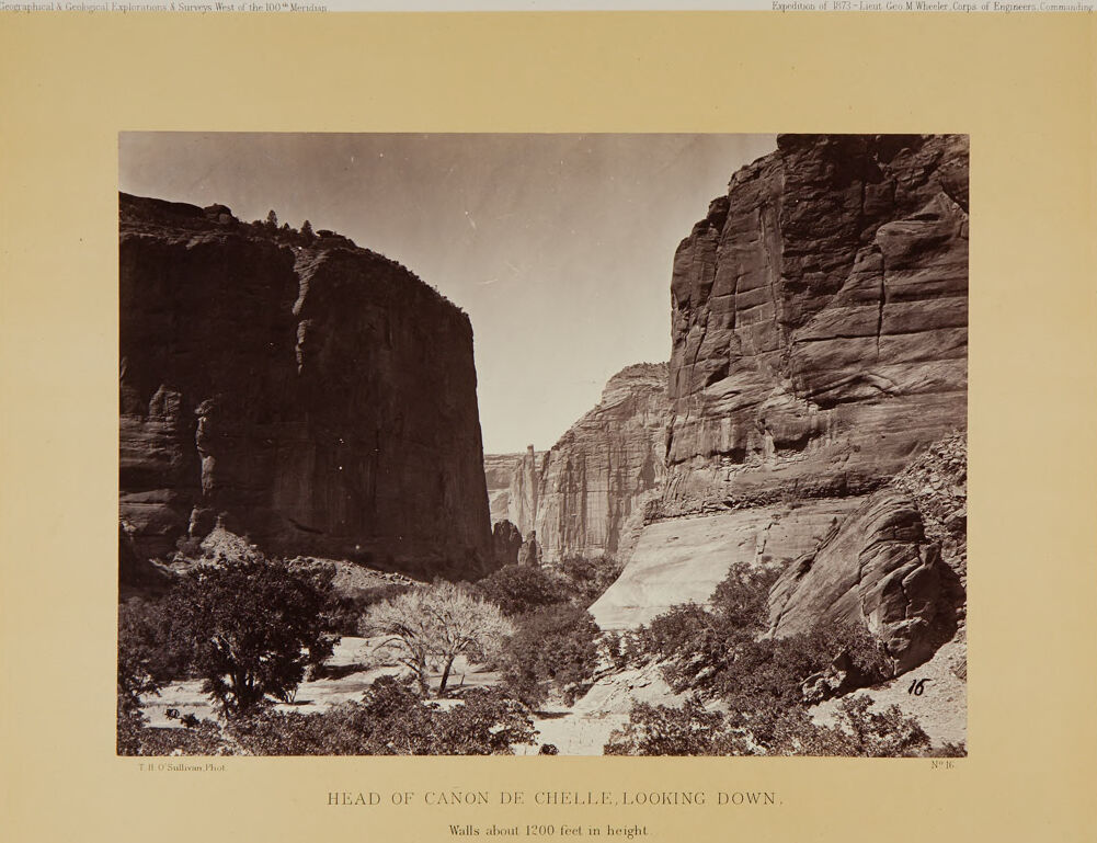
| Painting | 94.4% | |


Categories
Imagga
created on 2022-01-09
| paintings art | 90.2% | |
| nature landscape | 6.6% | |
| streetview architecture | 2.1% | |
Captions
Microsoft
created by unknown on 2022-01-09
| a screenshot of a computer | 33.2% | |
| a close up of a computer | 28.7% | |
| a screen shot of a computer | 28.6% | |
Clarifai
Created by general-english-image-caption-clip on 2025-07-14
a city in the past, history.
Salesforce
Created by general-english-image-caption-blip on 2025-05-22
a photograph of a black and white photo of a canyon
OpenAI GPT
Created by gpt-4 on 2024-01-26
This is a sepia-toned photograph showing a view of a deep canyon named "Canon de Chelle," with the vantage point looking downward into the canyon. Imposing cliffs rise dramatically on either side, with their walls approximately 1200 feet high, showcasing layered sedimentary rock formations with visible striations, indicative of significant geological history.
The canyon floor is dotted with trees, including some relatively lush vegetation given the arid environment suggested by the rocky terrain. This greenery adds a touch of life to the otherwise stark and towering landscape.
The photograph also features a label at the bottom left corner, attributing the work to T.H. O'Sullivan, who was the photographer, and it is indicated to be part of the "Geographical & Geological Explorations & Surveys West of the 100th Meridian" and the "Expedition of 1873, Lieut. Geo. M. Wheeler, Corps of Engineers Commanding." It is numbered "No. 46." This image was likely used for cartographic and scientific purposes, to document and understand the geography of the western United States during the time period.
Anthropic Claude
Created by us.anthropic.claude-3-5-sonnet-20241022-v2:0 on 2025-06-28
This is a historic black and white photograph titled "Head of Canon de Chelle, Looking Down" with walls noted to be about 1,200 feet in height. The image shows a dramatic view of Canyon de Chelly with its imposing sandstone walls rising on both sides of the frame. The canyon walls are steep and striated, showing clear layers of rock formation. In the canyon floor, there are scattered trees and vegetation, creating a contrast between the harsh vertical cliff faces and the more gentle organic forms below. The photograph appears to be from a geological survey, as indicated by the header text mentioning "Geographical & Geological Explorations & Surveys West of the 100th Meridian" and was taken during an 1873 expedition led by Lt. Geo. M. Wheeler of the Corps of Engineers. The photographer is credited as T.H.O'Sullivan. The image captures the impressive scale and geological features of this significant southwestern landscape.
Created by claude-3-haiku-48k-20240307 on 2024-03-29
The image depicts a dramatic natural landscape featuring towering cliffs and rock formations. In the foreground, there is a winding river or stream surrounded by lush vegetation. The cliffs and canyon walls reach up to an estimated 1,200 feet in height, creating an awe-inspiring and rugged scene. The overall impression is one of scale, power, and the majestic beauty of the natural world.
Meta Llama
Created by us.meta.llama3-2-90b-instruct-v1:0 on 2024-12-26
The image is a sepia-toned photograph of a canyon, with the title "HEAD OF CANON DE CHELLE, LOOKING DOWN" at the bottom. The photo shows a narrow canyon with steep cliffs on either side, and a small tree in the foreground. The sky above is clear and bright.
Key Features:
- Canyon: The canyon is narrow and deep, with steep cliffs on either side.
- Cliffs: The cliffs are made of rock and are covered in vegetation.
- Tree: A small tree is visible in the foreground, near the center of the photo.
- Sky: The sky above is clear and bright, with no clouds visible.
- Title: The title of the photo is "HEAD OF CANON DE CHELLE, LOOKING DOWN", which suggests that the photo was taken from a high vantage point looking down into the canyon.
- Caption: Below the title, there is a caption that reads "Walls about 1200 feet in height", which provides additional information about the size of the canyon.
Overall Impression:
The image gives the impression of a remote and rugged landscape, with steep cliffs and a narrow canyon. The presence of vegetation on the cliffs suggests that the area may be more hospitable than it initially appears. The clear sky and bright lighting add to the sense of drama and grandeur in the image.
Created by us.meta.llama3-2-11b-instruct-v1:0 on 2024-12-02
The image is a sepia-toned photograph of a canyon, with the title "HEAD OF CAÑON DE CHELLE, LOOKING DOWN" and the caption "Walls about 1200 feet in height."
- The photograph is taken from a distance, looking down into the canyon.
- The canyon walls are steep and rocky, with some trees and bushes growing on them.
- The sky above the canyon is clear and bright, with no clouds visible.
- The overall atmosphere of the image is one of grandeur and awe, with the vastness of the canyon and the height of the walls creating a sense of wonder and exploration.
The image appears to be a historical photograph, possibly from the late 19th or early 20th century, given the sepia tone and the style of the caption. It may have been taken by a photographer who was exploring the American Southwest during this time period.
Amazon Nova
Created by amazon.nova-lite-v1:0 on 2025-06-07
The image is a black-and-white photograph of a canyon. The photograph is titled "HEAD OF CANON DE CHELLE, LOOKING DOWN." The canyon walls are steep and high, and there are trees and plants growing on the sides. The photograph was taken by T.H. O'Sullivan, and it was part of the Geographical and Geological Explorations and Surveys West of the 100th Meridian Expedition of 1873, led by Lieutenant Geo M. Wheeler of the Corps of Engineers. The photograph is dated 1873.
Created by amazon.nova-pro-v1:0 on 2025-06-07
The image is a photograph of a canyon. The canyon is surrounded by large, steep rock walls on both sides, with a narrow, winding path between them. The canyon is surrounded by trees, and there is a small stream running through it. The canyon is a natural wonder, and the photograph captures its beauty and grandeur. The image is in black and white, which adds to its timeless quality.
Google Gemini
Created by gemini-2.0-flash-lite on 2025-05-17
This is a black and white photograph of a canyon. The view is looking down the canyon with its towering walls on either side. The walls are composed of layered rock formations. Vegetation is present on the canyon floor. The title reads: "HEAD OF CANON DE CHELLE, LOOKING DOWN, Walls about 1200 feet in height". The photographer's name is "T. H. O'Sullivan, Phot." with "N° 16" written in the lower right corner. The top of the frame has a title that reads: "Geographical & Geological Explorations & Surveys West of the 100 Meridian" and "Expedition of 1873-Laeut Geo M Wheeler, Corps of Engineers, Commanding".
Created by gemini-2.0-flash on 2025-05-17
Here is a description of the image:
The image is a sepia-toned photograph titled "HEAD OF CAÑON DE CHELLE, LOOKING DOWN," taken by T.H. O'Sullivan. It depicts a canyon with towering rock formations on either side. The canyon walls are steep and appear to be approximately 1200 feet in height, according to the inscription below the image.
The left canyon wall is dark, and the rock formations have distinct vertical lines and rugged textures. There are a few small trees visible at the top of the canyon. At the base of the canyon, a variety of trees and shrubs are visible, adding a touch of greenery to the scene.
The right canyon wall is lighter in color compared to the left. The rock formations show different layers and textures, with some visible erosion.
The image is framed in a light tan border, and there are inscriptions along the top of the border. The inscriptions are "Geographical & Geological Explorations & Surveys West of the 100th Meridian" on the left and "Expedition of 1873-Lieut Geo M Wheeler, Corps of Engineers, Commanding" on the right. At the bottom right corner of the photograph itself, there is the number "16" marked.
Mistral Pixtral
Created by us.mistral.pixtral-large-2502-v1:0 on 2025-06-02
The image depicts a stunning view of a canyon, specifically the "Head of Cañon de Chelle," which is part of Canyon de Chelly located in northeastern Arizona. The photograph is taken from a high vantage point, looking down into the canyon. The sheer cliff walls on either side of the canyon are approximately 1200 feet in height, showcasing the impressive depth and scale of the natural formation.
The canyon walls display distinct layers of sedimentary rock, indicating various geological periods. Vegetation is sparse but present, with some trees and shrubs visible along the canyon floor and on the rocky ledges. The lighting suggests it might be early morning or late afternoon, casting shadows that accentuate the texture and contours of the rock formations.
The photograph is part of a geographical and geological exploration survey conducted west of the 100th Meridian, specifically during the expedition of 1873 led by Lieutenant George M. Wheeler of the Corps of Engineers. The image is labeled with the title "Head of Cañon de Chelle. Looking Down. Walls about 1200 feet in height" and is marked as plate number 46. The photograph is credited to T. H. O'Sullivan, Phot.
Overall, the image captures the rugged beauty and geological significance of Canyon de Chelly, highlighting its vast scale and natural splendor.
Qwen
Created by Qwen/Qwen2.5-VL-7B-Instruct on 2025-07-10
The image is a historical black-and-white photograph titled "HEAD OF CANON DE CHELLE, LOOKING DOWN." The text at the bottom indicates the height of the walls as about 1200 feet. The photograph captures a deep canyon with steep, rugged rock walls. The walls of the canyon are a mix of dark and light tones, indicative of sedimentary rock strata. The bottom of the canyon is filled with vegetation, including trees and shrubs, suggesting a contrast between the harshness of the rock formations and the life that persists in the area. The sky is clear, and the overall tone of the image suggests it was taken during the 1873 expedition by Lieutenant George M. Wheeler and the Corps of Engineers. The image is part of a series of Geographical and Geological Explorations & Surveys West of the 100th Meridian.
Created by Qwen/Qwen2.5-VL-72B-Instruct on 2025-07-10
This image is a sepia-toned historical photograph depicting the "Head of Canon de Chelle" as described in the caption below the main image. The scene shows a dramatic canyon landscape with towering rock formations on either side. The walls of the canyon appear to be layered with sedimentary rock and stand approximately 1,200 feet in height. The foreground contains sparse vegetation, including small trees and shrubs, suggesting a semi-arid environment. The photograph is framed by a beige border with text at the top and bottom. The top text mentions "Geographical & Geological Explorations & Surveys West of the 100th Meridian" and "Expedition of 1873 - Lieut. Geo. M. Wheeler, Corps of Engineers, Commanding." The bottom text reads "HEAD OF CANON DE CHELLE, LOOKING DOWN. Walls about 1200 feet in height." The photograph is credited to "T. H. O'Sullivan, Phot." and is numbered "No. 16." The overall tone of the image and the style of the text suggest that it is from a historical exploration and survey expedition.
Text analysis
Amazon