Machine Generated Data
Tags
Color Analysis
Feature analysis
Amazon
Clarifai

Clarifai
| Poster | 85.1% | |
Categories
Imagga
created on 2022-05-28
| paintings art | 99.7% | |
Captions
Microsoft
created by unknown on 2022-05-28
| map | 85.4% | |
Clarifai
No captions written
Salesforce
Created by general-english-image-caption-blip on 2025-05-12
a photograph of a map of a city with a map of the city
Created by general-english-image-caption-blip-2 on 2025-07-01
a map of the city of new york, with the names of the streets
OpenAI GPT
Created by gpt-4o-2024-11-20 on 2025-06-17
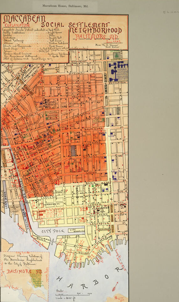
This image is a historical map depicting the "Maccabean Social Settlement Neighborhood" in Baltimore, Maryland, produced in 1904. The map highlights an urban area near Baltimore's harbor, divided into sections shaded in different colors.
Key Features:
Title Area: At the top, a handwritten title reads "Maccabean Social Settlement Neighborhood Baltimore, MD," providing the context of the map. An explanation box underneath lists demographic and cultural details about the area, such as populations from Russian, Polish, Lithuanian, German, and Irish Jewish communities.
Color Coding:
- Orange/Shaded Area: Indicates the main concentration of the settlement area.
- Yellow Area: Denotes adjacent or surrounding neighborhoods with distinct demographic groups.
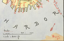
Urban Layout: The map shows a detailed street grid with labeled streets, buildings, docks, and other urban elements. Residences, businesses, and community spaces are marked, likely representing where specific populations settled or worked.
Harbor Area: A portion of the Baltimore Harbor and City Dock is prominently outlined at the bottom, emphasizing the settlement's proximity to maritime activity.
Inset Map: A smaller inset map at the lower-left corner provides a broader view of Baltimore and situates the neighborhood within the city at large.
This map appears to be both an urban demographic study and a visual representation of cultural and immigrant settlement patterns at the time. It provides insight into the social geography of Baltimore in the early 20th century.
Created by gpt-4o-2024-08-06 on 2025-06-17
The image is a historical map titled "Maccabean Social Settlement Neighborhood, Baltimore, MD," created in March 1907. It appears to be a detailed drawing of a specific area of Baltimore, Maryland, highlighting a community known as the Maccabean Settlement.
The map is divided into blocks and streets, with a significant portion of it shaded in red, indicating the extent of the settlement. The layout includes numerous city blocks, street names, and markings showing the composition of the neighborhood. There are notes and a legend explaining symbols used on the map, which might represent different types of facilities, social institutions, or population demographics.
In the top left corner, there is a box titled "Explanation," likely detailing what each symbol or color on the map represents. At the bottom of the map, there is a smaller inset showing the broader location of Baltimore within the state of Maryland, emphasizing the city and the region being mapped.
The map also shows the city's waterfront and harbor, indicating the general area within Baltimore being referenced. In the lower section of the map, there are mentions of docks and the harbor, suggesting the neighborhood's proximity to these areas.
Overall, the image is a historic and detailed representation of the Maccabean community within early 20th-century Baltimore.
Anthropic Claude
Created by anthropic.claude-3-haiku-20240307-v1:0 on 2025-06-11
This image appears to be a historical map of the Maccabean Social Settlement neighborhood in Baltimore, Maryland. The map shows a detailed layout of the city streets and blocks, with various annotations and labels indicating different areas and features of the neighborhood. The map includes a legend or explanation of the "Maccabean Social Settlement Neighborhood" at the top. Overall, this seems to be a detailed urban planning or community development map from a historical period.
Created by us.anthropic.claude-3-opus-20240229-v1:0 on 2025-06-11
The image shows a detailed map titled "Maccabean Social Settlement Neighborhood Baltimore, MD." It depicts the layout and street plan of a neighborhood in Baltimore, with different colored sections indicating various zones or districts. The map includes street names, block numbers, and a legend explaining the color coding. The level of detail suggests this was likely an official city planning or zoning map used to guide the development and organization of this particular neighborhood in Baltimore at the time the map was created.
Created by us.anthropic.claude-3-5-sonnet-20241022-v2:0 on 2025-06-11
This is a historical map showing the Maccabean Social Settlement neighborhood in Baltimore, Maryland. The map appears to be from around 1901 and shows a detailed street layout of the area near Baltimore's harbor. The map is color-coded, with a large section in salmon/coral pink in the upper portion, and lighter colored areas toward the harbor at the bottom. There's a small inset map in the lower left corner showing the location within Baltimore, and a legend or explanation box at the top. The map includes detailed block divisions, street names, and shows the harbor's edge with its various docks and piers. The level of detail suggests this was likely used for urban planning or social documentation purposes. The map's orientation shows the harbor at the bottom, and the neighborhood extends northward with a grid-like street pattern that becomes slightly irregular toward the northwest portion of the mapped area.
Meta Llama
Created by us.meta.llama3-2-11b-instruct-v1:0 on 2025-06-04
The image presents a map of the Maccabean Social Settlement Neighborhood in Baltimore, Maryland, dated June 1907. The map is divided into two sections: the top section features a key and an explanation of the map's symbols, while the bottom section displays the map itself.
Key and Explanation:
- The key explains the symbols used on the map, including:
- Buildings
- Streets
- Parks
- Schools
- Churches
- Hospitals
- Other notable features
Map:
- The map is hand-drawn and colored, with a light brown background and darker brown lines indicating streets.
- The map shows the location of various buildings, including:
- Residences
- Commercial buildings
- Institutions
- The map also highlights notable features, such as:
- Parks
- Schools
- Churches
- Hospitals
- The map includes a legend that explains the symbols used to represent different types of buildings and features.
Additional Information:
- The map is labeled "Maccabean House, Baltimore, Md." at the top.
- The date "June 1907" is written in the top-right corner.
- The map appears to be a hand-drawn copy of an original map, as evidenced by the uneven edges and slight discoloration.
Overall, the map provides a detailed view of the Maccabean Social Settlement Neighborhood in Baltimore, Maryland, in 1907. It highlights the location of various buildings and features, as well as notable institutions and landmarks.
Created by us.meta.llama3-2-90b-instruct-v1:0 on 2025-06-04
The image is a map of Baltimore, Maryland, specifically the Maccabean House neighborhood. The map appears to be hand-drawn and features a mix of orange, yellow, and white colors. It includes various symbols and markings, such as red lines, blue squares, and handwritten notes.
Key Features:
- Title: "Maccabean Social Settlement Neighborhood Baltimore MD" is written in red at the top of the map.
- Date: The map is dated 1907.
- Scale: The scale of the map is not explicitly stated, but it appears to be a relatively small-scale map, showing several city blocks.
- Symbols and Markings: The map features various symbols and markings, including:
- Red lines: These may represent streets, boundaries, or other features.
- Blue squares: These could indicate buildings, parks, or other landmarks.
- Handwritten notes: These provide additional information about the neighborhood, such as the location of schools, churches, and other community facilities.
- Neighborhood Boundaries: The map shows the boundaries of the Maccabean House neighborhood, which is located in the heart of Baltimore.
- Surrounding Areas: The map also depicts surrounding neighborhoods and landmarks, including the Inner Harbor and the Baltimore City Dock.
Overall:
The map provides a detailed view of the Maccabean House neighborhood in Baltimore, Maryland, as it existed in 1907. It highlights the neighborhood's layout, including its streets, buildings, and community facilities. The map is likely to be of interest to historians, urban planners, and anyone studying the development of Baltimore's neighborhoods during the early 20th century.
Amazon Nova
Created by amazon.nova-lite-v1:0 on 2025-06-04
The image shows a map of the Maccabees Social Settlement neighborhood in Baltimore, Maryland. The map is drawn in red ink on a white background and includes a legend in the upper left corner. The map shows the location of the Maccabees Social Settlement, as well as the surrounding streets and buildings. The map also includes a note in the upper right corner that reads "Maccabees House, Baltimore, Md." The map appears to be an old document, possibly from the early 20th century.
Created by amazon.nova-pro-v1:0 on 2025-06-04
The image shows a map of the Maccabean Social Settlement neighborhood in Baltimore, Maryland. The map is titled "Maccabean Social Settlement Neighborhood Baltimore, Md." The map is in a rectangular shape and is colored in orange, green, and blue. The map shows the streets, buildings, and other landmarks in the neighborhood. The map also includes a legend that explains the different colors and symbols used on the map. The map is dated 1910 and was created by the Maccabean House.
Google Gemini
Created by gemini-2.0-flash-lite on 2025-05-13
Here's a description of the image:
Overall Impression:
The image is a historical map of the "Maccabean Social Settlement Neighborhood" in Baltimore, Maryland, dated June 1907. It appears to be a hand-drawn and colored map, likely created as part of a social survey or community study.
Map Features and Color Coding:
- Neighborhood Depiction: The map focuses on a specific area of Baltimore, with a grid-like pattern representing city streets. The area is marked with a prominent, brightly colored district that is red or orange.
- Color Coding Key: There's a key labeled "Explanation" that uses different colors to represent various features:
- Red/Orange: Indicates a densely populated or congested Jewish district.
- Bright Green: Indicates Gentile areas.
- Blue Industrial areas, etc.
- Others: Indicates the location of other types of establishments, streets, railways and waterways.
- Points of Interest: Small red dots or symbols are used to mark specific locations, such as shops or public buildings.
- Waterways and Harbor: The southern portion of the map features the Baltimore Harbor, depicted in blue. The water is the harbor.
- Inset Map: In the bottom left corner, there's a smaller inset map that shows the relationship of the Maccabean neighborhood to the overall city of Baltimore.
Additional Elements:
- Title: "Maccabean Social Settlement Neighborhood - Baltimore, MD"
- Date: The map is dated "June 1907".
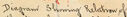
- Annotations: The map includes several handwritten annotations, such as the name of the individual who created it: "Miss M. S. Hanaw"
- Scale: The map includes a scale to indicate distance.
Overall Purpose:
This map was likely created to:
- Illustrate the demographic and geographic characteristics of a specific neighborhood in Baltimore.
- Visually represent the location of the Maccabean settlement in relation to other community elements.
- To support the study of the social and economic conditions of the time.
- To show where Gentile areas were located in addition to industrial and street railway locations
The map serves as a valuable historical document, providing insights into urban development, social dynamics, and the lived experiences of residents in early 20th-century Baltimore.
Created by gemini-2.0-flash on 2025-05-13
Here's a description of the image:
The image shows a historic map titled "Maccabean Social Settlement Neighborhood - Baltimore, MD." It was created in June 1907 by Miss M. S. Hanaw and Ruth Warner. The map appears to be mounted on a gray backing sheet.
The map depicts a portion of Baltimore, with streets, blocks, and waterways. The "congested Jewish District" is prominently marked in red on the map. Other features and areas of the city are labeled, including the "City Dock" and "Harbor." The map also includes a key explaining the color-coding used to represent different features.
At the bottom left is a smaller diagram showing the relationship of the Maccabean Neighborhood to the City of Baltimore. There is also a scale provided for reference.
The map is annotated with an "Explanation" key that uses color to indicate different social settlement neighborhoods.
Mistral Pixtral
Created by us.mistral.pixtral-large-2502-v1:0 on 2025-06-02
The image is a detailed map of the Maccabean Social Settlement Neighborhood in Baltimore, Maryland. The map appears to be from the early 20th century, as indicated by the style and content. Here are some key features of the map:
Title and Explanation:
- The title at the top reads "Maccabean Social Settlement Neighborhood - Baltimore, Md."
- An explanation box in the upper left corner provides a key for various symbols used on the map. The symbols represent different types of buildings and facilities such as:
- Synagogues (indicated by a star of David)
- Public schools (indicated by a schoolhouse symbol)
- Public baths (indicated by a bath symbol)
- Playgrounds (indicated by a playground symbol)
- Libraries (indicated by a book symbol)
- Parks (indicated by a tree symbol)
- Hospitals (indicated by a cross symbol)
- Fire stations (indicated by a fire hydrant symbol)
- Police stations (indicated by a police badge symbol)
Color Coding:
- The map uses different colors to represent various areas. The predominant color is orange, which likely signifies the Maccabean Social Settlement Neighborhood.
- Other colors and shading might indicate different types of land use or different neighborhoods.
Geographical Features:
- The map includes the city dock and the harbor, which are significant geographical features of Baltimore.
- The layout of streets and blocks is clearly depicted, showing the urban grid of the neighborhood.
Inset Map:
- There is an inset map in the lower left corner showing the location of the Maccabean Social Settlement Neighborhood within the larger context of the city of Baltimore and the state of Maryland.
Scale and Orientation:
- The map includes a scale bar and a north arrow for orientation.
Date:
- The map is dated 1924, as indicated in the lower right corner.
This map provides a historical snapshot of the Maccabean Social Settlement Neighborhood in Baltimore, highlighting important community facilities and the urban layout of the area during that time.
Qwen
Created by Qwen/Qwen2.5-VL-7B-Instruct on 2025-07-10
This image is a historical map of Baltimore, Maryland, titled "Maccabean Social Settlement Neighborhood." The map appears to be from June 1901, as indicated at the top right corner. The map is colored with various shades of orange and blue, representing different areas within the neighborhood.
Key features of the map:
Title and Description: The top section of the map is labeled "Maccabean Explanation," followed by "Social Settlement Neighborhood," and "Baltimore MD June 1901." This suggests that the map is related to a specific social settlement initiative based in the Maccabean House.
Neighborhood Layout: The map displays the layout of the neighborhood with streets and blocks clearly marked. Different shades are used to distinguish various sections within the neighborhood, possibly indicating different social or economic characteristics.
Key Places: The map includes labels for significant areas such as "City Dock," "Harbor," and various street names, indicating its proximity to the harbor.
Legend: The bottom left section of the map includes a legend, which is not fully legible in the image provided. It likely provides information on what the different colors and symbols represent on the map.
Scale: The map includes a scale at the bottom, which helps in understanding the size and distance of the neighborhood relative to the city of Baltimore.
Overall, this map seems to be a detailed representation of a specific social settlement area within Baltimore, providing a snapshot of its layout and key landmarks at the turn of the 20th century.
Created by Qwen/Qwen2.5-VL-72B-Instruct on 2025-07-10
This image is a historical map titled "Maccabaean Social Settlement Neighborhood Baltimore MD," dated June 1901. The map provides a detailed view of a specific area in Baltimore, Maryland, focusing on the Maccabaean Social Settlement neighborhood.
The map is color-coded and includes various annotations and symbols to indicate different types of buildings, institutions, and other features within the neighborhood. The colors used include shades of orange, red, yellow, and blue, with each color representing a different type of building or area.
There is an explanation section at the top left corner of the map that lists the types of buildings and features represented by the different colors and symbols. The map also includes a small inset diagram at the bottom left corner that shows the location of the Maccabaean Neighborhood in relation to the city of Baltimore.
The map is bordered by a light gray frame, and the text and annotations are written in a mix of red and black ink. The map provides a comprehensive overview of the neighborhood's layout, including streets, buildings, and other significant features.
Text analysis
Amazon