Machine Generated Data
Tags
Color Analysis
Feature analysis
Amazon
Clarifai
AWS Rekognition
| Rug | 81.9% | |


Categories
Imagga
created on 2022-01-22
| nature landscape | 47.9% | |
| streetview architecture | 24.2% | |
| interior objects | 16% | |
| paintings art | 5.6% | |
| food drinks | 2.6% | |
| beaches seaside | 2.2% | |
Captions
Microsoft
created by unknown on 2022-01-22
| a close up of a box | 75.6% | |
| close up of a box | 70.7% | |
| a close up of a pizza box | 28.5% | |
Clarifai
Created by general-english-image-caption-clip on 2025-07-15
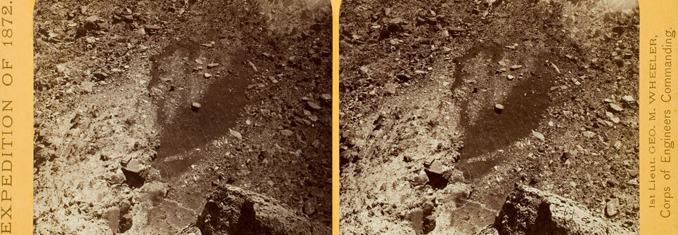
photograph of a rock formation.
Salesforce
Created by general-english-image-caption-blip on 2025-05-18
a photograph of two old time photos of a man in a trench
OpenAI GPT
Created by gpt-4o-2024-11-20 on 2025-06-18
The image is a stereoscopic photograph from 1872, showing a rugged, rocky landscape. It looks like a barren and uneven terrain, possibly a dried-out riverbed or a volcanic crater. The foreground features large, jagged rocks, while the background reveals uneven slopes or ridges, possibly with snow or lighter-colored sediment at the top. The image is presented as a stereograph—a pair of nearly identical photographs intended for viewing through a stereoscope to create a three-dimensional effect. The yellow border includes text that identifies it as part of the "Expedition of 1872" and credits "1st Lieut. Geo. M. Wheeler, Corps of Engineers Commanding."
Created by gpt-4o-2024-08-06 on 2025-06-18
The image is a stereoscopic photograph, which is designed to be viewed with a stereoscope to give a three-dimensional effect. It depicts a rough, rocky terrain that appears to be part of a barren landscape, possibly a canyon or volcanic crater. The foreground shows jagged rocks and a steep slope leading downward. The background appears to have a ridge or horizon line with a slightly lighter area, possibly owing to sunlit snow or rock formations. The photograph is bordered by a yellow frame with text.
The left side of the frame reads "EXPEDITION OF 1872," indicating that this image is from a historical expedition. The right side has the text "1st Lieut. GEO. M. WHEELER, Corps of Engineers Commanding," signifying that the photograph was taken under the command of Lieutenant George M. Wheeler, who was known for his exploration and mapping of the American West during the 19th century.
Anthropic Claude
Created by anthropic.claude-3-haiku-20240307-v1:0 on 2025-06-22
The image appears to be a stereo photograph, or a pair of images side-by-side, depicting a snowy, mountainous landscape. The scene shows a rugged, rocky terrain covered in snow, with mountains visible in the background. The image has a sepia tone, characteristic of early photographic processes, indicating this is an older photograph. The format of the image, with two identical views side-by-side, suggests this was intended to be viewed through a stereoscopic viewer to create a three-dimensional effect.
Created by us.anthropic.claude-3-5-sonnet-20241022-v2:0 on 2025-06-22
This is a historical stereoscopic photograph from 1872, showing what appears to be a mining or excavation site. The image shows a rocky, crater-like formation or pit with rough, uneven walls and loose debris. The photograph has a sepia tone typical of images from that era and is mounted on a yellow/orange card mount. The text on the mount indicates this was part of an "EXPEDITION OF 1872" and appears to be associated with the Corps of Engineers. The stereoscopic format consists of two nearly identical images placed side by side, which when viewed through a special viewer would have created a 3D effect for the viewer.
Created by us.anthropic.claude-3-opus-20240229-v1:0 on 2025-06-22
The image shows two nearly identical sepia-toned photographs side by side. Each photograph depicts a rocky, mountainous landscape with steep cliffs and boulders. In the center of each photograph, there appears to be a human figure sitting or crouching among the rocks, though the details are hard to make out due to the age and quality of the photographs. The overall scene has a rugged, wilderness feel to it, likely captured somewhere in a remote mountainous region during the early days of photography based on the antique appearance of the stereoscopic card mount.
Meta Llama
Created by us.meta.llama3-2-11b-instruct-v1:0 on 2025-06-10
The image is a sepia-toned stereograph photograph of a rocky cliffside, with a large boulder in the foreground and a steep slope behind it. The cliffside appears to be composed of rough, jagged rocks and dirt.
The photograph is divided into two halves, with the left half showing the cliffside from a slightly different angle than the right half. The edges of the photograph are yellowed and worn, with some creases and tears visible.
The photograph is mounted on a yellowed cardstock, with the words "EXPEDITION OF 1872" printed vertically along the left edge and "1st Lieut. GEO. M. WHEELER, Corps of Engineers Commanding" printed vertically along the right edge. The cardstock has a rounded top edge and a straight bottom edge.
Overall, the image appears to be a historical photograph taken during an expedition in 1872, possibly documenting a geological or geographical feature of interest.
Created by us.meta.llama3-2-90b-instruct-v1:0 on 2025-06-10
The image is a sepia-toned stereoscopic photograph of a rocky landscape, with the title "EXPEDITION OF 1872" printed vertically along the left edge. The photograph is divided into two identical images, one on each side of the card, which are meant to be viewed through a stereoscope to create a three-dimensional effect.
In the foreground, there is a large rock formation that appears to be a cliff or a mountainous terrain. The rock is covered in dirt and debris, and there are several smaller rocks scattered around the base of the cliff. In the background, there is a vast expanse of open land that stretches out to the horizon. The sky above is clear and cloudless, with a subtle gradient of light and dark tones that gives the image a sense of depth and dimensionality.
Along the right edge of the card, there is some text that reads: "1st Lieut. GEO. M. WHEELER, Corps of Engineers Commanding." This suggests that the photograph was taken by or under the command of Lieutenant George M. Wheeler, who was a member of the Corps of Engineers during the expedition of 1872.
Overall, the image provides a glimpse into the rugged and unforgiving landscape of the American West during the late 19th century, and serves as a testament to the bravery and determination of the explorers who ventured into this uncharted territory.
Amazon Nova
Created by amazon.nova-lite-v1:0 on 2025-06-05
The image is a black-and-white photograph with a yellow border at the top and bottom. It appears to be a stereoscopic image, with two slightly different views of the same scene. The photograph depicts a rocky landscape with a prominent mountain range in the background. The foreground is filled with rocks and dirt, and there is a narrow path or trail that appears to lead up the mountain. The image is labeled "Expedition of 1872" and "1st Lieut. Geo. M. Wheeler, Corps of Engineers, Commanding."
Created by amazon.nova-pro-v1:0 on 2025-06-05
The image is a stereoscopic photograph, which means it consists of two slightly different images placed side by side to create a 3D effect when viewed through a stereoscope. The photograph depicts a rugged, rocky landscape with a dark, muddy river running through it. The river appears to be flowing from the top of the image downward, carving a path through the rocky terrain. The rocks and stones surrounding the river are of various sizes and shapes, suggesting a natural, untamed environment. The overall atmosphere of the image is one of desolation and harshness, with no signs of human activity or vegetation visible.
Google Gemini
Created by gemini-2.0-flash on 2025-05-16
Here is a description of the image:
This is a stereoscopic image from the "Expedition of 1872," commanded by 1st Lieutenant Geo. M. Wheeler of the Corps of Engineers. The image presents two nearly identical views of what appears to be a rugged landscape, possibly a section of mountainous terrain or a quarry, with an abundance of rocks and earthy material.
In the foreground, there are large rocks, one of which dominates the lower center of the frame. It has a rough texture with some exposed strata. Behind this large rock, the ground rises steeply, covered with smaller rocks and sediment. There seems to be a small hollow or depression further up, with what might be water collected within.
In the background, a level horizon can be seen, indicating a higher ground or ridge that seems to run horizontally across both images. The sepia tones give the scene an aged and somewhat monochromatic appearance, consistent with photography from the late 19th century.
The image is presented on a yellowed card stock, with text printed on either side of the two circular images, indicating the expedition and the commanding officer. This type of stereoscopic card was designed to be viewed through a stereoscope, creating a three-dimensional effect of the scene.
Created by gemini-2.0-flash-lite on 2025-05-16
Here is a description of the image:
The image is a stereoscopic photograph dating from the Expedition of 1872, and the title says it's of "1st Lieut. Geo. M. Wheeler, Corps of Engineers Commanding." The photograph is sepia-toned, and the image is presented in the typical style of stereo photographs, with two near-identical images side by side. The scene appears to be a high-angle shot of a rocky terrain, likely a geological formation or a canyon. The foreground is dominated by large rocks and smaller stones, with areas of bare earth visible. In the center, there's a dark, shadowy area that could be a depression or a water-filled crevice. The background shows a distant view of a higher elevation, possibly a cliff or a ridge, with a lighter area that might indicate the sky or a plateau. The overall impression is a stark, rugged landscape, captured in a somewhat faded and aged condition, typical of photographs from that era. The photo's purpose was likely to document the exploration and survey work of the Corps of Engineers.
Mistral Pixtral
Created by us.mistral.pixtral-large-2502-v1:0 on 2025-06-03
The image is a stereoscopic photograph from the year 1872, taken by 1st Lieutenant George M. Wheeler of the Corps of Engineers. Stereoscopic photographs are designed to be viewed through a stereoscope to create a three-dimensional effect.
The photograph shows a rugged, rocky landscape with a prominent rock formation in the center. The terrain appears to be arid and barren, with various rock fragments and debris scattered across the ground. The rock formation in the center is darker in color and seems to be eroded or weathered, possibly due to natural processes over time. The sky is visible at the top of the image, suggesting that the photograph was taken outdoors in a natural setting.
The photograph is mounted on a yellowish card with text on the left and right sides. The text on the left reads "EXPEDITION OF 1872," indicating that this image was taken during an expedition conducted in that year. The text on the right identifies the photographer and his rank, "1st Lieut. GEO. M. WHEELER, Corps of Engineers Commanding."
Overall, the image captures a geological feature in a desert-like environment, providing a glimpse into the natural landscapes explored during the 1872 expedition.
Qwen
Created by Qwen/Qwen2.5-VL-7B-Instruct on 2025-07-14
The image shows a stereoscopic photograph from the expedition of 1872, as indicated by the text on the left side of the image. It appears to depict a rocky terrain with a deep, narrow trench or crevice cutting through it. The photograph is sepia-toned, giving it an antique appearance, and the edges of the image are framed in a light yellow border. The text on the right side of the image identifies the expedition as part of the Corps of Engineers, with "1st Lieut. Geo. M. Wheeler" mentioned, suggesting that this photograph was taken during one of George M. Wheeler's expeditions. The image likely captures a natural or man-made feature of interest, possibly related to geological or survey work.
Created by Qwen/Qwen2.5-VL-72B-Instruct on 2025-07-14
This image is a stereoscopic photograph, designed to create a three-dimensional effect when viewed through a stereoscope. It is part of the "Expedition of 1872," as indicated by the text on the left side of the image. The photograph was taken under the command of 1st Lieutenant Geo. M. Wheeler, Corps of Engineers.
The scene depicted shows a rugged, rocky landscape. There are large boulders and rocky terrain, suggesting a mountainous or hilly region. The terrain appears to be barren, with no visible vegetation. The photograph captures the texture and details of the rocks and the uneven ground, providing a sense of the challenging environment explored during the expedition. The overall tone of the image is sepia, typical of photographs from the late 19th century.
Text analysis
Amazon